- Cañitas de Felipe Pescador Municipality
-
Municipality of Cañitas de Felipe Pescador — Municipality — Location of Cañitas de Felipe Pescador with in Zacatecas and Mexico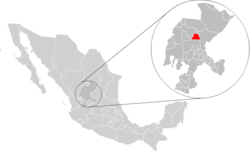
Coordinates: 24°15′N 102°30′W / 24.25°N 102.5°WCoordinates: 24°15′N 102°30′W / 24.25°N 102.5°W Country  Mexico
State Zacatecas Municipal seat Cañitas de Felipe Pescador Largest city Cañitas de Felipe Pescador Founded 1921 (Donato Moreno) Municipality November 19, 1958 Government – Municipal President Rogelio Monreal Durón, PRD Area – Total 482 km2 (186.1 sq mi) Elevation 2,020 m (6,627 ft) Population (2005)[1] – Total 7,893 – Largest city 5,950 Cañitas de Felipe Pescador Time zone CST (UTC-6) Postal Code 98480, 98490 Area code(s) 458 Cañitas de Felipe Pescador is one of the 58 municipalities(similar to a county) in the state of Zacatecas, Mexico. It is located on the northern part of the state of Zacatecas and it is bounded by the municipalities of Río Grande, Villa de Cos, Fresnillo. The municipality covers a total surface area of 482 square kilometres (186 sq mi)[2].
Contents
History
The first inhabitants of Cañitas de Felipe Pescador where the Huichol Indians. In 1918 the region became populated with farmers. In 1921, governor Donato Moreno granted a motion to legally fund Cañitas with the expropriation of haciendas, where the city lies presently.[clarification needed] By doing so it was requested for the formation of an Ejido which led to Cañitas rising to the level of Independent Congregation of the Municipality of Fresnillo.
In 1921 the first school was founded with the name of Carlos A. Carrillo, which placed special attention to environmental education. That same year the train station was installed in Cañitas and the community of La Colorada was moved to Cañitas.
It wasn't until November 19, 1958 that Cañitas went from being a Congregation to become a Municipality. Gilberto Montes Monsiváis was named Municipal president and that same year elections are held in which Herón Domínguez was declared the winner and became the first elected municipal president of Cañitas de Felipe Pescador (1959–1961).[3]
Population
In the 2005 census Cañitas de Felipe Pescador, reported a population of 7,893.[1] Of these, 5,950 lived in the municipal seat and the remainder lived in surrounding rural communities.
Religion
Most of the population is Catholic with 93.83 percent, Protestants and Evangelics follow with 2.87% and the remainder are Seventh Day Adventists and Neo-Pentecostalists with 6.17 %.
Towns and Villages
- Cañitas de Felipe Pescador
- Boquilla de Abajo
- Los Caballos
- Cañitas Viejo (Cañitas Viejas)
- La Quemada
- San Francisco
- El Saucillo
- El Porvenir
- Potrero de Badillo (Badillo)
- Enrique Estrada
References
- ^ a b Link to tables of population data from Census of 2005 INEGI: Instituto Nacional de Estadística, Geografía e Informática
- ^ http://www.e-local.gob.mx/work/templates/enciclo/zacatecas/municipios/32006a.htm "Cañitas de Felipe Pescador", Encyclopedia de Municipios
- ^ http://www.zacatecas.gob.mx/Municipios/CañitasHist.htm
 State of Zacatecas
Municipalities
and
(municipal seats)Apozol (Apozol) · Apulco (Apulco) · Atolinga (Atolinga) · Florencia de Benito Juárez Municipality (Florencia de Benito Juárez) · Calera de Víctor Rosales Municipality (Víctor Rosales) · Cañitas de Felipe Pescador (Cañitas de Felipe Pescador) · Concepción del Oro (Concepción del Oro) · Cuauhtémoc (San Pedro Piedra Gorda) · Chalchihuites (Chalchihuites) · El Plateado de Joaquín Amaro (El Plateado de Joaquín Amaro) · El Salvador (El Salvador) · Fresnillo (Fresnillo) · Genaro Codina (Genaro Codina) · General Enrique Estrada (General Enrique Estrada) · General Francisco R Murguía (Nieves) · General Pánfilo Natera (General Pánfilo Natera) · Guadalupe (Guadalupe) · Huanusco (Huanusco) · Jalpa (Jalpa) · Jerez de García Salinas (Jerez) · Jiménez del Teul (Jiménez del Teul) · Juan Aldama (Juan Aldama, Zacatecas) · Juchipila (Juchipila) · Loreto (Loreto) · Luis Moya (Luis Moya, Zacatecas) · Mazapil (Mazapil) · Melchor Ocampo (Melchor Ocampo) · Mezquital del Oro (Mezquital del Oro) · Miguel Auza (Miguel Auza, Zacatecas) · Momax (Momax) · Monte Escobedo (Monte Escobedo) · Morelos (Morelos) · Moyahua de Estrada (Moyahua de Estrada) · Nochistlán de Mejía (Nochistlán de Mejía) · Noria de Ángeles (Noria de Ángeles) · Ojocaliente (Ojocaliente) · Pánuco (Pánuco) · Pinos (Pinos) · Río Grande (Río Grande) · Santa María de la Paz (Santa María de la Paz) · Saín Alto (Saín Alto) · Sombrerete (Sombrerete) · Susticacán (Susticacán) · Tabasco (Tabasco) · Tepechitlán (Tepechitlán) · Tepetongo (Tepetongo) · Teúl de González Ortega (Teúl de González Ortega) · Tlaltenango de Sánchez Román · Trancoso (Trancoso) · Trinidad García de la Cadena (Trinidad García de la Cadena) · (Valparaíso) · (Vetagrande) · (Villa de Cos) · (Villa García) · Villa González Ortega Municipality (Villa González Ortega) · (Villa Hidalgo) · (Villanueva) · (Zacatecas)
 Categories:


Wikimedia Foundation. 2010.