- Fresnillo
Infobox Settlement
official_name = Fresnillo
other_name =
native_name =
nickname =
settlement_type =
motto =
imagesize =
image_caption =
flag_size =
image_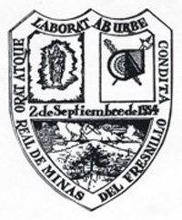
seal_size =
image_shield =
shield_size =
city_logo =
citylogo_size =
mapsize =200px
map_caption =
mapsize1 =
map_caption1 =
image_dot_
dot_mapsize =
dot_map_caption =
dot_x = |dot_y =
pushpin_
pushpin_label_position =
pushpin_map_caption =
pushpin_mapsize =
subdivision_type = Country
subdivision_name = MEX
subdivision_type1 = State
subdivision_name1 =Zacatecas
subdivision_type2 =Municipality
subdivision_name2 = Fresnillo
subdivision_type3 =
subdivision_name3 =
subdivision_type4 =
subdivision_name4 =
government_footnotes =
government_type =
leader_title =Mayor
leader_name =David Monreal Ávila
leader_title1 =
leader_name1 =
leader_title2 =
leader_name2 =
leader_title3 =
leader_name3 =
leader_title4 =
leader_name4 =
established_title = Founded
established_date =September 2 ,1554
established_title2 =
established_date2 =
established_title3 =
established_date3 =
area_magnitude =
unit_pref =
area_footnotes =
area_total_km2 =
area_land_km2 =
area_water_km2 =
area_total_sq_mi =
area_land_sq_mi =
area_water_sq_mi =
area_water_percent =
area_urban_km2 =
area_urban_sq_mi =
area_metro_km2 =
area_metro_sq_mi =
area_blank1_title =Municipality
area_blank1_km2 =
area_blank1_sq_mi =1910
population_as_of =2005
population_footnotes =
population_note =
population_total =110892
population_density_km2 =
population_density_sq_mi =
population_metro =
population_density_metro_km2 =
population_density_metro_sq_mi =
population_urban =
population_density_urban_km2 =
population_density_urban_sq_mi =
population_blank1_title =Municipality
population_blank1 =196538
population_blank2_title =Demonym
population_blank2 =Fresnillense
population_density_blank1_km2 =
population_density_blank1_sq_mi =
timezone = CST
utc_offset = -6
timezone_DST =
utc_offset_DST =
latd=23 |latm=36 |lats= |latNS=N
longd=102 |longm=29 |longs= |longEW=W
elevation_footnotes =
elevation_m = 2210
elevation_ft =
postal_code_type = Postal code
postal_code = 99000
area_code =493
blank_name =coord|23|36|N|102|29|W|display=title
blank_info =
blank1_name =
blank1_info =
website = www.fresnillo.gob.mx
footnotes =Fresnillo [frAsnE´yO] (2005 census pop. 110,892) is the largest city in
Zacatecas state, north centralMexico . Fresnillo was founded in1554 byFrancisco de Ibarra . The city, a rail and highway junction, is the center of a rich mining area known especially forsilver . Fresnillo is the location of one of the world's richest silver mines, theMina Proaño or Fresnillo Mine, which belongs to thePeñoles mining company. It has a mining school, and agriculture (cereals, beans) and cattle raising are other important economic activities. Fresnillo is also the municipal seat of the municipality of the same name which surrounds it. The municipality had a population of 196,538 and an areal extent of 4,947 km² (1,910 sq mi).It is the location of
religious pilgrim ages to see the famous "Santo Niño de Atocha " ("Holy Child of Atocha"), aRoman Catholic devotional statue brought to Mexico fromSpain .History
Between 1551 and 1552,
Diego Fernández de Proaño embarked on several explorations in theZacatecas region, searching for a legendary hill purported to contain great mineral wealth. He discovered a hill, which despite not matching the descriptions given, bore evidence of rich mineral deposits, which he named "Cerro de Proaño" ("Proaño's Hill"). He returned to the city of Zacatecas to report his findings to theViceroy , but apparently there was not much interest in his discovery and Proaño's Hill was forgotten over the years.A second expedition, headed by 15-year-old
Francisco de Ibarra , arrived onSeptember 2 ,1554 at a place where there was a freshwater spring, in whose border was a "Pequeño Fresno" (small ash). They decided to spend the night, and Francisco de Ibarra wrote his name for the place in his daily journal: "Ojo de Agua del Fresnillo (spring of the small ash)".In the early years after its foundation, the town suffered incursions by
Guachichil Indians who were nomadic and bellicose. Due to the heavy losses suffered by the settlers in those early years, the Viceroy,Martín Enríquez de Almanza , ordered the construction of a presidio in the town. CaptainRodrigo Río de Loza was assigned to lead the garrison of eight soldiers. The military outpost was built where the current municipal palace stands today. Among the first mayors of Fresnillo were Captain Diego Núñez de Miranda, Cristóbal Caldera and Juan de Avellaneda.Between
1682 and1757 , the mines were worked constantly. There were several mines, mostly on the foothills of Proaño's Hill. In 1757, the mine shafts had reached fifty meters in depth and flooding began to be a major problem. The mines were abandoned as it was economically unviable to mitigate the flooding and the area went into an economic crisis. The mine owners lost their mines as a result of seizure by the Spanish Crown for failure to repay loans. The Crown named a new administrator for the mines, but they continued to lie idle.The Coat of Arms of Fresnillo
In the superior part of the shield is the Latin phrase: "Orat Atque Laborat Ab Urbe Condita", which means: "Since its Founding a City that Works and Prays." The lower part reads, "Real de Minas del Fresnillo (Royal Mine of Fresnillo)." In the center the horizontal bar reads: "2 de Septiembre de 1554."
The coat of arms is divided into three boxes: first in the left superior part, there appears the Virgin of Candlemas, Pattern of Fresnillo, which is identified by the candle in her right hand. In the box on the right superior part, there is a rodela or shield and the arms used by the natives and the Spaniards during the Conquest. In the inferior part (the third box) there appears a spring, in whose margin there is an
Ash tree , and a depiction of the bottom of the Proaño Hill with some clouds, symbolizing the rainy month of September. "2 of September of 1554".Plateros
Fresnillo, Zacatecas is often connected with Plateros, a central church which attracts many religious followers to the area. The church was built in the late 1690s in commemoration of Spanish miners finding a miraculous silver crucifix. The crucifix is said to have appeared in a wooden crate without knowledge of its creation. Spiritual devotion and respect resulted in the cross-Atlantic travel of a statue of the Our Lady of Atocha. The statue has the
Virgin Mary carrying an infantJesus in her arms. This infant statue became known as the Holy Child of Atocha.Many claim that miracles result from the devout prayer to this Holy Child. Those who truly believe that the Holy Child worked in their favor will often bring back a gift in gratitude. In 1883, a separate building was constructed to house the various gifts followers brought back to him.
Today, many families who have religious connections to this saint will travel far in pilgrimage and attend mass as they visit the shrine. The saint itself is said to be a Zacatecas iconic piece, as well as a guardian of miners.
Agriculture
Agriculture is of great importance. The city is a great producer of various crops, including corn, pepper, tomato, among others. The neighboring towns and villages will focus on exporting its goods to the main city, as well as others. Economic sustainability is often connected to its agricultural success, along with silver mining.
Regional Fair of Fresnillo
In commemoration of the discovery of the city in the month of September in 1954, the city is home to a large celebration which celebrates culture and the arts. People from all over the world come to Fresnillo to celebrate, bringing along traditions native to their home countries. Many will choose to participate in the folkloric dances and athletic competitions. In 2004, Fresnillo celebrated the 450th year of its establishment.
Musical Groups
Fresnillo is home of various musical groups. Among the various groups are:
-
Los Temerarios -
Los Rehenes ources
*The Columbia Electronic Encyclopedia 2003
*Enciclopedia de Municipios del Estado de Zacatecas [http://www.e-local.gob.mx/work/templates/enciclo/zacatecas/municipios/32010a.htm]
*INEGI Census Data, Enciclopedia de los Municipios de México
* [http://www.inegi.gob.mx/est/contenidos/espanol/sistemas/conteo2005/localidad/iter/ Link to tables of population data from Census of 2005] INEGI: Instituto Nacional de Estadística, Geografía e Informática
* [http://www.e-local.gob.mx/wb2/ELOCAL/EMM_Zacatecas Zacatecas] Enciclopedia de los Municipios de México
* [http://www.ninoatocha.com/history_spanish.html Santo Nino de Atocha] Historia del Santo Nino de AtochaReferences
External links
* [http://www.fresnillo.gob.mx/ Presidencia Municipal de Fresnillo] Official website
Wikimedia Foundation. 2010.