- Atolinga Municipality
-
Municipality of Atolinga — Municipality — Location of Atolinga with in Zacatecas and Mexico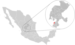
Coordinates: 21°44′15″N 103°28′30″W / 21.7375°N 103.475°WCoordinates: 21°44′15″N 103°28′30″W / 21.7375°N 103.475°W Country  Mexico
State Zacatecas Municipal seat Atolinga Largest city Atolinga Municipality 1917 Government – Municipal President Rodolfo Castro López, PAN Area – Total 280 km2 (108.1 sq mi) Elevation 2,250 m (7,382 ft) Population (2005)[1] – Total 2,738 – Largest city 1,465 Atolinga Time zone CST (UTC-6) Postal Code 99730 Area code(s) 437 Atolinga is one of the 58 municipalities in the state of Zacatecas, Mexico. It is located on the southern part of the state of Zacatecas and is bordered by the municipalities of Tepechitlán and Florencia de Benito Juárez. To the east it is bordered by Tlaltenango de Sánchez Román and to the north and west by the state of Jalisco. The municipality covers a total surface area of 280 square kilometers (110 sq mi)[2].
History
Prior to the arrival of the Spanish to the area, the region around Atolinga was inhabited by indigenous people of the Caxcan and Tepecan ethnic groups. The first Spanish contact with these people must have been in 1530 when Pedro Almíndez Chirino went through the Valley of Tlaltenango on a northbound expedition.
The first land grantee of the area was Pedro Sernosa, who later sold his land to Juan Fernández de Jara Quemada.
The town formed part of the jurisdiccion of Tlaltenango for both ecclesiastical purposes and governmental purposes until the beginning of the 1800s. In 1814, a plea was made by the citizenry that the community be granted its own town council and status as a municipality due to the long distance from the municipal seat and the ascending local population. The plea spells out that the town counted with nearly 700 "souls" and that within a radius of two leagues lived more than 3,700 people.
Population
In the 2005 census Atolinga, reported a population of 2,738.[1] Of these, 1,453 lived in the municipal seat and the remainder lived in surrounding rural communities.
References
- ^ a b Link to tables of population data from Census of 2005 INEGI: Instituto Nacional de Estadística, Geografía e Informática
- ^ "Atolingo", Encyclopedia de Municipios
 State of Zacatecas
Municipalities
and
(municipal seats)Apozol (Apozol) · Apulco (Apulco) · Atolinga (Atolinga) · Florencia de Benito Juárez Municipality (Florencia de Benito Juárez) · Calera de Víctor Rosales Municipality (Víctor Rosales) · Cañitas de Felipe Pescador (Cañitas de Felipe Pescador) · Concepción del Oro (Concepción del Oro) · Cuauhtémoc (San Pedro Piedra Gorda) · Chalchihuites (Chalchihuites) · El Plateado de Joaquín Amaro (El Plateado de Joaquín Amaro) · El Salvador (El Salvador) · Fresnillo (Fresnillo) · Genaro Codina (Genaro Codina) · General Enrique Estrada (General Enrique Estrada) · General Francisco R Murguía (Nieves) · General Pánfilo Natera (General Pánfilo Natera) · Guadalupe (Guadalupe) · Huanusco (Huanusco) · Jalpa (Jalpa) · Jerez de García Salinas (Jerez) · Jiménez del Teul (Jiménez del Teul) · Juan Aldama (Juan Aldama, Zacatecas) · Juchipila (Juchipila) · Loreto (Loreto) · Luis Moya (Luis Moya, Zacatecas) · Mazapil (Mazapil) · Melchor Ocampo (Melchor Ocampo) · Mezquital del Oro (Mezquital del Oro) · Miguel Auza (Miguel Auza, Zacatecas) · Momax (Momax) · Monte Escobedo (Monte Escobedo) · Morelos (Morelos) · Moyahua de Estrada (Moyahua de Estrada) · Nochistlán de Mejía (Nochistlán de Mejía) · Noria de Ángeles (Noria de Ángeles) · Ojocaliente (Ojocaliente) · Pánuco (Pánuco) · Pinos (Pinos) · Río Grande (Río Grande) · Santa María de la Paz (Santa María de la Paz) · Saín Alto (Saín Alto) · Sombrerete (Sombrerete) · Susticacán (Susticacán) · Tabasco (Tabasco) · Tepechitlán (Tepechitlán) · Tepetongo (Tepetongo) · Teúl de González Ortega (Teúl de González Ortega) · Tlaltenango de Sánchez Román · Trancoso (Trancoso) · Trinidad García de la Cadena (Trinidad García de la Cadena) · (Valparaíso) · (Vetagrande) · (Villa de Cos) · (Villa García) · Villa González Ortega Municipality (Villa González Ortega) · (Villa Hidalgo) · (Villanueva) · (Zacatecas)
 Categories:


Wikimedia Foundation. 2010.