- Temozón Municipality
-
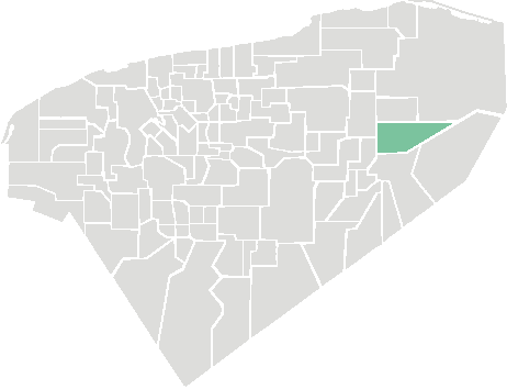
Temozón — Municipality — 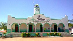 Location of the Municipality
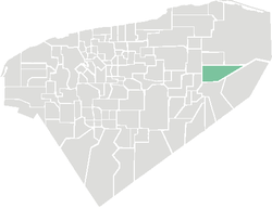 Location of the Municipality
 Temozón
Coordinates: 20°55′N 87°55′W / 20.917°N 87.917°WCoordinates: 20°55′N 87°55′W / 20.917°N 87.917°W Country  Mexico
State  Yucatán
Mexico Ind. 1821 Yucatan Est. 1824 Municipality Est. 1915[1] Government - Type PRI  2007-2010
- Municipal President Carlos Manuel Aguilar Loria[1] Area - Total 1,087.06 km2 (419.7 sq mi) [1] Elevation[1] 22 m (72 ft) Population (2005 [2][3]) - Total 14,008 - Demonym Temozonense Time zone Central Standard Time (UTC-6) - Summer (DST) Central Daylight Time (UTC-5) INEGI Code 085 Major Airport Merida (Manuel Crescencio Rejón) International Airport IATA Code MID ICAO Code MMMD Website Official Website The Municipality of Temozón is one of the 106 subdivisions of the State of Yucatán in Mexico. Its municipal seat is located in the City of Temozón.
Contents
Location
This municipality is located in the eastern region of the state. It is between latitudes 20º 48 'and 20º 57' north and longitudes 87º 47' and 88 º 16' west.[1]
Its northern border is Calotmul - Tizimín, to the south is Valladolid, on the east Chemax and the west Espita and Uayma.[1]
Communities
The municipality is made up of 99 different communities, of which the most important are:[1]
- Temozón (Municipal Center)
- Hunuku
- Nahbalam
- Yokdzonot Presentado
- Santa Rita
Landmarks
Architectural
San Roman Church, built during the colonial period (probably in the eighteenth century). The church of San Antonio de Padua, and the municipal building.[1]
Archeological
References
- ^ a b c d e f g h i "Nuestros municipios - Temozón". http://www.yucatan.gob.mx/estado/municipios/31085a.htm. Retrieved 2009-11-11.
- ^ "Encyclopedia of the Municipalities of Mexico: Yucatan". http://www.e-local.gob.mx/wb2/ELOCAL/EMM_yucatan. Retrieved 2009-11-01.
- ^ Census Results by Locality, 2005 INEGI.
Mérida, Yucatán (capital) Topics 
Metros Larger cities Smaller cities Akil · Tzucacab · Tekit · Halachó · Tecoh · Dzidzantún · Seyé · Buctzotz · Caucel · Conkal · Cacalchén · Celestún · Temax · Temozón · Homún · Dzilam González · Kinchil · Teabo · Sotuta · Panabá · Cholul · Chichimilá · Itzincab · Hoctún · X-Can · Dzan · Pisté · Huhí · Cansahcab · Baca · Chocholá · Opichén · Hocabá · Maní · Chicxulub · Popolá · Komchén · Tetiz · Sucilá · Cuzamá · Timucuy · Ixil · Kimbilá · Kantunil · Sacalum · Tahmek · Telchac Pueblo · Tixpéhual · Santa Elena · Tahdziú · Popolnáh · Tixcacalcupul · Chablecal · Tekantó · Cenotillo · San José Tzal · Dzemul · Chelem
Municipalities Abalá · Acanceh · Akil · Baca · Bokobá · Buctzotz · Cacalchén · Calotmul · Cansahcab · Cantamayec · Celestún · Cenotillo · Chacsinkín · Chankom · Chapab · Chemax · Chicxulub Pueblo · Chichimilá · Chikindzonot · Chocholá · Chumayel · Conkal · Cuncunul · Cuzamá · Dzan · Dzemul · Dzidzantún · Dzilam de Bravo · Dzilam González · Dzitás · Dzoncauich · Espita · Halachó · Hocabá · Hoctún · Homún · Huhí · Hunucmá · Ixil · Izamal · Kanasín · Kantunil · Kaua · Kinchil · Kopomá · Mama · Maní · Maxcanú · Mayapán · Mérida · Mocochá · Motul · Muna · Muxupip · Opichén · Oxkutzcab · Panabá · Peto · Progreso · Quintana Roo · Río Lagartos · Sacalum · Samahil · Sanahcat · San Felipe · Santa Elena · Seyé · Sinanché · Sotuta · Sucilá · Sudzal · Suma · Tahdziú · Tahmek · Teabo · Tecoh · Tekal de Venegas · Tekantó · Tekax · Tekit · Tekom · Telchac Pueblo · Telchac Puerto · Temax · Temozón · Tepakán · Tetiz · Teya · Ticul · Timucuy · Tinúm · Tixcacalcupul · Tixkokob · Tixméhuac · Tixpéhual · Tizimín · Tunkás · Tzucacab · Uayma · Ucú · Umán · Valladolid · Xocchel · Yaxcabá · Yaxkukul · Yobaín
Categories:- Municipalities of Yucatán
- Populated places in Yucatán


Wikimedia Foundation. 2010.