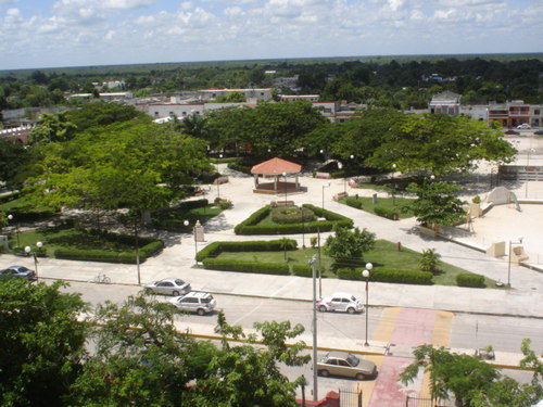
- Dzidzantún
-
Dzidzantún — Town — Mini logo dzidzantun.png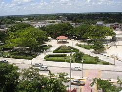 Location of the Municipality in the State of Yucatán
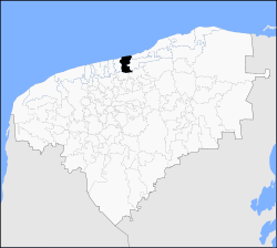 Location of the Municipality in Mexico
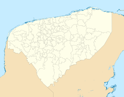
 Dzidzantún
Coordinates: 21°14′50″N 89°2′30″W / 21.24722°N 89.04167°WCoordinates: 21°14′50″N 89°2′30″W / 21.24722°N 89.04167°W Country  Mexico
State  Yucatán
Government – Mayor Álvaro Coral (PRI)[1] Area – Total 198 km2 (76.4 sq mi) [1] Elevation 10 m (33 ft) Population (2005[2][3]) – Total 8,165 – Density 41.2/km2 (106.8/sq mi) – Demonym Dzidzantunence Municipality Time zone Central Standard Time – Summer (DST) Central Daylight Time (UTC) Area code(s) 991 INEGI Code 027 Major Airport Merida (Manuel Crescencio Rejón) International Airport IATA Code MID ICAO Code MMMD Website Official Website Dzidzantún is a town in Mexico in the northeastern Yucatan. Its date of foundation is lost in the past, locked in its history forged by the great men in the majestic church of Santa Clara belonging to the Franciscan Order.
Contents
History
The site where today stands the village of Dzidzantún "What is written in stone," head of the municipality of the same name, belonged to pre-Hispanic times in the province of Ah Kin Chel. Although there are no data on its foundation by the conquerors, there is a document that attests that the year 1549 there was an Encomienda on this site in favor of Mr. Hernán Muñoz Vaquiano. Since the late nineteenth century belonged to Dzidzantún from Temax until 1918 that stands head of the municipality of the same name by agreement of the Organic Law of the State of Yucatan.
Famous Characters
- Eduardo Ojeda Adams
- José del Carmen Domínguez y Zaldivar Composer and songwriter (1900)[1]
- Rosa Sobrino y Sobrino
- Eneida Guerrero Lizama
- José R. Sobrino y Sobrino
- Oscar Filiberto Cruz Sobrino
- Victor Coral Campos
- Diego Méndez Estrada
Location
This municipality is located in the coastal region known as the northern Gulf of Mexico. It falls within the parallel 21° 12' and 21° 23' latitude north and between 88° 57' and 89° 04' west longitude and has an average height of 4 meters.
It is bounded on the north by the Gulf of Mexico, south to the cities of Temax and Cansahcab, east to the town of Dzilam Gonzalez and to the west of the town of Yobaín.
Communities
The municipality is made up of 7 communities the most significant are as follows:
- Dzidzantún (Municipal Seat)
- Santa Clara
Festivals, Dances and Traditions
Popular Festivals
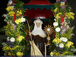 Image of Santa Clara
January, festivities in honor of Santa Clara.
June 10 to June 13, will celebrate the festival in honor of San Antonio de Padua, patron of the people.
August 8 to 14 August, festivities in honor of Santa Clara, patron of the people (August 11).
Run the traditional Fiesta, Tradiciones and CustomsFor All Saints and faithful departed it is customary to place an altar in the place of the main house, which gives the dead the food that they liked: the traditional Mucbil Pollo, accompanied by corn atole again, and chocolate beaten with water. Regional festivals in the dance jaranas people making skills among participants.
Dress
It is the custom for women to use simple Huipil, highlighting the embroidered square neck and cutting edge clothing, this is placed over the shaft, which is subject to a ripple bottom half at the waist with a girdle of the same fabric; fit sandals and sun protection are covered with a shawl. Farmers, especially the elderly, are dressed in baggy trousers, blanket, raw abotonada front shirt, apron Cotia and straw hat.
For major events and Vaquerías women wear a Terno dress, made of fine fabrics, lace and embroidery generally made by hand in cross stitch. This is supplemented with long gold chains, earrings, coral beads or watermark rebozo and Santa Maria.
The men wear white trousers made of cut straight Philippine fine cloth (the rich have been in the garment buttoning gold), hats and sandals Jipijapa, without missing the traditional red scarf bandana popularly known as essential to the Jarana dance.
References
- ^ a b c "Nuestros municipios - Dzidzantún". http://www.yucatan.gob.mx/estado/municipios/31027a.htm. Retrieved 2009-11-11.
- ^ "Encyclopedia of the Municipalities of Mexico: Yucatan". http://www.e-local.gob.mx/wb2/ELOCAL/EMM_yucatan. Retrieved 2009-11-01.
- ^ Census Results by Locality, 2005 INEGI.
Topics 
Metros Larger cities Smaller cities Akil · Tzucacab · Tekit · Halachó · Tecoh · Dzidzantún · Seyé · Buctzotz · Caucel · Conkal · Cacalchén · Celestún · Temax · Temozón · Homún · Dzilam González · Kinchil · Teabo · Sotuta · Panabá · Cholul · Chichimilá · Itzincab · Hoctún · X-Can · Dzan · Pisté · Huhí · Cansahcab · Baca · Chocholá · Opichén · Hocabá · Maní · Chicxulub · Popolá · Komchén · Tetiz · Sucilá · Cuzamá · Timucuy · Ixil · Kimbilá · Kantunil · Sacalum · Tahmek · Telchac Pueblo · Tixpéhual · Santa Elena · Tahdziú · Popolnáh · Tixcacalcupul · Chablecal · Tekantó · Cenotillo · San José Tzal · Dzemul · Chelem
Municipalities Abalá · Acanceh · Akil · Baca · Bokobá · Buctzotz · Cacalchén · Calotmul · Cansahcab · Cantamayec · Celestún · Cenotillo · Chacsinkín · Chankom · Chapab · Chemax · Chicxulub Pueblo · Chichimilá · Chikindzonot · Chocholá · Chumayel · Conkal · Cuncunul · Cuzamá · Dzan · Dzemul · Dzidzantún · Dzilam de Bravo · Dzilam González · Dzitás · Dzoncauich · Espita · Halachó · Hocabá · Hoctún · Homún · Huhí · Hunucmá · Ixil · Izamal · Kanasín · Kantunil · Kaua · Kinchil · Kopomá · Mama · Maní · Maxcanú · Mayapán · Mérida · Mocochá · Motul · Muna · Muxupip · Opichén · Oxkutzcab · Panabá · Peto · Progreso · Quintana Roo · Río Lagartos · Sacalum · Samahil · Sanahcat · San Felipe · Santa Elena · Seyé · Sinanché · Sotuta · Sucilá · Sudzal · Suma · Tahdziú · Tahmek · Teabo · Tecoh · Tekal de Venegas · Tekantó · Tekax · Tekit · Tekom · Telchac Pueblo · Telchac Puerto · Temax · Temozón · Tepakán · Tetiz · Teya · Ticul · Timucuy · Tinúm · Tixcacalcupul · Tixkokob · Tixméhuac · Tixpéhual · Tizimín · Tunkás · Tzucacab · Uayma · Ucú · Umán · Valladolid · Xocchel · Yaxcabá · Yaxkukul · Yobaín
Categories:- Populated places in Yucatán


Wikimedia Foundation. 2010.