Chicxulub, Yucatán

Chicxulub, Yucatán
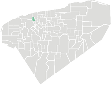
Location of Chicxulub in Yucatán

Chicxulub (Maya pronunciation[tʃʼikʃuluɓ]) is a town, and surrounding municipality of the same name, in the Mexican state of Yucatán.

At the census of 2005, the town had a population of 5,052 people.

Chicxulub is most famous for being near the geographic center of the Chicxulub crater, an impact crater discovered by geologists on the Yucatán Peninsula and extending into the ocean. It was created by the impact of an asteroid or comet some 65 million years ago which may have caused the Cretaceous–Tertiary extinction event. The coastal village (or puerto) of Chicxulub, 6 km east of the nearest town, Progreso, lies almost exactly on the geographic center of the crater.

The name Chicxulub is Yucatec Maya language, where ch’ic means "flea" or "tick", and xulub’ means "devil, demon, or horns".[1]

References

  1. ^ Victoria Bricker, A Dictionary of The Maya Language As Spoken in Hocaba, Yucatan

Coordinates: 21°17′42″N 89°36′18″W / 21.295°N 89.605°W / 21.295; -89.605


Wikimedia Foundation. 2010.

Игры ⚽ Поможем написать курсовую

Look at other dictionaries:

  • Chicxulub — may refer to: Chicxulub crater, on the Yucatán Peninsula, in Mexico Chicxulub, Yucatán, a town This disambiguation page lists articles about distinct geographical locations with the same name. If an internal link …   Wikipedia

  • Chicxulub — Para otros usos de este término, véase Chicxulub (desambiguación). Chicxulub Chicxulub Puerto …   Wikipedia Español

  • Chicxulub (Ville) — Chicxulub blason image Pays   État   Municipalité …   Wikipédia en Français

  • Chicxulub (ville) — Chicxulub Administration Pays  Mexique État État du Yucatán Municipalité Chicxulub …   Wikipédia en Français

  • Chicxulub (desambiguación) — Chicxulub es un topónimo en idioma maya que puede referirse a: Chicxulub Puerto, localidad en el estado de Yucatán, 8 km al oriente del Puerto de Progreso, epicentro del Cráter de Chicxulub; Chicxulub cráter, cráter producto del impacto de un… …   Wikipedia Español

  • Yucatán (Halbinsel) — Yucatán Satellitenaufnahme der Yucatán Halbinsel Gewässer 1 Karibisches Meer Gewässer 2 …   Deutsch Wikipedia

  • Yucatan — Yucatán Pour les articles homonymes, voir Yucatán (homonymie). Estado Libre y Soberano de Yucatán (État libre et souverain du Yucatán) …   Wikipédia en Français

  • Chicxulub — es un pueblo del estado de Yucatán, México, localizado en las coordenadas . La población en 2000 era de aproximadamente 3.400 personas. El pueblo vive de la pesca y el turismo. La ciudad fue fundada por los Pech, señores de Chicxulub y Conkal. En …   Enciclopedia Universal

  • Chicxulub-Krater — Der Chicxulub Krater nach Messungen der Schwereanomalie 21.297222222222 89.594444444444 Koordinaten …   Deutsch Wikipedia

  • Chicxulub crater — Imaging from NASA s Shuttle Radar Topography Mission STS 99 reveals part of the 180 kilometer (112 mi) diameter ring of the crater; clustered around the crater s trough are numerous sinkholes, suggesting a prehistoric oceanic basin in… …   Wikipedia

Share the article and excerpts

Direct link
Do a right-click on the link above
and select “Copy Link”