- Tzucacab Municipality
-
Tzucacab — Municipality — Location of the Municipality Location of the Municipality
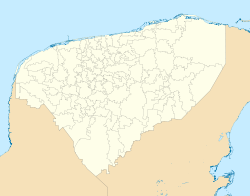
 Tzucacab
Coordinates: 20°04′N 89°02′W / 20.067°N 89.033°WCoordinates: 20°04′N 89°02′W / 20.067°N 89.033°W Country  Mexico
State  Yucatán
Mexico Ind. 1821 Yucatan Est. 1824 Municipality Est. 1918 [1] Government – Municipal President Efren Estrada Mario Camara[1] Area – Total 1,289 km2 (497.7 sq mi) [1] Elevation 36 m (118 ft) Population (2005 [2][3]) – Total 13,564 Time zone Central Standard Time (UTC-6) – Summer (DST) Central Daylight Time (UTC-5) Postal Code INEGI Code 098 Major Airport Merida (Manuel Crescencio Rejón) International Airport IATA Code MID ICAO Code MMMD Website Official Website The Municipality of Tzucacab is one of the 106 subdivisions of the State of Yucatán in Mexico. Its municipal seat is located in the City of Tzucacab.
Contents
Location
Tzucacab municipality is located in the southern region of the state and falls between latitudes 19º 38'and 20º 09' north and longitudes 88º 59' and 89° 14' west.[1]
Communities
The municipality is made up of 40 different communities, of which the most important are:[1]
- Tzucacab (Municipal Seat)
- Catmis
- Ekbalam
- Corral
- Noh-Bec
Architectural Landmarks
The Church of St. Francis Xavier, located in the municipal seat Tzucacab and dating from the colonial era.[1]
References
- ^ a b c d e f "Nuestros municipios - Tzucacab". http://www.yucatan.gob.mx/estado/municipios/31098a.htm. Retrieved 2009-11-11.
- ^ "Encyclopedia of the Municipalities of Mexico: Yucatan". http://www.e-local.gob.mx/wb2/ELOCAL/EMM_yucatan. Retrieved 2009-11-01.
- ^ Census Results by Locality, 2005 INEGI.
Topics 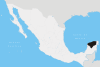
Metros Larger cities Smaller cities Akil · Tzucacab · Tekit · Halachó · Tecoh · Dzidzantún · Seyé · Buctzotz · Caucel · Conkal · Cacalchén · Celestún · Temax · Temozón · Homún · Dzilam González · Kinchil · Teabo · Sotuta · Panabá · Cholul · Chichimilá · Itzincab · Hoctún · X-Can · Dzan · Pisté · Huhí · Cansahcab · Baca · Chocholá · Opichén · Hocabá · Maní · Chicxulub · Popolá · Komchén · Tetiz · Sucilá · Cuzamá · Timucuy · Ixil · Kimbilá · Kantunil · Sacalum · Tahmek · Telchac Pueblo · Tixpéhual · Santa Elena · Tahdziú · Popolnáh · Tixcacalcupul · Chablecal · Tekantó · Cenotillo · San José Tzal · Dzemul · Chelem
Municipalities Abalá · Acanceh · Akil · Baca · Bokobá · Buctzotz · Cacalchén · Calotmul · Cansahcab · Cantamayec · Celestún · Cenotillo · Chacsinkín · Chankom · Chapab · Chemax · Chicxulub Pueblo · Chichimilá · Chikindzonot · Chocholá · Chumayel · Conkal · Cuncunul · Cuzamá · Dzan · Dzemul · Dzidzantún · Dzilam de Bravo · Dzilam González · Dzitás · Dzoncauich · Espita · Halachó · Hocabá · Hoctún · Homún · Huhí · Hunucmá · Ixil · Izamal · Kanasín · Kantunil · Kaua · Kinchil · Kopomá · Mama · Maní · Maxcanú · Mayapán · Mérida · Mocochá · Motul · Muna · Muxupip · Opichén · Oxkutzcab · Panabá · Peto · Progreso · Quintana Roo · Río Lagartos · Sacalum · Samahil · Sanahcat · San Felipe · Santa Elena · Seyé · Sinanché · Sotuta · Sucilá · Sudzal · Suma · Tahdziú · Tahmek · Teabo · Tecoh · Tekal de Venegas · Tekantó · Tekax · Tekit · Tekom · Telchac Pueblo · Telchac Puerto · Temax · Temozón · Tepakán · Tetiz · Teya · Ticul · Timucuy · Tinúm · Tixcacalcupul · Tixkokob · Tixméhuac · Tixpéhual · Tizimín · Tunkás · Tzucacab · Uayma · Ucú · Umán · Valladolid · Xocchel · Yaxcabá · Yaxkukul · Yobaín
Categories:- Municipalities of Yucatán
- Populated places in Yucatán


Wikimedia Foundation. 2010.