- Maker
-
Coordinates: 50°20′42″N 4°11′28″W / 50.3451°N 4.1911°W
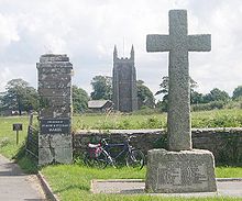
For other uses, see Make (disambiguation).Maker (Cornish: Magor) is a village between Cawsand and Rame Head, situated on the Rame Peninsula, in Cornwall, United Kingdom.
The name means a ruin in Cornish, but another Celtic name is Egloshayle, (not to be confused with Egloshayle on the River Camel) which means, the church on the estuary, a very apt description of the church's location.
The village and its neighbour Rame are in the civil parish of Maker with Rame and the parliamentray consituency of South East Cornwall.
Contents
History
In their western advance across England, the Anglo-Saxons halted at the Tamar, but in 705, King Geraint of Cornwall gave the promontory on the Cornish side of the mouth of the Tamar to Sherborne Abbey, to keep control of the Tamar mouth in Saxon hands. This was royal land, and remained in Devon until 1844.The Normans installed the Valletorts as tenants of most of the land controlling the Tamar. From them, Maker passed by marriage to the Durnford family and then to the Edgcumbe family.
Parish church
The church of St Julian is a typical 15th century Cornish church. It was a time of rebuilding throughout the country and churches were designed for preaching the word rather than stressing the liturgy. The aisles are the same length as the nave, and there is a massive western tower. The font is Norman, but was originally at St Merryn.[1] The Edgcumbe chapel was added in 1874.
Notable residents
- William Hughes (writer), barrister and writer, was born here
References
- ^ Cornish Church Guide (1925) Truro: Blackford
External links
 Media related to Maker at Wikimedia CommonsCategories:
- Villages in Cornwall
- Cornwall geography stubs
Wikimedia Foundation. 2010.

