- McColly Covered Bridge
-
McColly Covered Bridge
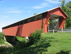
 Eastern end of the bridge
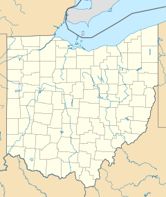
Location: County Road 13 southeast of Bloom Center in Washington Township, Logan County, Ohio Coordinates: 40°24′3″N 83°55′27″W / 40.40083°N 83.92417°WCoordinates: 40°24′3″N 83°55′27″W / 40.40083°N 83.92417°W Area: less than one acre Built: 1876 Architect: Anderson Green Co.; T.B. Stillwell Architectural style: Howe truss covered bridge Governing body: Local NRHP Reference#: 75001458[1] Added to NRHP: May 28, 1975 The McColly Covered Bridge is a historic wooden covered bridge in western Logan County, Ohio, United States. Located in Washington Township near the community of Bloom Center,[2] it is one of two remaining covered bridges in Logan County.[3] It carries County Road 13 (formerly called the "Covered Bridge Pike"[4]) over the Great Miami River, approximately 5 miles (8.0 km) south of its source at Indian Lake.[2]
The bridge was built in 1876 by the Anderson Green Company of Sidney, Ohio at a cost of $3,103 and named for nearby landowner Nicholas McColly.[5]:3 Although Anderson Green built many other bridges statewide, including another bridge in southwestern Logan County, it is the only remaining bridge built by the company in any location.[6] It is approximately 142 feet (43 m) long, with a clearance of 16 feet (4.9 m) and a total width of 20 feet (6.1 m).[5]:2
In 1974, the McColly Bridge was added to the National Register of Historic Places for its significance in Ohio's history.[1][5]:4 At that time, it was one of only eighteen remaining Howe truss bridges in Ohio.[5]:3 Although the nomination assessed its condition at "good," by the 1990s, the number of Howe truss bridges nearly fell to seventeen, as the McColly Bridge had deteriorated to the point that an engineering survey in 1996 pronounced it to be in imminent danger of collapse.[7]
Restorations in 1943 and 1958 involved replacement of floorboards, strengthening of trusses, and raising the bridge to reduce the danger of flooding.[6] Despite these repairs, the county closed the bridge in July 1993 due to structural deterioration from vandalism and recent floods.[8] The 1996 engineering summary identified several serious faults: the bridge had tilted so that its portals were no longer square, many of the beams had rotted, a collision had damaged the interior, and nearly one-third of the bridge's siding had disappeared.[7] In early 2000, the Amos B. Schwartz Construction Company of Geneva, Indiana was hired to repair the bridge, and it was reopened on November 14, 2000,[9] ten months and over $690,000 after the commencement of repairs. The Ohio Department of Transportation and the Federal Highway Administration provided aid for this project and recognized it as "an outstanding example of preservation, rehabilitation and reuse of a historic bridge."[10]
References
- ^ a b "National Register Information System". National Register of Historic Places. National Park Service. 2009-03-13. http://nrhp.focus.nps.gov/natreg/docs/All_Data.html.
- ^ a b DeLorme. Ohio Atlas & Gazetteer. 7th ed. Yarmouth: DeLorme, 2004, 56. ISBN 0-89933-281-1.
- ^ Ohio's Covered Bridges, Ohio Department of Transportation, Office of Structural Engineering. Accessed 2009-09-26.
- ^ "Covered Bridges Etched by Time and Weather". Johnson, James R. Springfield News-Sun, 1979-09-09.
- ^ a b c d Wood, Miriam F. National Register of Historic Places Inventory/Nomination: McColly Covered Bridge. National Park Service, 1974-07-17.
- ^ a b Mast, Joel E. "McColly bridge ready for another century: Logan County's 134-year-old structure to reopen soon". Bellefontaine Examiner, 2000-10-12, 1/4.
- ^ a b Burgess & Niple Engineers Architects. "Engineering Summary Report". Bellefontaine: Logan County Engineer's Office, June 1997.
- ^ Bair, Miriam. "Historical landmark restoration approaches: Bids received for McColly covered bridge project". Bellefontaine Examiner, 1999-11-02.
- ^ Loehr, Doug. "McColly Covered Bridge reopens with ceremony". Bellefontaine Examiner, 2000-11-15.
- ^ Mast, Joel E. "County recognized for preservation effort". Bellefontaine Examiner, 2000-10-14.
Further reading
- Allen, Richard S. Covered Bridges of the Middle West. Brattleboro: Stephen Greene, 1970.
- Ketcham, Bryan E. Covered Bridges on the Byways of Ohio. Oxford: Oxford, 1969.
External links
National Register of Historic Places in Logan County, Ohio Historic district Lake Ridge Island Mounds

Other properties Dunns Pond Mound | First Concrete Street in U.S. | William Lawrence House | Logan County Courthouse | Martin Marmon House | McColly Covered Bridge | Abram S. Piatt House and Donn S. Piatt House | Schine's Holland Theatre
U.S. National Register of Historic Places Topics Lists by states Alabama • Alaska • Arizona • Arkansas • California • Colorado • Connecticut • Delaware • Florida • Georgia • Hawaii • Idaho • Illinois • Indiana • Iowa • Kansas • Kentucky • Louisiana • Maine • Maryland • Massachusetts • Michigan • Minnesota • Mississippi • Missouri • Montana • Nebraska • Nevada • New Hampshire • New Jersey • New Mexico • New York • North Carolina • North Dakota • Ohio • Oklahoma • Oregon • Pennsylvania • Rhode Island • South Carolina • South Dakota • Tennessee • Texas • Utah • Vermont • Virginia • Washington • West Virginia • Wisconsin • WyomingLists by territories Lists by associated states Other Categories:- Bridges completed in 1876
- Covered bridges in Ohio
- Buildings and structures in Logan County, Ohio
- Bridges on the National Register of Historic Places in Ohio
- Truss bridges
- Wooden bridges in the United States
- Transportation in Logan County, Ohio
- Visitor attractions in Logan County, Ohio
- Road bridges in Ohio
Wikimedia Foundation. 2010.

