- Dauphin Island Air Force Station
-
Dauphin Island Air Force Station 
Part of Air Defense Command (ADC) Type Air Force Station Coordinates 30°15′01″N 088°04′42″W / 30.25028°N 88.07833°W Location code ADC ID: TM-196, NORAD ID: Z-196, Z-249 Built 1958 In use 1958-1974 Controlled by  United States Air Force
Garrison 693d Aircraft Control and Warning (later Radar) Squadron
635th Aircraft Control and Warning (later Radar) Squadron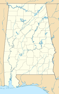
 Dauphin Island AFSLocation of Dauphin Island AFS, Alabama
Dauphin Island Air Force Station is a closed United States Air Force General Surveillance Radar station. It is located 1.9 miles (3.1 km) east of Dauphin Island, Alabama. It was closed in 1980.
Beginning in September 1982, the Federal Aviation Administration (FAA) acquired part of the facility. Today the site is part of the Joint Surveillance System (JSS), designated by NORAD as Eastern Air Defense Sector (EADS) Ground Equipment Facility J-12 with an ARSR-2 radar.
Contents
History
Dauphin Island Air Force Station came into existence as part of Phase III of the Air Defense Command Mobile Radar program. On October 20, 1953 ADC requested a third phase of twenty-five radar sites be constructed.
The 693d Aircraft Control and Warning Squadron was assigned to the station on 1 September 1958. The site had an AN/FPS-20 search radar and two AN/FPS-6A height-finder radars, and initially the station functioned as an aircraft control and warning station.
The Ground Air Transmitting Receiving (GATR) Site for communications was located at 30°14′47″N 088°04′56″W / 30.24639°N 88.08222°W, approximately 0.4 mile southeast from the main site. Normally the GATR site was connected by a pair of buried telephone cables, with a backup connection of dual telephone cables overhead. The Coordinate Data Transmitting Set (CDTS) (AN/FST-2) at the main site converted each radar return into a digital word which was transmitted by the GATR via microwave to the Control center.
Dauphin Island AFS began operating an AN/FPS-7 radar in 1960, and joined the Semi Automatic Ground Environment (SAGE) system, feeding data to DC-09 at Gunter AFB, Alabama. After joining, the squadron was re-designated as the 693d Radar Squadron (SAGE) on 1 March 1961. The radar squadron provided information 24/7 the SAGE Direction Center where it was analyzed to determine range, direction altitude speed and whether or not aircraft were friendly or hostile. On 31 July 1963, the site was redesignated as NORAD ID Z-196.
In 1961 Dauphin Island AFS became a joint-use facility with the Federal Aviation Administration (FAA). However, it was removed from joint-use status in 1962 and then put back in joint-use status in 1963. A second radar squadron, the 635th Radar Squadron, arrived from Fort Lawton, Washington on 1 January 1963. This unit operated an AN/FPS-93 and an AN/FPS-6 radar. In 1965, the site was again removed from joint-use status.
Over the years, the equipment at the station was upgraded or modified to improve the efficiency and accuracy of the information gathered by the radars. The Air Force deactivated the 693d on 30 September 1970. In 1972, Dauphin Island became part of the Southern Air Defense Systems (SADS). It was given a new NORAD designation, Z-249. The 635th was deactivated on July 1, 1974.
The radar site became Operating Location G, 630th Radar Squadron, which inactivated on 31 December 1977. It then became Operating Location E, 678th Air Defense Group. The site closed for good on 30 September 1980.
Today the station is the Dauphin Island Sea Lab, Alabama's primary marine education and research center. Part of the station also is used by the United States Coast Guard as a recreational facility. Most of the USAF buildings have found new uses, and several radar towers have been re-purposed.
See also
- List of USAF Aerospace Defense Command General Surveillance Radar Stations
- List of United States Air Force aircraft control and warning squadrons
References
 This article incorporates public domain material from websites or documents of the Air Force Historical Research Agency.
- A Handbook of Aerospace Defense Organization 1946 - 1980, by Lloyd H. Cornett and Mildred W. Johnson, Office of History, Aerospace Defense Center, Peterson Air Force Base, Colorado
- Winkler, David F. (1997), Searching the skies: the legacy of the United States Cold War defense radar program. Prepared for United States Air Force Headquarters Air Combat Command.
- Dauphin Island AFS, AL
External links
Bases CONUSAdair · Beale · Bong (unbuilt) · Charleston · Davis-Monthan · Dobbins · Dover · Dow · Duluth · England · Ent · Ethan Allen · Fairfax · Fort Lee · Geiger · George · Glasgow · Grand Forks · Grenier · Griffiss · Gunter · Hamilton · Hancock · Homestead · Hurlburt · Imeson · K.I. Sawyer · Kincheloe · Kingsley · Kirtland · Larson · Luke · March · Malmstrom · McCoy · McChord · McClellan · McGhee Tyson · McGuire · Minneapolis-St. Paul · Minot · Mitchel · New Castle · Niagara Falls · Norton · O'Hare · Oklahoma City · Otis · Oxnard · Paine · Perrin · Peterson · Pittsburgh · Pope · Portland · Presque Isle · Richards-Gebaur · Selfridge · Seymour Johnson · Sioux City · Snelling · Stead · Stewart · Suffolk County · Tinker · Travis · Truax · Tyndall · Vandenburg · Webb · Westover · Willow Run · Wright-Patterson · Wurtsmith · Youngstown
OverseasErnest Harmon · Frobisher Bay · Goose Bay · Keflavik · Pepperrell · Thule · Topsham

Stations CONUSAlmaden · Charleston · Clear · Cross City · Benton · Empire · Mill Valley · Montauk · Mount Hebo · North Truro · Point Arena · Rye · Thomasville · Watertown
OverseasAlbrook
Air
Defense
unitsForcesAir
DivisionsSectorsAlbuquerque · Bangor · Boston · Chicago · Detroit · Duluth · Goose · Grand Forks · Great Falls · Iceland · Kansas City · Los Angeles · Minot · Montgomery · New York · Oklahoma City · Phoenix · Portland · Reno · Sault Sainte Marie · San Francisco · Seattle · Sioux City · Spokane · Stewart · Syracuse · Washington
WingsGroups1st · 4th · 10th · 14th · 15th · 23rd · 32nd · 33rd · 50th · 52nd · 53rd · 54th · 56th · 57th · 73rd · 78th · 79th · 81st · 82nd · 84th · 325th · 326th · 327th · 328th · 329th · 337th · 355th · 408th · 412th · 414th · 473rd · 475th · 476th · 478th · 500th · 501st · 502d · 503d · 507th · 514th · 515th · 516th · 517th · 518th · 519th · 520th · 521st · 525th · 527th · 528th · 529th · 530th · 533d · 534th · 564th · 566th · 567th · 568th · 575th · 678th · 701st · 4676th · 4700th · 4721st · 4722d · 4727th · 4728th · 4729th · 4730th · 4731st · 4732d · 4733d · 4734th · 4735th · 4756th
SquadronsAerospace Defense Command Fighter Squadrons · Aircraft Control and Warning Squadrons
Major
weapon
systemsElectronicFightersMissiles1 · 2 · 3 · 4 · 5
ShipsGuardian · Interceptor · Interdictor · Interpreter · Investigator · Locator · Lookout · Outpost · Pickett · Protector · Scanner · Searcher · Skywatcher · Tracer · Watchman · Vigil
Miscellaneous Categories:- SAGE sites
- Radar stations of the United States Air Force
- Closed facilities of the United States Air Force
- Military facilities in Alabama
- Aerospace Defense Command

Wikimedia Foundation. 2010.