- Dabbahu Volcano
-
Dabbahu Volcano 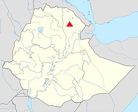
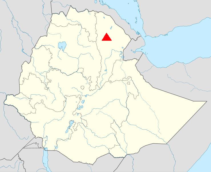
Location of the Dabbahu Volcano within EthiopiaElevation 1,442 m (4,731 ft) [1] Listing List of volcanoes in Ethiopia Location Location Afar Depression, Afar Region, Ethiopia Coordinates 12°36′N 40°29′E / 12.6°N 40.48°E[1] Geology Type Stratovolcano Last eruption September 26, 2005 Dabbahu Volcano (also Boina, Boyna or Moina) is a volcano located in the remote Afar Region of Ethiopia. This stratovolcano[2] is part of the Afar Triangle (Afar Depression), a highly active volcanic region which includes Erta Ale.[1] An eruption on September 26, 2005 created a large fissure in the ground, known as the Dabbahu fissure.[3]
Contents
2005 Eruption
The only eruption of the volcano in recorded history occurred on September 26, 2005. Preceding the eruption, the ground swelled and an earthquake swarm consisting of over 130 events occurred.[2] Earthquakes measured 4.2 on the Richter scale.[4] The eruption began 5 kilometers northeast of the summit. Ash from the eruption darkened the area surrounding the volcano for nearly 3 days.
The eruption formed a 60 km (37 mi) long fissure and a 30 m (98 ft) wide pumice cone at the fissure's southern end. Ash reached as far as the administrative center of Teru, located 40 km (25 mi) southwest of the volcano.
Plate tectonics
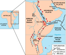

The volcano is located along the Somali Plate. Researchers predict that the land along this region, known as the Great Rift Valley, will eventually break away, creating a new island consisting of eastern Ethiopia and Djibouti with a new sea in between.[5][6] Using seismic data from 2005, a research study predicted that this new ocean would likely be formed in about one million years.[7]
Life
Scientists are studying the fissure for extremophiles.[8]
See also
References
- ^ a b c "Dabbahu Volcano". http://www.volcanolive.com/dabbahu.html. Retrieved 30 August 2009.
- ^ a b 2009-11-04 "Dabbahu: Monthly Reports". Global Volcanism Program, Smithsonian Institution. http://www.volcano.si.edu/world/volcano.cfm?vnum=accessed 2009-11-04.
- ^ "Inside the Hottest Place on Earth". BBC News. 2009-03-19. http://news.bbc.co.uk/2/hi/science/nature/7950845.stm. Retrieved August 30, 2009.
- ^ "Quake triggers volcanic eruption in Ethiopia". http://friendsofethiopia.blogspot.com/2005/10/quake-triggers-volcanic-eruption-in.html. Retrieved 30 August 2009.
- ^ "Scientists: New Ocean Forming in Ethiopia". Fox News. 2005-12-10. http://www.foxnews.com/story/0,2933,178332,00.html. Retrieved August 30, 2009.
- ^ "Geologists have ringside seats for an ocean's birth". The Register. http://www.theregister.co.uk/2006/07/20/ocean_birth/. Retrieved 30 August 2009.
- ^ "Giant crack in Africa may create a new ocean". MSNBC. http://www.msnbc.msn.com/id/33605604/ns/technology_and_science-science/. Retrieved 8 November 2009.
- ^ "The Birth of an Ocean in the Hottest Desert on Earth". http://issuu.com/lightmediation/docs/birthofanocean?mode=embed&documentId=080419174234-ff3ffaf5e5a946daabe276d7b37ce6a1&layout=grey. Retrieved 30 August 2009.
Sovereign
states- Algeria
- Angola
- Benin
- Botswana
- Burkina Faso
- Burundi
- Cameroon
- Cape Verde
- Central African Republic
- Chad
- Comoros
- Democratic Republic of the Congo
- Republic of the Congo
- Côte d'Ivoire (Ivory Coast)
- Djibouti
- Egypt
- Equatorial Guinea
- Eritrea
- Ethiopia
- Gabon
- The Gambia
- Ghana
- Guinea
- Guinea-Bissau
- Kenya
- Lesotho
- Liberia
- Libya
- Madagascar
- Malawi
- Mali
- Mauritania
- Mauritius
- Morocco
- Mozambique
- Namibia
- Niger
- Nigeria
- Rwanda
- São Tomé and Príncipe
- Senegal
- Seychelles
- Sierra Leone
- Somalia
- South Africa
- South Sudan
- Sudan
- Swaziland
- Tanzania
- Togo
- Tunisia
- Uganda
- Zambia
- Zimbabwe
States with limited
recognition- Sahrawi Arab Democratic Republic
- Somaliland
Dependencies and
other territories- Canary Islands / Ceuta / Melilla / Plazas de soberanía (Spain)
- Madeira (Portugal)
- Mayotte / Réunion (France)
- Saint Helena / Ascension Island / Tristan da Cunha (United Kingdom)
- Western Sahara
Categories:- Afar Region
- Stratovolcanoes
- Volcanoes of Ethiopia
- Volcanoes of the Great Rift Valley

Wikimedia Foundation. 2010.