- Afar Triangle
-
For other uses, see Afar (disambiguation).
Coordinates: 11°30′N 41°00′E / 11.5°N 41.0°E
 Location of the triangle (the shaded area in the center of the map) and the local fault lines.
 MODIS satellite image of the Afar Depression and surrounding regions of the Red Sea, Gulf of Aden, Arabia, and the Horn of Africa.
The Afar Triangle (also called the Afar Depression or the Danakil Depression) is a geological depression that is caused by the Afar Triple Junction which is part of the Great Rift Valley. It overlaps Eritrea, Djibouti and the entire Afar Region of Ethiopia. The Afar Triangle includes the Danakil Depression and the lowest point in Africa, Lake Asal (155 metres / 509 feet below sea level). Only the Awash River flows into the area, where it ends in a chain of lakes that increase in salinity. Dallol is also part of the depression, one of the hottest places year-round anywhere on Earth. The climate varies from around 25 °C (77 °F) during the rainy season (September–March) to 48 °C (118 °F) during the dry season (March–September).
Afar is well known as one of the cradles of hominids, containing the Middle Awash, site of many fossil hominid discoveries such as Ardi, (Ardipithecus ramidus); the Gona (Gawis cranium), site of the world's oldest stone tools; and Hadar, site of Lucy, the fossilized specimen of Australopithecus afarensis.
Contents
Environment
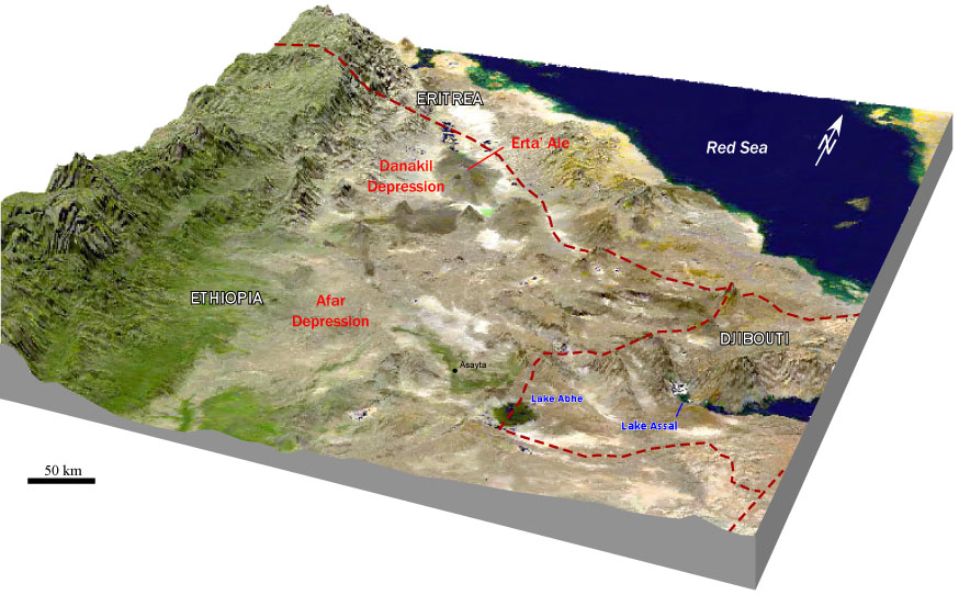
 Perspective view of the Afar depression and environs, generated by draping a Landsat image over a Digital elevation model
The lowlands of the Afar Depression are affected by heat and drought. There is no rain for most of the year, and yearly rainfall averages range from 100 to 200 millimetres (4 to 7 in), with less rain falling closer to the coast. The Awash River, flowing north-eastward through southern Afar, provides a narrow green belt and enables life for the flora and fauna in the area and for the Afars, the nomadic people living in the Danakil desert. About 128 kilometres (80 mi) from the Red Sea, the Awash ends in a chain of salt lakes, where its water evaporates as quickly as it is supplied. About 1,200 km2 (460 sq mi) of the Afar Depression is covered by salt, and salt mining is still a major source of income for many Afar tribes.
The Afar Depression biome is characterized as desert scrubland. Vegetation is mostly confined to drought-resistant plants such as small trees (e.g. species of the dragon tree), shrubs, and grasses. Wildlife includes many herbivores such as Grevy's Zebra, Soemmering’s Gazelle, Oryx Beisa and, notably, the last viable population of African wild ass (Equus africanus somalicus). Birds include the ostrich, the endemic Archer's lark (Heteromirafra archeri), the Secretary Bird, Arabian and Kori bustards, Abyssinian Roller and Crested Francolin. In the southern part of the plain, in Ethiopia, lies the Mille-Sardo Wildlife Reserve (established 1973). Many fossils have been found in the Awash region, not only hominids but also elephantoids, crocodiles and hippopotamus.
Geology
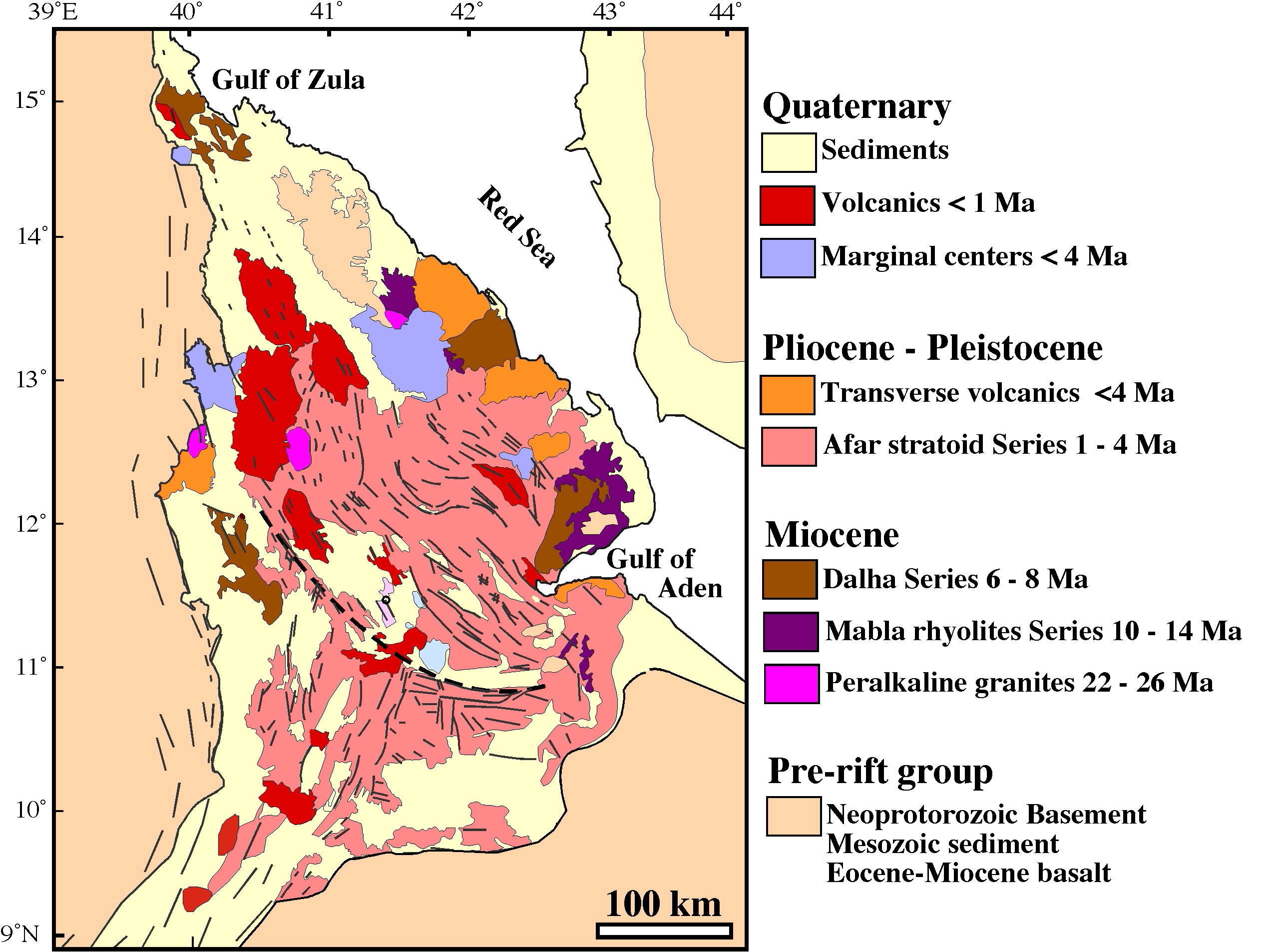
See also: Afar Triple Junction and Plate Tectonics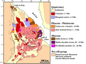 Simplified geologic map of the Afar Depression.
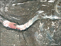 Satellite image of a graben in the Afar Depression.
The Afar Depression is the product of a tectonic triple junction (the Afar Triple Junction), where the spreading ridges that form the Red Sea and the Gulf of Aden emerge on land and meet the East African Rift. The central meeting place for these three pieces of Earth's crust is around Lake Abbe. The Afar Depression is one of two places on Earth where a mid-ocean ridge can be studied on land, the other being Iceland.
In the Depression, the Earth's crust is slowly rifting apart at a rate of 1–2 centimetres (0.4–0.8 in) per year along each of the three rifts which form the "legs" of the triple junction. The immediate consequence of this is that there are (as of late 2005[update]) a continuous sequence of earthquakes, fissures hundreds of metres long and deep appearing in the ground, and the valley floor sinking as much as 100 metres. Between September and October 2005, 163 earthquakes of magnitudes greater than 3.9 and a volcanic eruption occurred within the Afar rift. 2.5 cubic kilometers of molten rock was injected into the plate along a dyke between depths of 2 and 9 km, forcing open an 8 meter wide gap on the surface.[1] Related eruptions have taken place in Teru and Aura woredas. The rift has recently been recorded by means of three-dimensional laser mapping.[2]
Over millions of years, geologists expect the Red Sea to erode through the highlands surrounding the Afar Depression and flood the valley. In about 10 million years, geologists predict that the whole 6,000 km length of the East African Rift will be submerged, forming a new sea as large as the Red Sea is now. At that point, Africa will have lost its Horn.[3]
The floor of the Afar Depression is composed of lava, mostly basalt. One of Earth's five lava lakes, Erta Ale is found here, as well as Dabbahu Volcano. The Afar Depression is, in the views of some geologists, underlain by a mantle plume, a great upwelling of mantle that melts to yield basalt as it approaches the surface.
See also
- Horst
- Lake Assal in Djibouti
- List of fossil sites (with link directory)
- List of hominina (hominid) fossils (with images)
- The Afar people who inhabit the region
References
Notes
- ^ Wright, TJ; Ebinger, C; Biggs, J; Ayele, A; Yirgu, G; Keir, D; Stork, A; et al. (July 2006). "Magma-maintained rift segmentation at continental rupture in the 2005 Afar dyking episode". Nature 442 (7100): 291–294. doi:10.1038/nature04978. PMID 16855588.
- ^ Hottest Place On Earth, Episode 1 at bbc.co.uk
- ^ Bojanowski 2006
Bibliography
- Barberi, F.; Borsi, S.; Ferrara, G.; Marinelli, G.; Santacroce, R.; Tazieff, H.; Varet, J. (1972). "Evolution of the Danakil Depression (Afar, Ethiopia) in Light of Radiometric Age Determinations". Journal of Geology 80 (6): 720–729. doi:10.1086/627797.
- Beyene, Alebachew & Abdelsalam, Mohamed G. (2005). "Tectonics of the Afar Depression: A review and synthesis". Journal of African Earth Sciences 41 (1–2): 41–59. doi:10.1016/j.jafrearsci.2005.03.003.
- Bojanowski, Axel (2006-03-15). "Africa's New Ocean: A Continent Splits Apart". Spiegel Online. http://www.spiegel.de/international/spiegel/0,1518,405947,00.html. Retrieved 2006-03-16. Includes a photo essay of the region and its geologic changes.
- Kloos, Helmut (1982). "Development, drought and famine in the Awash valley of Ethiopia". African Studies Review 25 (4): 21–48. doi:10.2307/524399. JSTOR 524399.
- World Wildlife Fund (2001). "Ethiopian xeric grasslands and shrublands (AT1305)". http://www.worldwildlife.org/wildworld/profiles/terrestrial/at/at1305_full.html.
External links
- The Ethiopian state of Afar: Topography and Climate
- (French) Photos of Erta Ale, Hotsprings at Dallol and Danakil
- (German) Huge collection of (3000) photos from different expeditions in the Dallol, Erta Ale and Danakil regions
- (French) Photos of Afar Depression: between Ethiopia and Djibouti
- (English) Web site of Main Ethiopian Rift
- Science news: Death of a Continent, Birth of an Ocean
Major African geological formations Tectonic plates Cratons and Shields Arabian-Nubian Shield · Congo craton · Kaapvaal craton · Kalahari craton · Saharan Metacraton · Tanzania craton · Tuareg Shield · West African craton · Zimbabwe cratonShear zones Aswa Dislocation · Broodkop Shear Zone · Central African Shear Zone · Chuan Shear Zones · Foumban Shear Zone · Mwembeshi Shear Zone · Todi Shear Zone · Western Meseta Shear ZoneRifts Afar Depression · Anza trough · Bahr el Arab rift · Benue Trough · Blue Nile rift · East African Rift · Gulf of Suez Rift · Lamu Embayment · Melut Basin · Muglad Basin · Red Sea Rift · Atbara rift · White Nile riftSedimentary basins Angola Basin · Blue Nile Basin · Chad Basin · Congo Basin · Douala Basin · Foreland Karoo Basin · Gabon Basin · Iullemmeden Basin · Kufra Basin · Murzuq Basin · Niger Delta Basin · Ogaden Basin · Orange River basin · Owambo Basin · Reggane Basin · Rio del Rey Basin · Sirte Basin · Somali Coastal Basin · Taoudeni basin · Tanzania Coastal Basin · Tindouf BasinMountain ranges Aïr Mountains · Atlas Mountains · Aurès Mountains · Bambouk Mountains · Blue Mountains · Cameroon line · Central Pangean Mountains · Chaillu Mountains · Drakensberg · Ethiopian highlands · East African mountains · Great Escarpment · Great Karas Mountains · Guinée forestière · Imatong Mountains · Jebel Uweinat · Loma Mountains · Mandara Mountains · Marrah Mountains · Mitumba Mountains · Nuba Mountains · Rwenzori Mountains · Sankwala Mountains · Serra da Leba · Serra da Chela · Teffedest Mountains · Tibesti MountainsCategories:- Landforms of Djibouti
- Landforms of Eritrea
- Landforms of Ethiopia
- Afar Region


Wikimedia Foundation. 2010.