- Aurès Mountains
-
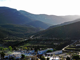
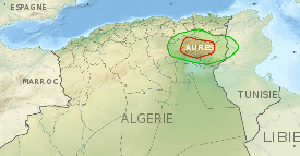
Aurès Mountains Eastern Atlas Mountain range Hammam Essalhine Mont ViewCountries Algeria, Tunisia Regions Batna, Tebessa, Khenchela, Oum El Bouaghi, Souk Ahras, Biskra, Kasserine Part of Atlas Mountains Highest point Djebel Chélia - location Algeria - elevation 7,638 ft (2,328 m) - coordinates 35°19′05″N 6°38′13″E / 35.31806°N 6.63694°E The Aurès (Tamaziɣt: Awras; Latin: Aurasium,[1] Arabic: جبال الأوراس), or Aurea, refers to an Amazigh language-speaking region in East Algeria, as well as an extension of the Atlas mountain range that lies to the east of the Saharan Atlas in eastern Algeria and northwestern Tunisia. Not as tall as the Grand Atlas Mountains of Morocco, the Aurès mountains are far more imposing than the Tell Atlas range that runs closer to the coast. The highest peak, at 2328 m, is the Djebel Chélia in Khenchela Province.
Standing alone in eastern Algeria, the Aurès mountains represent one of the less developed areas in the Maghreb. The Shawia (eastern Berber) population practices traditional transhumance, farming fixed stone terraces in the mountains where they grow sorghum, other grains, and vegetables, but seasonally moving livestock to relatively warm areas in the lowland valleys where they pitch tents or live in other temporary structures and tend livestock through the winter.
Contents
Geography
History
Historically, the Aurès served as a refuge for the Berber tribes, forming a base of resistance against the Romans, Vandals, Byzantine, and Arabs. It was also a district of Algeria that existed during and after the Algerian War of Independence, from 1954 to 1962. It was in this region that Algerian War of Independence was started by Berber freedom fighters.
Populations
External links
- Les Aurès - Algérie [1] (French). Includes many photos of the region.
- Global Heritage Network (GHN) Aures Mountains Maps, Pics, Discussion + more
References
- ^ Procopius: Vandalic war (Book 3-4)
Major African geological formations Tectonic plates Cratons and Shields Arabian-Nubian Shield · Congo craton · Kaapvaal craton · Kalahari craton · Saharan Metacraton · Tanzania craton · Tuareg Shield · West African craton · Zimbabwe cratonShear zones Aswa Dislocation · Broodkop Shear Zone · Central African Shear Zone · Chuan Shear Zones · Foumban Shear Zone · Mwembeshi Shear Zone · Todi Shear Zone · Western Meseta Shear ZoneRifts Afar Depression · Anza trough · Bahr el Arab rift · Benue Trough · Blue Nile rift · East African Rift · Gulf of Suez Rift · Lamu Embayment · Melut Basin · Muglad Basin · Red Sea Rift · Atbara rift · White Nile riftSedimentary basins Angola Basin · Blue Nile Basin · Chad Basin · Congo Basin · Douala Basin · Foreland Karoo Basin · Gabon Basin · Iullemmeden Basin · Kufra Basin · Murzuq Basin · Niger Delta Basin · Ogaden Basin · Orange River basin · Owambo Basin · Reggane Basin · Rio del Rey Basin · Sirte Basin · Somali Coastal Basin · Taoudeni basin · Tanzania Coastal Basin · Tindouf BasinMountain ranges Aïr Mountains · Atlas Mountains · Aurès Mountains · Bambouk Mountains · Blue Mountains · Cameroon line · Central Pangean Mountains · Chaillu Mountains · Drakensberg · Ethiopian highlands · East African mountains · Great Escarpment · Great Karas Mountains · Guinée forestière · Imatong Mountains · Jebel Uweinat · Loma Mountains · Mandara Mountains · Marrah Mountains · Mitumba Mountains · Nuba Mountains · Rwenzori Mountains · Sankwala Mountains · Serra da Leba · Serra da Chela · Teffedest Mountains · Tibesti MountainsCategories:- Atlas Mountains
- Mountain ranges of Africa
- Mountain ranges of Algeria
- Mountains of Tunisia
- Algeria geography stubs
- Tunisia geography stubs
Wikimedia Foundation. 2010.


