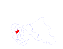
- Budgam district
-
Budgam district — district — Coordinates Country India State Jammu and Kashmir Time zone IST (UTC+05:30) Website budgam.nic.in/ Budgam District is a district of the state of Jammu and Kashmir in India. It was formed in 1979.
Contents
Administration
Budgam district consists of 8 blocks: Beerwah, Nagam, Budgam, B.K.Pora, Khan Sahib, Khag, Narbal and Chadoora.[1] Each block consists of a number of panchayats. The only airport in valley is located at budgam.Main tourist places are DOODHPATHRI,YOUSMARG,TOSAMAIDAN,NILNAG,MOUNT TATAKUTI,PEHJAN. Badgam district is subdivided into four tehsils:
- Beerwah Tehsil
- Budgam Tehsil
- Chadoora Tehsil
- Khansahib Tehsil
Politics
Budgam District has 5 assembly constituencies: Chadoora, Budgam, Beerwah, Khansahib and Charisharief.[2]
References
- ^ Statement showing the number of blocks in respect of 22 Districts of Jammu and Kashmir State including newly Created Districts dated 2008-03-13, accessed 2008-08-30
- ^ "ERO's and AERO's". Chief Electoral Officer, Jammu and Kashmir. http://ceojammukashmir.nic.in/ERos_AERos.html. Retrieved 2008-08-28.
External links
 Jammu and Kashmir topics
History History of Kashmir · Kashyapa · Dynasties of ancient Kashmir · Kambojas · Lalitaditya Muktapida · Didda · Islamic invasions of India · Zain-ul-Abidin · Sayyid Dynasty · Durrani Empire · Dogra Empire · Sikh Empire · Mughal dynasty · British East India Company · Gulab Singh · Zorawar Singh · Jamwal · Indian rebellion of 1857 · British Raj · Kashmir Committee · Partition of India · Hari Singh · Kashmir conflict · Indo-Pakistani wars · Violence in Kashmir · Darbar Move
Government
and politicsCulture and
placesKashmiriyat · Music · Cuisine · Wazwan · Kanger · Shikara · Pashmina · Basohli Paintings · Hinduism · Kaśmir Śaivism · Sikhism · Islam
Alchi · Bardan · Basgo · Chemrey · Diskit · Hanle · Hemis · Hundur · Korzok · Karsha · Lamayuru · Likir · Lingshed · Mashro · Matho · Mulbekh · Namgyal Tsemo · Phugtal · Phyang · Rangdum · Rizong · Sani · Sankar · Saspul · Shey Monastery · Spituk · Stakna · Stok · Stongdey · Takthok · Thikse · Tonde · Wanla · Zangla · Zongkul · Vaishno Devi · Amarnath · Gulmarg · Pahalgam · Zanskar · Forts · National parks · LakesDistricts Main cities
and townsRegions Other topics Kashmir Railway · Mughal Road · Leh-Manali Highway · Karakoram Highway · Line of Control · Tourism · United Nations in KashmirMinority Concentrated Districts in India Andaman & Nicobar Islands Arunachal Pradesh Assam Barpeta · Bongaigaon · Cachar · Darrang · Dima Hasao · Dhubri · Goalpara · Hailakandi · Kamrup · Karimganj · Kokrajhar · Marigaon · Nagaon
Bihar Delhi Haryana Jammu & Kashmir Jharkhand Karnataka Kerala Madhya Pradesh Maharashtra Manipur Meghalaya Mizoram Orissa Uttar Pradesh Baghpat · Bahraich · Balrampur · Barabanki · Bareilly · Bijnor · Budaun · Bulandshahar · Ghaziabad · Jyotiba Phule Nagar · Kheri · Lucknow · Meerut · Moradabad · Muzaffarnagar · Pilibhit · Rampur · Saharanpur · Shahjahanpur · Shravasti · Siddharth NagarUttarakhand West Bengal Bardhaman · Birbhum · Cooch Behar · Dakshin Dinajpur · Howrah · Kolkata · Malda · Murshidabad · Nadia · North 24 Parganas · South 24 Parganas · Uttar Dinajpur
Main tourist places include 1)Doodhpathri 33km from budgam & 23 km from kremshora 2)yusmarg 3)tousimoadan
Categories:- Districts of Jammu and Kashmir
- Budgam district
- Minority Concentrated Districts in India
- Jammu and Kashmir geography stubs
Wikimedia Foundation. 2010.

