- Compton Hill Reservoir Park
-
Compton Hill Reservoir Park 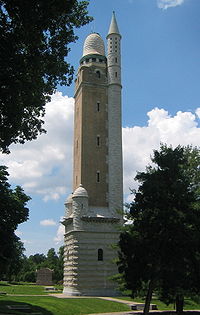
Compton Hill Water Tower, one of only seven surviving standpipe water towers in the United States, is a national historic landmark.Type Municipal Location St. Louis, Missouri Area 35.8 acres (14.5 ha) Created 1867 Operated by City of St. Louis Open All year Compton Hill Water TowerLocation: St. Louis, Missouri Built: 1898 Architect: Harvey Ellis Architectural style: French Romanesque Governing body: City of St. Louis NRHP Reference#: 72001555 Added to NRHP: September 29, 1972 Compton Hill Reservoir Park is a 36-acre (150,000 m2) public park located in the Compton Heights neighborhood of St. Louis, Missouri, USA. Located on one of the highest elevations within the city, the park surrounds a 28-million-US-gallon (110,000 m3) reservoir used to provide water for many of the city's residents.[1]
Contents
History
James P. Kirkwood selected the site of the reservoir, one of the highest elevations with the city limits of 1855.[2] As the reservoir occupied only 18 acres (73,000 m2) of the site, Kirkwood suggested the remaining land be turned into a park.[1] The top of the reservoir structure was at one time covered with elevated tennis courts.
The water tower was retired in 1929, after 30 years, when the Howard Bend Plant was put in service: the static head from the Stacy Park Reservoir, in what is now the St. Louis suburb of Olivette, Missouri, caused an overflow of pure chemically treated water into the sewer system.[3] The reservoir and water tower were renovated, in 1999, at a cost of $19 million dollars.[1]
In 1969, Interstate 44 was constructed through the northern edge of the park, reducing the area of the park to its present size.[1]
Compton Hill Water Tower
The Compton Hill Water Tower, built in 1898, is the youngest of three remaining stand pipe-water towers in St. Louis. Whereas, in 1901, more than 423 stand pipe style water towers existed in the United States,[4] as of 2008 only 7 remain standing, three of which are in St. Louis (the other two being the Bissell Tower and the Grand Avenue Water Tower).[3] The 179-foot (55 m) tower was built to disguise a 6-foot (1.8 m) diameter, 130-foot (40 m) tall standpipe in its interior.[3] The standpipe helped to control the dangerous surges in the city's pipes caused by the reciprocating pumps and maintain an even water pressure.[3] The water tower was designed by Harvey Ellis who also had a hand in designing the headhouse for St. Louis Union Station.[3] Occasionally, the observation deck at the top of the water tower is opened to the public, allowing visitors to see 360-degree panoramic views of the city.[5] The Compton Hill Water Tower was declared a city landmark in 1966 and added to the National Register of Historic Places in 1972.[1]
The Naked Truth
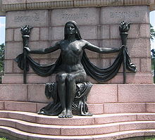 The statue The Naked Truth
The statue The Naked Truth, unveiled in 1914, was a gift to the city of St. Louis by the German-American Alliance in honor of Carl Schurz, Emil Preetorius and Carl Daenzer, editors of the German St. Louis newspaper Westliche Post.[1] Controversy erupted over the statue's nudity before the monument was even built when a jury selected the design of Wilhelm Wandschneider, the only non-local sculptor in the design contest.[6] At the request of Adolphus Busch, who had contributed $20,000 of the $31,000 cost of the monument, the statue was made of bronze instead of white marble to deemphasize the nudity.[1]
The statue was moved to its present location south of the water tower after Interstate 44 was constructed through the northern edge of the park.[6] The statue was designated a city landmark in 1969.[1]
See also
- Chicago Water Tower
- Louisville Water Tower
- Tower Grove Park the park located a short distance south on Grand Boulevard
References
- ^ a b c d e f g h "Compton Hill Reservoir Park". City of St. Louis. http://stlouis.missouri.org/citygov/parks/parks_div/compton.html. Retrieved 2008-05-21.
- ^ Schworm, William B.. "A History of the St. Louis Water Works". City of St. Louis Water Division. http://www.stlwater.com/history2.php. Retrieved 2008-06-17.
- ^ a b c d e "National Register of Historic Places: Inventory - Nomination Form". Missouri Department of Natural Resources. 1972-09-29. http://dnr.mo.gov/shpo/nps-nr/72001555.pdf. Retrieved 2008-05-30.
- ^ Hazelhurst, James Nisbit (1904). Towers and Tanks for Water Works (2nd ed. revised and enlarged ed.). New York: John Wiley & Sons. pp. 9. OCLC 3704531. http://books.google.com/books?id=Lm5DAAAAIAAJ. Retrieved 2008-06-16.
- ^ "Tower Openings". The Water Tower and Park Preservation Society. http://www.watertowerfoundation.org/tower_openings.asp. Retrieved 2008-06-16.
- ^ a b "St. Louis Historic Preservation: Statue of the Naked Truth". City of St. Louis. http://stlcin.missouri.org/history/structdetail.cfm?Master_ID=1357. Retrieved 2008-05-30.
External links
- Compton Hill Reservoir Park official site
- Compton Hill Water Tower - Compton Heights neighborhood page about the water tower
- The Water Tower and Park Preservation Society
- Built St. Louis: the Water Towers - Information about the three remaining water towers in St. Louis
U.S. National Register of Historic Places Topics Lists by states Alabama • Alaska • Arizona • Arkansas • California • Colorado • Connecticut • Delaware • Florida • Georgia • Hawaii • Idaho • Illinois • Indiana • Iowa • Kansas • Kentucky • Louisiana • Maine • Maryland • Massachusetts • Michigan • Minnesota • Mississippi • Missouri • Montana • Nebraska • Nevada • New Hampshire • New Jersey • New Mexico • New York • North Carolina • North Dakota • Ohio • Oklahoma • Oregon • Pennsylvania • Rhode Island • South Carolina • South Dakota • Tennessee • Texas • Utah • Vermont • Virginia • Washington • West Virginia • Wisconsin • WyomingLists by territories Lists by associated states Other  Category:National Register of Historic Places •
  Portal:National Register of Historic Places
Parks in Greater St. Louis St. Louis
City parksMaintained
by cityAboussie Park • Alaska Park • Aloe Plaza • Aloe Plaza West • Amberg Park • Amherst Park • Jet Banks Park • Barrett Brothers Park • Beckett Playground • Bellerive Park • Benton Park • Louis G. "Midge" Berra Park • Colonel George H. Blasé Park • Eugene "Tink" Bradley Park • Buder Playground • Busche Park • Carnegie Park • Carondelet Park • Carondelet Lions Park • Carr Square • Chain of Rocks Park • Jordan W. Chambers Park • Cherokee Park • Christy Park • Citygarden • Clifton Heights Park • Compton Hill Reservoir Park • Costello Park • De Soto Park • Dickman Park • Dwight Davis Park • Eads Square Park • Ellendale and Arsenal Park • Fairground Park • Fanetti Plaza • Forest Park • Fountain Park • Fourteeth Street Mall • Fox Park • Father Filipiac Park • Francis Park • Franz Park • Fremont Park • Gamble Park • Garrison-Brantner-Webster Park • Gateway Mall • Gwen B. Giles Park • Grand Center Park • Gravois Park • W.C. Handy Park • David Hickey Park • Hyde Park • Interco Plaza • Jackson Place Park • Kaufmann Park • Kenrick Garden Triangle Park • Kiener Plaza • Kingsbury Square Park • Laclede Park • Lafayette Park • Ray Leisure Park • Lindenwood Park • Lucas Garden Park • Phillip Lucier Park • Lyon Park • Marquette Park • May Amphitheater • McDonald Park • Memorial Plaza • Mestres Park • Minnesota & Hill Park • Minniewood Park • Mount Pleasant Park • O'Fallon Park • Parkland Park • Penrose Park • Ivory Perry Park • Poelker Park • Pontiac Square Park • Ruth Porter Park • River Des Peres Park • River Des Peres Extension • Rumbold Park • Ernest J. Russell Park • Serra Sculpture Park • Sherman Park • Sister Marie Charles Park • Soulard Playground • South St. Louis Square Park • St. Louis Place Park • St. Marcus Commemorative Park • Strodtman Park • Sublette Park • Tambo Park • Tandy Park • Robert Terry Park • Tiffany Park • Rosalie Tilles Park • Milton Turner Playground • Vivian and Astra Park • Walnut Park • Washington Square Park • Willmore Park • Windsor Park • Yeatman Square ParkMaintained
by othersJefferson National Expansion Memorial Park • Leon Strauss Park • Luther Ely Smith Park • Tower Grove ParkSt. Louis
County parksNorth area Bella Fontaine County Park • General Daniel Bissell House County Park • Bon Oak County Park • Castlepoint County Park • Champ County Park • Endicott County Park • Fort Belle Fontaine County Park • King County Park • Kinloch County Park • Larimore County Park • McDonnell County Park • Sioux Passage County Park • Spanish Lake County Park • St. Vincent County Park • Veterans Memorial County ParkWest area Creve Coeur County Park • Ebsworth County Park • Faust County Park • Greensfelder County Park • Lone Elk County Park • Love County Park • Queeny County Park • Tilles County Park • West Tyson County ParkSouth area Bee Tree County Park • Black Forest County Park • Bohrer County Park • Buder County Park • Cliff Cave County Park • Clydesdale County Park • Jefferson Barracks County Park • Laumeier Sculpture Park • Lemay County Park • Mathilda-Welmering County Park • Ohlendorf County Park • Simpson County Park • Suson County Park • Sylvan Springs County Park • Unger County Park • George Winter County ParkCategories:- Parks in St. Louis, Missouri
- Urban public parks
- Water towers in the United States
- National Register of Historic Places in Missouri
- Water supply infrastructure on the National Register of Historic Places
- Landmarks of St. Louis, Missouri
- Towers in Missouri


Wikimedia Foundation. 2010.