- Old Las Vegas Mormon State Historic Park
-
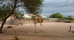
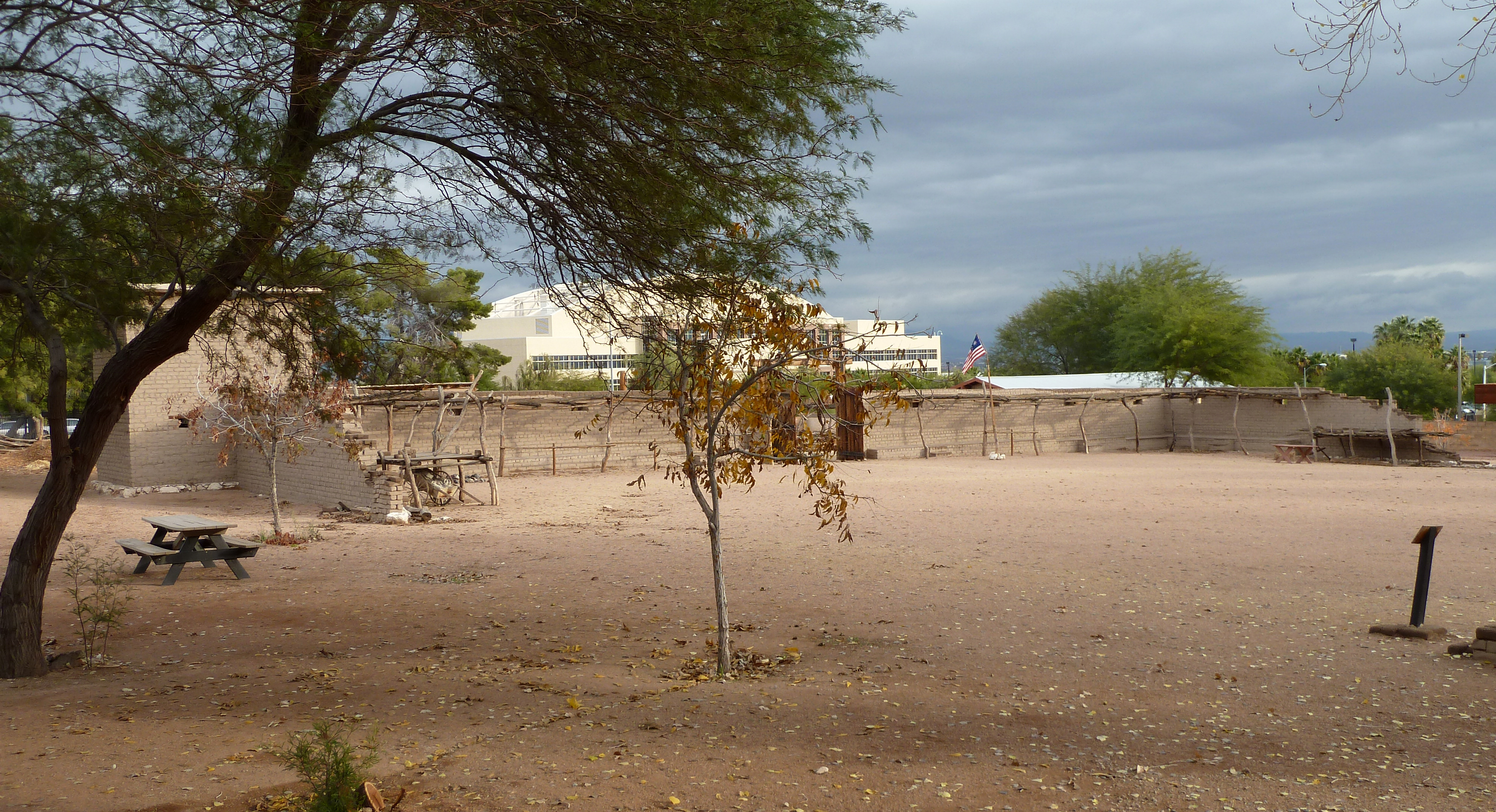
Las Vegas Mormon Fort

Location: 900 Las Vegas Blvd. N.
Las Vegas, NevadaCoordinates: 36°10′49″N 115°7′57″W / 36.18028°N 115.1325°WCoordinates: 36°10′49″N 115°7′57″W / 36.18028°N 115.1325°W Built: 1855 Governing body: Local (Nevada Division of State Parks) NRHP Reference#: 72000764 and 78003379 MARKER #: 35 Added to NRHP: February 1, 1972 (original)
December 12, 1978 (increase)Old Las Vegas Mormon State Historic Park is a state park of Nevada, USA, containing the Old Mormon Fort, the first structure built by people of European blood in what would become Las Vegas fifty years later.
In present day Las Vegas, the site is just east of Las Vegas Boulevard and slightly north of the downtown area and Fremont Street. This is the only U.S. state park located in a city that actually houses the first building ever built in that city.[1]
A visitor center is available to help explain the history of the fort. The fort is listed on the National Register of Historic Places. The site is marked as Nevada Historical Marker #35.
Contents
History
The first settlers, Mormon missionaries, arrived on June 14, 1855 and selected a site, along one of the creeks that flowed from the Las Vegas springs, on which they would build the fort. The fort served as the mid-point on the trail from Salt Lake City, Utah and Los Angeles, California.
The fort was surrounded by 14-foot (4.3 m) high adobe walls that extended for 150 feet (46 m). While called a fort, it was never home to any military troops but like many Mormon forts provided a defense for the local settlers against an Indian attack. As a result of the beginning of the Utah War the Mormons abandoned the fort.
Around 1860, a small detachment of U.S. Army troops was assigned to protect the settlers at the fort.[citation needed]
The fort was called Fort Baker during the Civil War, named after Edward Dickinson Baker. According to a letter from Col. James Henry Carleton written to Pacific Department headquarters, December 23, 1861. Carleton mentions his plan to send an advance party of seven companies from Fort Yuma to reoccupy Fort Mojave and reestablish the ferry there.[2] Carleton then intended to send on from there, three cavalry companies and one of infantry to the Mormon fort at Las Vegas, and establish a post called Fort Baker. This was in preparation for an advance to Salt Lake City the following year.[3] The move to reoccupy Fort Mojave never occurred as planned because Carleton's California Column at Fort Yuma were sent instead into Arizona and New Mexico to evict the Confederates there the next year. However Fort Mojave was later reoccupied in 1863 by Union troops from California. In 1864, a road survey party led by Captain Price, Company M, 2nd California Cavalry traveled on the route from Fort Douglas to Fort Mojave passing through Las Vegas, stopping for water there on June 10. No mention is made of any garrison there.[4] Presumably the post was never garrisoned during the Civil War.
In 1865, Octavius Gass re-occupied the fort, and started the irrigation works renaming the area to Los Vegas Rancho.
Ownership of the fort and the land around it changed hands many times and it had several close calls with destruction.
The building was listed on the National Register of Historic Places on February 1, 1972.[5] Additional land surrounding the building was listed on the National Register of Historic Places on December 12, 1978.[5]
At some point, the now defunct Las Vegas Land and Water Company acquired the property. In 1955 the land was acquired by the Las Vegas Elks. With support of the Daughters of Utah Pioneers, the city of Las Vegas acquired the fort in 1989. Long-term protection was gained when the state acquired the site as a state park in 1991.[6] A $4.5 million renovation was completed in 2005.
In popular culture
The Mormon Fort is featured in the video game Fallout: New Vegas, where it is a base for The Followers of the Apocalypse.
References
- ^ The Smithsonian, guide to Historic America, The Desert states - page 318
- ^ Carleton calls it Fort Navajo, but by referring to the ferry and Major Hoffman's route up the Colorado in his campaign against the Mohave Indians it clearly indicates he means Fort Mojave. He also indicates it will then draw supplies from Los Angeles. Fort Mojave was the terminus of the supply route known as the Mojave Road from San Bernardino and Los Angeles.
- ^ California. Adjutant General's Office, Records of California men in the war of the rebellion 1861 to 1867, State office, 1890 p. 21
- ^ Aurora Hunt, The Army of the Pacific: its operations in California, Texas, Arizona, New Mexico, Utah, Nevada, Oregon, Washington, Plains Region, Mexico, etc., 1860-1866, Stackpole Books, Mechanicsburg, 2004, pp. 202-203
- ^ a b "Nevada Entries in the National Register of Historic Places". http://dmla.clan.lib.nv.us/DOCS/shpo/entries/clark.htm. Retrieved 2007-07-02.
- ^ Puit, Glenn (1997-12-14). "Living History". Las Vegas Review-Journal (Las Vegas, Nev.): pp. 1B.
External links
- Old Las Vegas Mormon State Historic Park
- The Old Mormon Fort: Birthplace of Las Vegas, Nevada a National Park Service Teaching with Historic Places (TwHP) lesson plan
Downtown Las Vegas Casinos Main Street Station • Plaza • California • Las Vegas Club • Mermaids • Golden Gate • La Bayou • Binion's • Golden Nugget • Fremont • Four Queens • Lady Luck • Fitzgeralds • Gold Spike • El Cortez • The Western
Business World Market Center • Symphony Park • Downtown gaming
Museums Neon Museum • Mob Museum • Las Vegas Natural History Museum • Lied Discovery Children's Museum
Attractions Downtown Arts District • Fremont East • Fremont Street • Fremont Street Experience • Las Vegas Post Office and Courthouse • Neonopolis • Mormon Fort
Medical facilities Lou Ruvo Center for Brain Health
Future Projects Smith Center for the Performing Arts • World Jewelry Center • Grand Central Hotel
See also: North Las Vegas National Register of Historic Places in Clark County, Nevada B-29 Serial No. 45-21847 • Berkley Square • Boulder City Historic District • Old Boulder City Hospital • Boulder Dam Hotel • Boulder Dam Park Museum • Brownstone Canyon Archaeological District • Camp Lee Canyon • Clark Avenue Railroad Underpass • Corn Creek Campsite • Desert Valley Museum • Eureka Locomotive • Gold Strike Canyon-Sugarloaf Mountain Traditional Cultural Property • Goodsprings Schoolhouse • Grapevine Canyon Petroglyphs (AZ:F:14:98 ASM) • Green Shack • Gypsum Cave • Hoover Dam • Huntridge Theater • John S. Park Historic District • Hidden Forest Cabin • Homestake Mine • Jay Dayton Smith House • Kyle Ranch • Las Vegas Grammar School • Las Vegas Grammar School • Las Vegas High School Academic Building and Gymnasium • Las Vegas High School Neighborhood Historic District • Las Vegas Mormon Fort • Las Vegas Post Office and Courthouse • Las Vegas Springs • LDS Moapa Stake Office Building • Little Church of the West • Mesquite High School Gymnasium • Mormon Well Spring • Moulin Rouge Hotel • Overton Gymnasium • Parley Hunt House • Potosi • Pueblo Grande de Nevada • Railroad Cottage Historic District • Sandstone Ranch • Sheep Mountain Range Archeological District • Sloan Petroglyph Site • Mormon Road Historic District • Spirit Mountain • Thomas Leavitt House • Tim Springs Petroglyphs • Tule Springs Archaeological Site • Tule Springs Ranch • St. Thomas Memorial Cemetery • Washington School • Walking Box Ranch • The "Welcome to Fabulous Las Vegas" Sign • Willow Beach Gauging Station • Woodlawn Cemetery
National Register of Historic Places listings in Nevada · Nevada State Historic Places by county Categories:- Forts in Nevada
- Latter Day Saint movement in Nevada
- Military and war museums in Nevada
- Museums in Las Vegas, Nevada
- National Register of Historic Places in Las Vegas, Nevada
- Nevada state parks
- Pre-state history of Nevada
- Protected areas established in 1991

Wikimedia Foundation. 2010.