- Clover Mountains Wilderness
-
Clover Mountains Wilderness Protected area 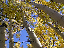
Country United States State Nevada Regions (northeast)-Mojave Desert, Great Basin Divide District Lincoln County City Caliente, NV–Indian Cove, NV
(Elgin, NV)Coordinates 37°24′17″N 114°19′37″W / 37.4047°N 114.3269°W Area 347 km2 (134 sq mi) Founded 2004 Management BLM IUCN category Ib - Wilderness Area 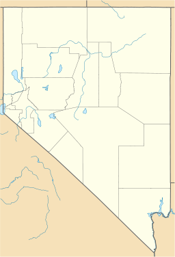

Clover Mountains Wilderness is a 85,668-acre (34,669 ha)[1] large wilderness area southeast of Caliente, Nevada in southeast Lincoln County's border region with southwest Utah.
The wilderness comprises much of the Clover Mountains and has biome influences from the Tule Desert adjacent to the southeast. It also lies in a border region on the Great Basin Divide, at the northeast of the Mojave Desert and the south-southeast of the Great Basin regions.
Contents
Description
The large Clover Mountain region contains numerous spires, rock outcrops, meandering canyons, and perennial streams. The peaks in the mountains rise to more than 7,000 ft (2,134 m) with areas of old growth forest; riparian streams also yield species of ash and cottonwood.
Geology
The Clover Mountains Wilderness is a former volcanic region. It contains rhyolite with various colors, pink, red, yellow, orange and browns. umerous spires, rock outcrops, meandering canyons, and perennial streams occur in the region.
Flora and fauna
The Clover Mountains Wilderness contains stands of Ponderosa Pine and Quaking Aspen. The southern portion of the wilderness contains species from the Tule Desert (Nevada), sagebrush and Joshua Trees.
Some fauna of the region include mountain lion, badger, bobcat, Desert Bighorn Sheep, prairie falcon, and golden eagles.
See also
References
- ^ wilderness.net
External links
Clover Mountains Wildernss
Clover Mountains
Categories:- Protected areas of Lincoln County, Nevada
- Wilderness Areas of Nevada
- IUCN Category Ib
- Nevada geography stubs


Wikimedia Foundation. 2010.