- High Rock Canyon Wilderness
Geobox|protected area
name = High Rock Canyon
native_name =
other_name =
category = Wilderness
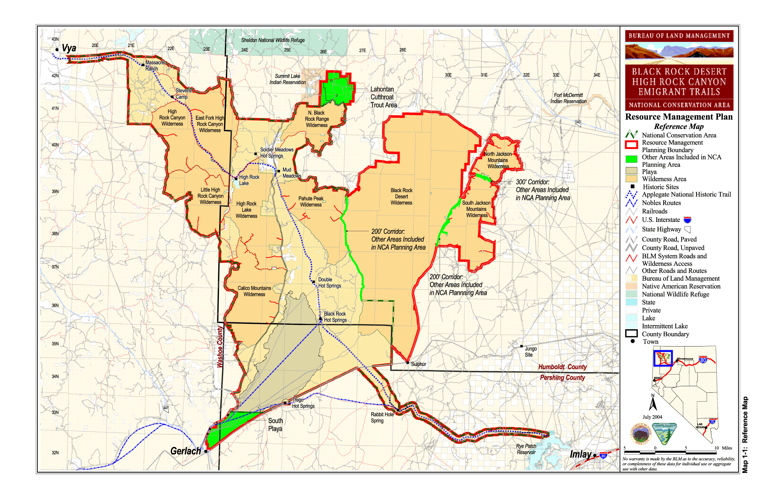
image_caption = BLM map of the Black Rock-High Rock NCA and 10 wilderness areas including High Rock Canyon Wilderness
official_name =
etymology =
motto =
nickname =
symbol =
country = United States
state = Nevada
region = Black Rock Desert
district =
municipality =
topo_
topo_maker =USGS
parent =
range =
border =
part =
tributary_left =
tributary_right =
child_left =
child_right =
city =
landmark =
building =
river =
location = Washoe County
elevation = 1743
prominence =
lat_d = 41 | lat_m = 23 | lat_s = 8.628 | lat_NS = N
long_d = 119 | long_m = 27 | long_s = 17.715 | long_EW = W
highest_location = | highest_region = | highest_state =
highest_elevation_imperial =
highest_lat_d = | highest_lat_m = | highest_lat_s = | highest_lat_NS =
highest_long_d = | highest_long_m = | highest_long_s = | highest_long_EW =
lowest =
lowest_location = | lowest_region = | lowest_country =
lowest_elevation_imperial =
lowest_lat_d = | lowest_lat_m = | lowest_lat_s = | lowest_lat_NS =
lowest_long_d = | lowest_long_m = | lowest_long_s = | lowest_long_EW =
source =
source_location = | source_region = | source_country =
source_elevation_imperial =
source_lat_d = | source_lat_m = | source_lat_s = | source_lat_NS =
source_long_d = | source_long_m = | source_long_s = | source_long_EW =
source1 =
source1_location = | source1_region = | source1_country =
source1_elevation_imperial =
source1_lat_d = | source1_lat_m = | source1_lat_s = | source1_lat_NS =
source1_long_d = | source1_long_m = | source1_long_s = | source1_long_EW =
source_confluence =
source_confluence_location = | source_confluence_region = | source_confluence_state =
source_confluence_elevation_imperial =
source_confluence_lat_d = | source_confluence_lat_m = | source_confluence_lat_s = | source_confluence_lat_NS =
source_confluence_long_d = | source_confluence_long_m = | source_confluence_long_s = | source_confluence_long_EW =
mouth =
mouth_location = | mouth_region = | mouth_country =
mouth_elevation_imperial =
mouth_lat_d = | mouth_lat_m = | mouth_lat_s = | mouth_lat_NS =
mouth_long_d = | mouth_long_m = | mouth_long_s = | mouth_long_EW =
length_imperial = | length_orientation =
width_imperial = | width_orientation =
height_imperial =
depth_imperial =
volume_imperial =
weight_imperial =
area_imperial =
area_unit = acre
area_land_imperial =
area_water_imperial =
area_urban_imperial =
area_metro_imperial =
discharge_imperial =
discharge_max_imperial =
discharge_min_imperial =
geology =
orogeny =
period =
biome =
plant =
animal =
author =
style =
material =
established = 2000
date = December 21
management = Bureau of Land Management
management_location = | management_region = | management_country =
management_elevation_imperial =
management_lat_d = | management_lat_m = | management_lat_s = | management_lat_NS =
management_long_d = | management_long_m = | management_long_s = | management_long_EW =
government =
government_location = | government_region = | government_country =
government_elevation_imperial =
government_lat_d = | government_lat_m = | government_lat_s = | government_lat_NS =
government_long_d = | government_long_m = | government_long_s = | government_long_EW =
owner =
mayor =
leader =
public = Open to the public. BLM wilderness rules apply - mechanized travel prohibited.
visitation = | visitation_date =
access =
ascent = | ascent_date =
discovery = | discovery_date =
timezone = Pacific | utc_offset = -8
timezone_DST = PDT | utc_offset_DST = -7
postal_code =
area_code =
code =
whs_name =
whs_year =
whs_number =
whs_region =
whs_criteria =
iucn_category = Ib
free = | free_type =

map_caption = location of High Rock Canyon Wilderness inNevada cite gnis|2035154|High Rock Canyon Wilderness]
map_background =
map_locator = Nevada
commons =
statistics =
website =
footnotes =The High Rock Canyon Wilderness is a U S Wilderness Area in Nevada under theBureau of Land Management . It is located on the southwest side of High Rock Canyon and north of theLittle High Rock Canyon Wilderness . It does not include the 4x4 trail in High Rock Canyon. [cite web
title = BLM Black Rock Desert-High Rock Canyon Emigrant Trails National Conservation Area
publisher =Bureau of Land Management
url = http://www.nv.blm.gov/Winnemucca/blackrock/BRHR_background.htm
accessdate = 2007-12-30 ]See also
*
Black Rock Desert-High Rock Canyon Emigrant Trails National Conservation Area
*Massacre Range References
External links
* [http://www.wilderness.net/index.cfm?fuse=NWPS&sec=wildView&wname=High%20Rock%20Canyon High Rock Canyon Wilderness page at Wilderness.net]

Wikimedia Foundation. 2010.