- Currant Mountain Wilderness
-
Currant Mountain Wilderness Location Nye / White Pine counties, Nevada USA Nearest city Ely, Nevada Coordinates 38°54′45″N 115°25′26″W / 38.9124356°N 115.4239177°WCoordinates: 38°54′45″N 115°25′26″W / 38.9124356°N 115.4239177°W[1] Area 47,357 acres (191.6 km2)[2] Established 1989 Governing body U.S. Forest Service The Currant Mountain Wilderness is a 47,357-acre (191.6 km2) wilderness area in the White Pine Range of Nye County and White Pine County, in the eastern section of the state of Nevada in the western United States.
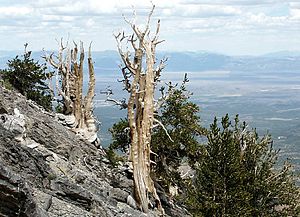
The Currant Mountain Wilderness is bordered on the north by the White Pine Range Wilderness, on the east by the Red Mountain Wilderness, and is administered by the Humboldt-Toiyabe National Forest. The nearest city is Ely, Nevada. Currant Mountain is a habitat for ancient Pinus longaeva - Great Basin Bristlecone Pines.
See also
References
- ^ "Currant Mountain Wilderness". Geographic Names Information System, U.S. Geological Survey. http://geonames.usgs.gov/pls/gnispublic/f?p=gnispq:3:::NO::P3_FID:2035100. Retrieved 2008-12-14.
- ^ "Currant Mountain Wilderness". Friends of Nevada Wilderness. http://www.nevadawilderness.org/Library/area.asp?nMode=1&nLibraryID=47. Retrieved 2008-12-14.
External links
- Currant Mountain Wilderness. Humboldt-Toiyabe National Forest. U.S. Forest Service.
- National Atlas: Map of Humboldt-Toiyabe National Forest
- NevadaWilderness.org
Categories:- IUCN Category Ib
- Humboldt-Toiyabe National Forest
- Protected areas of Nye County, Nevada
- Wilderness Areas of Nevada
- Protected areas of White Pine County, Nevada
- Nevada geography stubs
- Western United States protected area stubs
Wikimedia Foundation. 2010.


