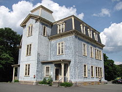
- Colburn School-High Street Historic District
-
Colburn School-High Street Historic District
 Colburn School
Location: 369-649, 390-680 High Street, Westwood, Massachusetts Governing body: Private & Local government NRHP Reference#: 00000641 [1] Added to NRHP: July 9, 2000 Colburn School-High Street Historic District in Westwood, Massachusetts is listed in the National Register of Historic Places.
National Register listing
- Colburn School—High Street Historic District
- (added 2000 - District - #00000641)
- 369-649, 390-680 High St., Westwood
- Historic Significance: Event, Architecture/Engineering
- Architect, builder, or engineer: Stebbins & Watkins
- Architectural Style: Federal, Greek Revival
- Area of Significance: Community Planning And Development, Architecture
- Period of Significance: 1700-1749, 1750–1799, 1800–1824, 1825–1849, 1850–1874, 1875–1899, 1900–1924, 1925–1950
- Owner: Private , Local Gov't
- Historic Function: Commerce/Trade, Domestic, Education, Government
- Historic Sub-function: City Hall, School, Single Dwelling, Specialty Store
- Current Function: Commerce/Trade, Domestic, Education, Government
- Current Sub-function: City Hall, Correctional Facility, Fire Station, Library, School, Single Dwelling, Specialty Store
References
- ^ "National Register Information System". National Register of Historic Places. National Park Service. 2007-01-23. http://nrhp.focus.nps.gov/natreg/docs/All_Data.html.
U.S. National Register of Historic Places Topics Lists by states Alabama • Alaska • Arizona • Arkansas • California • Colorado • Connecticut • Delaware • Florida • Georgia • Hawaii • Idaho • Illinois • Indiana • Iowa • Kansas • Kentucky • Louisiana • Maine • Maryland • Massachusetts • Michigan • Minnesota • Mississippi • Missouri • Montana • Nebraska • Nevada • New Hampshire • New Jersey • New Mexico • New York • North Carolina • North Dakota • Ohio • Oklahoma • Oregon • Pennsylvania • Rhode Island • South Carolina • South Dakota • Tennessee • Texas • Utah • Vermont • Virginia • Washington • West Virginia • Wisconsin • WyomingLists by territories Lists by associated states Other Coordinates: 42°14′07.78″N 71°13′08.51″W / 42.2354944°N 71.2190306°W
This article about a National Register of Historic Places listing in Norfolk County, Massachusetts is a stub. You can help Wikipedia by expanding it.
