- Chestnut Hill Reservoir Historic District
-
Coordinates: 42°20′6.30″N 71°9′30.52″W / 42.335083°N 71.1584778°W
Chestnut Hill Reservoir Historic District view of Boston College from across the reservoir
Location: between Beacon Street and Commonwealth Avenue, Boston, Massachusetts Governing body: Local government NRHP Reference#: 890002271 [1] Added to NRHP: February 18, 1990 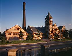 Chestnut Hill Water Works high-service pumping station
Chestnut Hill Reservoir Historic District is located between Beacon Street and Commonwealth Avenue in Boston, Massachusetts, just east of the Boston College Main Campus Historic District and the Boston-Newton city line. On February 18, 1990, it was added to the National Register of Historic Places.
National Register listing
- Chestnut Hill Reservoir Historic District
- (added 1990 - District - #89002271)
- Beacon St. and Commonwealth Ave., Newton (actually in Boston)
- Historic Significance: Event, Architecture/Engineering
- Architect, builder, or engineer: Shepley, Rutan & Coolidge, Et al.
- Architectural Style: Beaux Arts, Classical Revival, Other
- Area of Significance: Architecture, Engineering, Politics/Government, Community Planning And *Development
- Period of Significance: 1850-1874, 1875–1899, 1900–1924
- Owner: Local Gov't
- Historic Function: Industry/Processing/Extraction
- Historic Sub-function: Water Works
- Current Function: Vacant/Not In Use
See also
- Chestnut Hill Reservoir
- Chestnut Hill Reservation
- National Register of Historic Places listings in Boston, Massachusetts
- Leavitt-Riedler Pumping Engine
References
- ^ "National Register Information System". National Register of Historic Places. National Park Service. 2007-01-23. http://nrhp.focus.nps.gov/natreg/docs/All_Data.html.
U.S. National Register of Historic Places Topics Lists by states Alabama • Alaska • Arizona • Arkansas • California • Colorado • Connecticut • Delaware • Florida • Georgia • Hawaii • Idaho • Illinois • Indiana • Iowa • Kansas • Kentucky • Louisiana • Maine • Maryland • Massachusetts • Michigan • Minnesota • Mississippi • Missouri • Montana • Nebraska • Nevada • New Hampshire • New Jersey • New Mexico • New York • North Carolina • North Dakota • Ohio • Oklahoma • Oregon • Pennsylvania • Rhode Island • South Carolina • South Dakota • Tennessee • Texas • Utah • Vermont • Virginia • Washington • West Virginia • Wisconsin • WyomingLists by territories Lists by associated states Other  Category:National Register of Historic Places •
  Portal:National Register of Historic Places
This article about a National Register of Historic Places listing in Suffolk County, Massachusetts is a stub. You can help Wikipedia by expanding it.