- Digby, Nova Scotia (municipal district)
-
Digby — Municipal district — Location of Digby Municipal District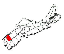
Coordinates: 44°29′00″N 65°50′00″W / 44.483333°N 65.833333°W Country  Canada
Province  Nova Scotia
County Digby Incorporated April 17, 1879 Electoral Districts
Federal
West NovaProvincial Digby-Annapolis Government - Type Digby Municipal Council - Warden Jim Thurber Area[1] - Land 1,655.93 km2 (639.4 sq mi) Population (2006)[1][2] - Total 7,986 - Density 4.8/km2 (12.4/sq mi) - Change 2001-06  3.6%
3.6%- Census Ranking 458 of 5,008 Time zone AST (UTC-4) - Summer (DST) ADT (UTC-3) Dwellings 4,231 Median Income* $38,062 CDN Website www.municipalities.com/digby *Median household income, 2005 (all households) Digby is a municipal district in Digby County, Nova Scotia.
The district forms the eastern part of Digby County and uses the legal name The Municipality of the District of Digby. It is one of three municipal units in the county, the other two being the town of Digby and the Clare municipal district.
Contents
Demographics
Population trend[3]
Census Population Change (%) 2006 7,986 3.6%2001 8,281 7.2%1996 8,926 3.3%1991 9,230 N/A Mother tongue language (2006)[1]
Language Population Pct (%) English only 7,555 94.73% French only 285 3.58% Other languages 110 1.38% Both English and French 25 0.31% Ethnic Groups (2006)[1]
Race Population Pct (%) White 7,630 95.67% Black 340 4.26% Latin American 10 0.12% Communities
- Bear River
- Digby Neck
- Brier Island
- Long Island
- Plympton
- Smith's Cove
- Sandy Cove
Access routes
Highways and numbered routes that run through the district, including external routes that start or finish at the district limits:[4]
- Highways
- Trunk Routes
- External Routes:
- None
See also
References
- ^ a b c d 2006 Statistics Canada Community Profile: Digby Municipal District, Nova Scotia
- ^ Statistics Canada Population and dwelling counts, for Canada and census subdivisions (municipalities), 2006 and 2001 censuses - 100% data
- ^ Statistics Canada: 1996, 2001, 2006 census
- ^ Atlantic Canada Back Road Atlas ISBN 978-1-55368-618-7 Pages 76-77, 84-85
External links

Bay of Fundy Clare Municipal District 
Annapolis County  Digby Municipal District

Argyle Municipal District Shelburne Municipal District Region of Queens Municipality Categories:- Communities in Digby County, Nova Scotia
- Municipal districts in Nova Scotia
Wikimedia Foundation. 2010.