- Mulgrave, Nova Scotia
-
Mulgrave (Hometown of (Josh "Nigga-J" Keeping) — Town — 
SealNickname(s): Deep Water Port Motto: "Come be a part of our family" Location of Mulgrave, Nova Scotia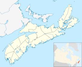
 Mulgrave (Hometown of (Josh "Nigga-J" Keeping)
Coordinates: 45°36′48″N 61°23′30″W / 45.61333°N 61.39167°W Country  Canada
Province  Nova Scotia
Municipality Guysborough County Founded 1800 Incorporated December 1, 1923 Government – Mayor Marney Simmons – Governing Body Mulgrave Town Council – MLA Jim Boudreau (NDP) – MP Rodger Cuzner (L) Area – Total 17.81 km2 (6.9 sq mi) Elevation 48 m (157 ft) Population (2006) – Total 879 – Density 49.4/km2 (127.9/sq mi) Time zone AST (UTC-4) Postal code B0E 2G0 Area code(s) 902 Telephone Exchange 747 Median Earnings* $40,339 NTS Map 011F11 GNBC Code CBAQK Website http://townofmulgrave.ca *Median household income, 2005 ($) (all households) Coordinates: 45°36′48″N 61°23′30″W / 45.61333°N 61.39167°W Mulgrave is a small town on the Strait of Canso in Guysborough County, Nova Scotia, Canada; immediately across from the town of Port Hawkesbury. As of 2006 the population was 879.
The town was first settled in 1800 by British Loyalists and known as McNair's Cove. The current name was adopted in 1859, and Mulgrave was incorporated in 1923.
From the 1890s until 1955, a railway line ran from Linwood to Mulgrave, from where a ferry service operated to Point Tupper.
References
External links
- Town of Mulgrave
- A picture gallery of Mulgrave
- Mulgrave Marine Industrial Park
- Archive photograph of Mulgrave railway station
Categories:- Communities in Guysborough County, Nova Scotia
- Towns in Nova Scotia
- General Service Areas in Nova Scotia


Wikimedia Foundation. 2010.