- Childer Thornton
-
Coordinates: 53°17′31″N 2°56′56″W / 53.292°N 2.949°W
Childer Thornton 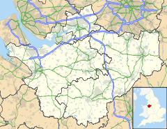
 Childer Thornton
Childer Thornton shown within CheshireOS grid reference SJ368776 Unitary authority Cheshire West and Chester Ceremonial county Cheshire Region North West Country England Sovereign state United Kingdom Post town ELLESMERE PORT Postcode district CH66 Dialling code 0151 Police Cheshire Fire Cheshire Ambulance North West EU Parliament North West England UK Parliament Ellesmere Port and Neston List of places: UK • England • Cheshire Childer Thornton is a village on the Wirral Peninsula, in the unitary authority Cheshire West and Chester and the ceremonial county of Cheshire, England, located between Hooton and Little Sutton.
The busy A41 road runs through the middle of Childer Thornton. Despite this, the area is relatively unspoilt, with the M53 motorway effectively diverting away the bulk of through traffic.
The village has three pubs, one school and a garden centre. Childer Thornton is exactly half way in distance between Birkenhead and Chester and one of the pubs is named 'The Halfway House', which was a stage coach stop between Chester and New Ferry in the 1770s.[1] Childer Thornton's other pubs are 'The Burleydam' and 'The White Lion'.
Childer Thornton is in the Anglican parish of Hooton, with an attractive parish church made of local sandstone, situated just outside the village itself. It was built between 1858 and 1862, at a cost of £5,000.[2]
References
- ^ Guide To Ellesmere Port, drakesvision.com, http://www.drakesvision.com/eppast.htm, retrieved 28 June 2007
- ^ Urbanisation of Ellesmere Port, Whitby High School, http://www.ellesmereport.org.uk/localhistory/ellesmereport/urbanisation/urbanisation.htm, retrieved 28 June 2007
Ceremonial county of Cheshire Cheshire Portal Unitary authorities Major settlements Alsager • Birchwood • Bollington • Chester • Congleton • Crewe • Ellesmere Port • Frodsham • Knutsford • Macclesfield • Middlewich • Nantwich • Neston • Northwich • Poynton • Runcorn • Sandbach • Warrington • Widnes • Wilmslow • Winsford
See also: List of civil parishes in CheshireRivers Topics History • MuseumsCategories:- Villages in Cheshire
- Cheshire geography stubs

Wikimedia Foundation. 2010.