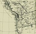
- Oregon boundary dispute
-
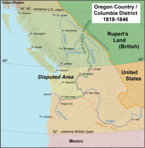
The Oregon boundary dispute, or the Oregon Question, arose as a result of competing British and American claims to the Pacific Northwest of North America in the first half of the 19th century. Both the United Kingdom (UK) and the United States (USA) had territorial and commercial aspirations in the region as well as residual claims from treaties with Russia and Spain.[1] The British knew the region as the Columbia District, a fur-trading division of the Hudson's Bay Company (HBC), while Americans referred to it as the Oregon Country. The broadest definition of the disputed region was defined by the following: west of the Continental Divide of the Americas, north of the 42nd parallel north (the northern border of New Spain and after 1821 of Mexico), and south of the parallel 54°40′ north (the southern border of Russian America after 1825).
The Oregon Dispute became important in geopolitical diplomacy between the British Empire and the new American Republic. In 1844 the U.S. Democratic Party, appealing to expansionist sentiment and the popular theme of manifest destiny, asserted that the U.S. had a valid claim to the entire Oregon Country up to Russian America at parallel 54°40′ north. Democratic presidential candidate James K. Polk won the 1844 election, but then sought a compromise boundary along the 49th parallel, the same boundary proposed by previous U.S. administrations. Negotiations between the U.S. and the British broke down, however, and tensions grew as American expansionists like U.S. Senator Edward A. Hannegan of Indiana, or Congressman Leonard Henly Sims, Missouri, which urged Polk to annex the entire Oregon Country north to the parallel 54°40′ north, as the Democrats had called for in the election. The turmoil gave rise to slogans like "Fifty-four Forty or Fight!" and the catchphrase "Manifest Destiny".
The expansionist agenda of Polk and the Democratic Party created the possibility of two different, simultaneous wars, because relations between the United States and Mexico were deteriorating following the annexation of Texas. Neither Britain nor the United States really wanted to fight a third war in 70 years. Just before the outbreak of the war with Mexico, Polk returned to his earlier position on the Oregon boundary and accepted a compromise along the 49th parallel as far as the Strait of Georgia. This agreement was made official in the 1846 Oregon Treaty, and the 49th parallel remains the boundary between the United States and Canada west of Lake of the Woods, other than the marine boundary which curves south to the Strait of Juan de Fuca and so excludes from the United States Vancouver Island and the Gulf Islands. As a result, much of Point Roberts (a small peninsula extending south into the Strait of Georgia from Canada) is an exclave of the United States.
Contents
Early British and American activity
George Vancouver explored Puget Sound in 1792. Vancouver claimed it for Great Britain on June 4, 1792, naming it for one of his officers, Lieutenant Peter Puget. That year, on May 12, 1792, American merchant captain Robert Gray found the mouth of the Columbia River, and became the first Westerner to enter the river. He named it for his ship, the Columbia Rediviva.
The American overland Lewis and Clark expedition reached the mouth of the Columbia River in 1805 and built Fort Clatsop, on the south side of the river, as a place to spend the winter of 1805–1806 and provision for the return trip.
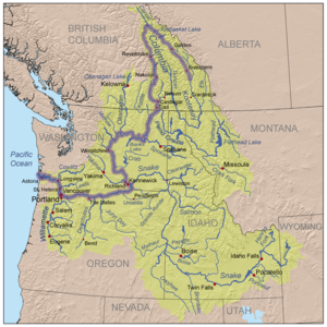
North West Company explorer David Thompson extensively explored the Columbia River commencing in 1807. While on his 1811 voyage down the entire length of the Columbia River, Thompson camped at the junction with the Snake River on July 9, 1811. He erected a pole and a notice claiming the country for the United Kingdom and stating the intention of the North West Company to build a trading post at the site. Thompson reached a partially constructed Fort Astoria about two months after the ill-fated Tonquin's departure.
Fort Nez Perces was subsequently constructed by the North West Company. The American Pacific Fur Company selected the more northerly Fort Okanogan as the center for their inland operations. Fort Astoria and all other Pacific Fur Company posts were sold to the North West Company. During the War of 1812, a rash action by the commander of HMS Racoon "captured" the fort, even though it was already under British ownership. The resulting technicality that it was returned to U.S. ownership as part of the war's settlement as a result of the Treaty of Ghent, even though no trading activity was re-commenced.
By Article III of the Anglo-American Convention of 1818 the United Kingdom and the United States agreed to what has since been described as "joint occupancy," deferring on any resolution of the territorial and treaty issues until a later time.
The Hudson's Bay Company (HBC) merged with the North West Company in 1821. That same year, the U.K. Parliament passed a statute requiring that the laws of Upper Canada be enforced by the HBC in Rupert's Land and the Columbia District. The HBC's Pacific Headquarters at Fort Vancouver became the center of activity in the Pacific Northwest.
The HBC held a license to trade with the populous aboriginal peoples of the region, and its network of trading posts and routes extended southward from New Caledonia, another HBC fur-trade district, into the Columbia basin. The HBC's headquarters for the entire region became established at Fort Vancouver (near today's Vancouver, Washington) in 1824, which became the centre of a thriving colony of mixed origin, including Scottish Canadians and Scots, English, French Canadians, Hawaiians, Algonkians and Iroquois, as well as the offspring of company employees who had intermarried with various local native populations.
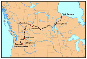
Every year ships would come from London and India, (via the Pacific) to drop off supplies and trade goods in exchange for the furs. It was also accessed from London twice annually via Hudson Bay and the York Factory Express trade route. Fort Vancouver was the nexus for the fur trade on the Pacific Coast; its influence reached from Rupert's Land and the Rocky Mountains in the east to the Hawaiian Islands, and from Russian Alaska to Mexican California. At its pinnacle in the late 1830s and early 1840s, Fort Vancouver watched over 34 outposts, 24 ports, six ships, and 600 employees.
Early American activity in the region included Fort William on present day Sauvie Island, the establishment of the Methodist Mission in the Willamette Valley and the Whitman Mission east of the Cascades,[2] a saw mill in the Willamette Valley partly owned by Ewing Young,[3] a grist mill also in the valley built in 1834,[4] the Willamette Cattle Company organized in 1837 to bring over 600 head of cattle to the Willamette Valley, as well as ongoing Maritime Fur Trade vessels.
Since the HBC officially discouraged settlement because it interfered with the lucrative fur trade, negotiations over the decades failed to settle upon a compromise boundary along the Columbia River. Strained relationships grew worse as American settlers began trickling into the region in the 1830s, and tensions escalated when settlers started arriving in large numbers in the 1840s along the Oregon Trail.
Joint occupation
The dispute arose as a result of competing claims between the United States and the United Kingdom to the Oregon Country, which consisted of what is now the Pacific Northwest of the United States and southern British Columbia, Canada. Both nations claimed the region based on earlier exploration and the "right of discovery". Following long European precedent, both sides recognized only limited sovereign rights of the indigenous population.
In 1818, diplomats of the two countries attempted to negotiate a boundary between the rival claims. The Americans suggested dividing the Oregon Country along the 49th parallel, which was the border between the United States and British North America east of the Rocky Mountains. British diplomats wanted a border further south along the Columbia River, so as to maintain the North West Company"s (later the Hudson's Bay Company) control of the lucrative fur trade along that river. As a compromise, the Anglo-American Convention of 1818 (or Treaty of 1818), which settled most other disputes from the War of 1812, called for the joint occupation of the region for ten years. As the expiration of the ten-year agreement approached, a second round of negotiations from 1825 to 1827 failed to resolve the issue, and so the joint occupation agreement was renewed, this time with the stipulation that a one-year notice had to be given when either party intended to abrogate the agreement.
Early in the 1840s, negotiations that produced the 1842 Webster-Ashburton Treaty (a border settlement in the east) addressed the Oregon question once again. British negotiators still pressed for the Columbia River boundary, which the Americans would not accept since it would deny the U.S. an easily accessible deep water port on the Pacific Ocean, and so no adjustment to the existing agreement was made. By this time, American settlers were steadily pouring into the region along the Oregon Trail, a development that some observers—both British and American—realized would eventually decide the issue.
The HBC belatedly reversed its policy on colonization. In 1841, on orders from HBC Governor Sir George Simpson, James Sinclair guided nearly 200 settlers from the Red River Colony west in an attempt to retain the area for Britain.
In 1843, John C. Calhoun famously declared that the U.S. government should pursue a policy of "wise and masterly inactivity" in Oregon, letting settlement determine the eventual boundary. That year over 700 U.S settlers arrived via the Oregon Trail in the "Great Migration". The Provisional Government of Oregon was established that year. Many of Calhoun's fellow Democrats, however, soon began to advocate a more direct approach.[5]
Election of 1844
Important figures in the Oregon question United States United Kingdom James K. Polk
PresidentRobert Peel
Prime MinisterJames Buchanan
Secretary of StateEarl of Aberdeen
Foreign SecretaryLouis McLane
Minister to the UKRichard Pakenham
Minister in WashingtonAt the 1844 Democratic National Convention, the party platform called for the annexation of Texas and asserted that the United States had a "clear and unquestionable" claim to "the whole" of Oregon and "that no portion of the same ought to be ceded to England or any other power." By informally tying the Oregon dispute to the more controversial Texas debate, the Democrats appealed to both Northern expansionists, who were more adamant about the Oregon boundary, and Southern expansionists, who focused on annexing Texas. Democratic candidate James K. Polk went on to win a narrow victory over Whig candidate Henry Clay, in part because Clay had taken a stand against expansion. "Fifty-four Forty or Fight!" was not yet coined during this election; one actual Democratic campaign slogan from this election (used in Pennsylvania) was the more mundane "Polk, Dallas, and the Tariff of '42".[6]
In his March 1845 inaugural address, President Polk quoted from the party platform, saying that the U.S. title to Oregon was "clear and unquestionable". Tensions grew, with both sides moving to strengthen border fortifications in anticipation of war. Despite Polk's bold language, he was actually prepared to compromise, and had no real desire to go to war over Oregon. He believed that a firm stance would compel the British to accept a resolution agreeable to the United States, writing that "the only way to treat John Bull was to look him straight in the eye". But Polk's position on Oregon was not mere posturing: he genuinely believed that the U.S. had a legitimate claim to the entire region. He rejected British offers to settle the dispute through arbitration, fearing that no impartial third party could be found.[7]
Prime Minister Robert Peel's Foreign Secretary, the Earl of Aberdeen, also had no intention of going to war over a region that was of diminishing economic value to the United Kingdom. Furthermore, the United States was an important trading partner. With the onset of famine in Ireland, the United Kingdom faced a food crisis, and had an increasing need for American wheat. Aberdeen had already decided to accept the U.S. proposal for a boundary along the 49th parallel, and he instructed Richard Pakenham, his minister in the U.S., to keep negotiations open.
On the other hand, Aberdeen and Pakenham were negotiating from a position of strength. The key was the overwhelming naval power which Britain could have brought to bear against the United States, combined with a diplomatic and political landscape that ultimately favored the British government's aim of protecting her interests robustly but without resort to armed conflict. Local interests were protected by the 80-gun ship-of-the-line HMS Collingwood under the CinC Rear Admiral Sir George Seymour. During the crisis his squadron was augmented by HMS America (74 guns), under the command of Captain John Gordon (younger brother of the Foreign Secretary), an officer whose misjudgement during the crisis – in contrast to Seymour’s exemplary behavior – led to his court-martial and reprimand.
Ultimately British politicians and naval officers recognized that any conflict over the Oregon boundary, however undesirable, would be decided, like the War of 1812, on the Eastern Seaboard of the U.S. and the Great Lakes. It was here that the full influence of British naval dominance could be brought to bear and it was this influence that played most strongly upon American decision-making during the crisis, especially their decision to compromise. From London, McLane reported that the British were prepared “to commission immediately some thirty ships-of-the-line in addition to steamers and other vessels held in reserve.” Polk’s bluff had been called.
Against this background, skillful diplomacy by the Peel government offered Polk the chance to back down, which was a course he accepted. A repeat of the War of 1812 was not on anyone’s agenda, and with no prospect of French support over such a trivial point Polk had little choice.
Whilst the Hudson’s Bay Company gradually lost commercial dominance over Oregon, the company’s interests were increasingly turning towards shipping which rendered the Columbia River less important than Vancouver Island. Shipping and trade interests could be protected by the development of the Esquimalt naval base and RN squadron based there.
Although the Royal Navy’s presence locally may not have been superior, vast overall superiority to the U.S. Navy enabled Britain’s politicians to secure their central objective of defeating the wild assertions of American politicians, retaining Vancouver island and avoiding a potentially costly, distracting war with a major trading partner at seemingly small cost at a time when the European continental balance was a far more pressing issue.[8]
A complicating factor in the negotiations was the issue of navigation on the Columbia River. Polk's predecessor, John Tyler, had offered the British unrestricted navigation on the river if they would accept a boundary along the 49th parallel. In the summer of 1845, the Polk administration renewed the proposal to divide Oregon along the 49th parallel, but this time without conceding navigation rights. Because this proposal fell short of the Tyler administration's earlier offer, Pakenham rejected the offer without first contacting London. Offended, Polk officially withdrew the proposal on August 30, 1845 and broke off negotiations. Aberdeen censured Pakenham for this diplomatic blunder, and attempted to renew the dialogue. By then, however, Polk was suspicious of British intentions, and under increasing political pressure not to compromise. He declined to reopen negotiations.[9]
Slogans and war crisis
 Senator Lewis Cass was a leading advocate of 54°40′, but backed away from the claim when it became untenable. Like James Buchanan, Cass had presidential ambitions and did not want to alienate Americans on either side of the Oregon question.
Meanwhile, many newspaper editors in the United States clamoured for Polk to claim the entire region as the Democrats had proposed in the 1844 campaign. Headlines like "The Whole of Oregon or None" appeared in the press by November 1845. In a column in the New York Morning News on December 27, 1845, editor John L. O'Sullivan argued that the United States should claim all of Oregon "by the right of our manifest destiny to overspread and to possess the whole of the continent". Soon afterwards, the term "Manifest Destiny" became a standard phrase for expansionists, and a permanent part of the American lexicon. O'Sullivan's version of "Manifest Destiny" was not a call for war, but such calls were soon forthcoming.
In his annual address to Congress on December 2, 1845, Polk recommended giving the British the required one-year notice of the termination of the joint occupation agreement. In Congress, Democratic expansionists from the Midwest, led by Senators Lewis Cass of Michigan, Edward A. Hannegan of Indiana, and William Allen of Ohio, called for war with the United Kingdom rather than accepting anything short of all of Oregon up to Parallel 54°40′ north. (54°40′ was then the southern boundary of the Russian claim to Alaska.) The slogan "Fifty-Four Forty or Fight" appeared by January 1846, driven in part by the Democratic press. The phrase is frequently misidentified as a campaign slogan from the election of 1844, even in many textbooks. Bartlett's Familiar Quotations attributes the slogan to William Allen.[10]
The calls to war were fueled by a number of factors, including traditional distrust of the British and a belief that the U.S. had the better claim and would make better use of the land. Moderates warned that the U.S. could not win a war against the world's greatest power, and that negotiation could still achieve U.S. territorial goals. Although the debate in the U.S. was not strictly divided along party or sectional lines, many who clamored for the 54°40′ border were Northerners upset that Polk, a Southern slave owner, had been uncompromising in his pursuit of Texas, a cause deemed favorable to Southern slave owners, but willing to compromise on Oregon. As historian David M. Pletcher noted, "Fifty-Four Forty or Fight" seemed to be directed at the southern aristocracy in the U.S. as much as at the United Kingdom.[11]
Resolution and treaty
Main article: Oregon Treaty The Oregon Territory, as established after the Oregon Treaty.
Although Polk had called on Congress in December 1845 to pass a resolution notifying the British of the termination of joint occupancy agreement, it was not until April 23, 1846 that both houses complied. The passage was delayed (especially in the Senate) by contentious debate, and ultimately a mild resolution was approved, the text of which called on both governments to settle the matter amicably. By a large margin, moderation had won out over calls for war. Unlike Western Democrats, most Congressmen—like Polk—did not want to fight for 54° 40'. [12]
The Polk administration then made it known that the British government should offer terms to settle the issue. Time was of the essence, because it was well known that the Peel government would fall with the impending repeal of the corn laws in the United Kingdom, and then negotiations would have to begin again with a new ministry. Aberdeen and Louis McLane, the American minister in the United Kingdom, quickly worked out a compromise and sent it to the United States. There, Pakenham and U.S. Secretary of State James Buchanan drew up a formal treaty, known as the Oregon Treaty, which was ratified by the Senate on June 18, 1846 by a vote of 41–14. The border was set at the 49th parallel, the original U.S. proposal, with navigation rights on the Columbia River granted to British subjects living in the area. Senator William Allen, one of the most outspoken advocates of the 54° 40' claim, felt betrayed by Polk and resigned his chairmanship of the Foreign Relations Committee.
The terms of the Oregon Treaty were essentially the same ones that had been offered earlier by the Tyler administration, and thus represented a diplomatic victory for Polk. However, Polk has often been criticized for his handling of the Oregon question. Historian Sam W. Haynes characterizes Polk's policy as "brinkmanship" which "brought the United States perilously close to a needless and potentially disastrous conflict". David M. Pletcher notes that while Polk's bellicose stance was the by-product of internal American politics, the war crisis was "largely of his own creation" and might have been avoided "with more sophisticated diplomacy".[13]
Ambiguities in the wording of the Oregon Treaty regarding the route of the boundary, which was to follow "the deepest channel" out to the Strait of Juan de Fuca and beyond to the open ocean resulted in the Pig War; another boundary dispute in 1859 over the San Juan Islands. The dispute was peacefully resolved after a decade of confrontation and military bluster during which the local British authorities consistently lobbied London to seize back the Puget Sound region entirely, as the Americans were busy elsewhere with the Civil War. The San Juan's dispute was not resolved until 1872; when the pursuant to the Treaty of Washington (1871) an arbitrator (the German Emperor) chose the American-preferred marine boundary via Haro Strait, to the west of the islands, over the British preference for Rosario Strait which lay to their east.
Upper Canada politicians and public, already angry with the Oregon Treaty, were once again upset that Britain had not looked after their interests and sought greater autonomy in international affairs.
Historical maps
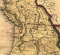
The boundary between British and American territory was shown differently in maps at the time:
-
An 1844 British map showing the Columbia River as the boundary
-
An 1846 map showing the 49th parallel as the boundary through Vancouver Island
See also
- Adams-Onís Treaty of 1819, between U.S. and Spain, resolved borders from Florida to the Pacific Ocean.
- Alaska boundary dispute, mid-to-late-19th century, resolved in 1903, resolved border between Alaska and British Columbia.
- Pig War
- Webster-Ashburton Treaty of 1842, primarily concerned the border between Maine and New Brunswick, but reaffirmed other aspects of the U.S.–Canadian border.
Notes
- ^ Mackie, Richard Somerset (1997). Trading Beyond the Mountains: The British Fur Trade on the Pacific 1793-1843. Vancouver: University of British Columbia (UBC) Press. pp. 29, 124–126, 140. ISBN 0-7748-0613-3. online at Google Books
- ^ Oregon History: Land-based Fur Trade and Exploration
- ^ Ewing Young Route. compiled by Karen Bassett, Jim Renner, and Joyce White.
- ^ Salem Online History: Salem's Historic Figures
- ^ Pletcher, pp. 109–110. The phrase "wise and masterly inactivity", which Calhoun used more than once, originated with Sir James Mackintosh. (source)
- ^ Rosenboom, p. 132.
- ^ Polk did not desire war, believed the Oregon claim: Haynes, p. 118. John Bull quote: Pletcher, p. 328. Rejects arbitration: Pletcher, p. 322.
- ^ Gough, Barry M., The Royal Navy and the Northwest Coast of North America, 1810-1914 University of British Columbia Press, Vancouver. 1971. pp. 70-83
- ^ Pletcher, pp. 237–249, 296–300; Haynes, pp. 118–120.
- ^ Both Pletcher (p. 223) and Rosenboom (p. 132) note that the slogan was not used in the election. Pletcher also notes that many textbooks get this wrong. See also E.A. Miles, "Fifty-Four Forty or Fight": an American Political Legend, Mississippi Valley Historical Review 44(2), September 1957, pp. 291–309, and Hans Sperber, "Fifty-four Forty or Fight": Facts and Fictions, American Speech 32(1), February 1957, pp. 5–11.
- ^ Pletcher, pp. 335–37.
- ^ Pletcher, pp. 351.
- ^ Diplomatic victory for Polk, Haynes p. 136; brinkmanship, Haynes p. 194; Pletcher quote, p. 592.
References
- Haynes, Sam W. James K. Polk and the Expansionist Impulse. Arlington: University of Texas, 1997.
- Pletcher, David M. The Diplomacy of Annexation: Texas, Oregon, and the Mexican War. Columbia, Missouri: University of Missouri Press, 1973.
- Rosenboom, Eugene H. A History of Presidential Elections: From George Washington to Richard M. Nixon. Third edition. New York: Macmillan, 1970.
External links
Party platform and speeches
- 1844 Democratic platform, which asserted that the U.S. "title to the whole of the Territory of Oregon is clear and unquestionable"
- Polk's March 1845 inaugural address, in which he reasserted the "clear and unquestionable" claim
- Polk's December 1845 message to Congress, in which he called for the end of the joint occupation of Oregon
Political cartoons from Harper's Weekly, 1846
- "Polk's Dream", in which the Devil, disguised as Andrew Jackson, advises Polk to fight for the 54°40′ line
- "Present Presidential Position", in which the Democratic Party's "jackass" is standing on the 54°40′ line
- "Ultimatum on the Oregon Question", Polk talks with Queen Victoria, while others make comments
- "War! or No War!", two Irish immigrants face off over the boundary question
Other
- Fifty-Four Forty or Fight at About.com, an example of a reference that mistakenly describes the phrase as an 1844 campaign slogan
- Another reference work that mistakenly ascribes the slogan Fifty-Four Forty or Fight to Polk is the Encyclopædia Britannica. URL last accessed December 16, 2005.
- 54-40 or Fight shows the quilt block named after the slogan. In this time period, women frequently used quilts to express their political views.
Further reading
- Sir James Douglas, Chapter V The Oregon Boundary, Robert Hamilton Coats and R. Edward Gosnell , publ. Morang, Toronto, 1908
Categories:- History of the Pacific Northwest
- History of British Columbia
- Pre-state history of Oregon
- History of United States expansionism
- Oregon Country
- Pacific Northwest
- Canada–United States border disputes
- Pre-state history of Wyoming
- Pre-state history of Idaho
- United Kingdom–United States relations
- Presidency of James K. Polk
Wikimedia Foundation. 2010.

