- Pig War
-
For the trade conflict between the Austro-Hungarian Empire and Serbia, see Pig War (Serbia).
Pig War 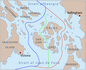
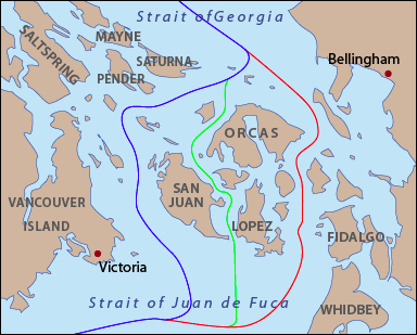
Proposed boundaries:
Through Haro Strait, favored by the US Through Rosario Strait, favored by Britain Through San Juan Channel, compromise proposal The curved lines are as shown on maps of the time. The modern boundary is made of straight line segments and roughly follows the blue line. The modern eastern boundary of San Juan County roughly follows the red line.
Date June 15 – October 1859 (troops stationed on San Juan Island until 1874) Location San Juan Islands Result San Juan Islands awarded to the United States following third party arbitration Belligerents  United States
 United Kingdom
Commanders and leaders Colonel Silas Casey Rear Admiral R. L. Baynes Strength 461 combatants, 14 cannons 2,140 combatants; 5 warships mounting 70 cannons Casualties and losses 0 combatants 0 combatants The Pig War was a confrontation in 1859 between the United States and the British Empire over the boundary between the US and British North America. The territory in dispute was the San Juan Islands, which lie between Vancouver Island and the North American mainland. The Pig War, so called because it was triggered by the shooting of a pig, is also called the Pig Episode, the Pig and Potato War, the San Juan Boundary Dispute or the Northwestern Boundary Dispute. The pig was the only casualty of the war, making the dispute otherwise bloodless.
Contents
Background
The Oregon Treaty of June 15, 1846, resolved the Oregon boundary dispute by dividing the Oregon Country/Columbia District between the United States and Britain "along the forty-ninth parallel of north latitude to the middle of the channel which separates the continent from Vancouver Island, and thence southerly through the middle of the said channel, and of Juan de Fuca Strait, to the Pacific Ocean.[1]"
However, there are actually two straits which could be called the middle of the channel: Haro Strait, along the west side of the San Juan Islands; and Rosario Strait, along the east side.[2]
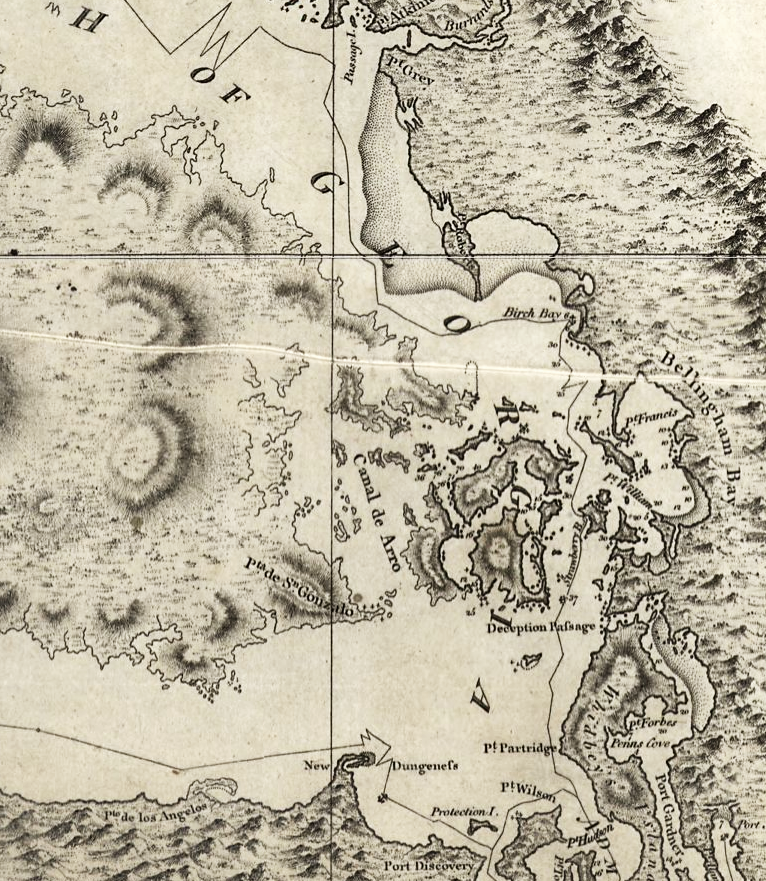
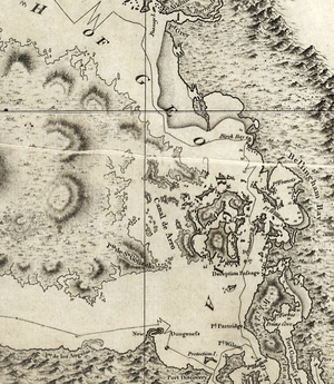 Vancouver's 1798 map, showing some confusion in the vicinity of southeastern Vancouver Island, the Gulf Islands, and Haro Strait
In 1846 there was still some uncertainty about the geography of the region. The most commonly available maps were those of George Vancouver, published in 1798, and of Charles Wilkes, published in 1845. In both cases the maps are unclear in the vicinity of the southeastern coast of Vancouver Island and the Gulf Islands. As a result, Haro Strait is not fully clear either.[3]
In 1856 the US and Britain set up a Boundary Commission to resolve a number of issues regarding the international boundary, including the water boundary from the Strait of Georgia to the Strait of Juan de Fuca. The British appointed James Charles Prevost First Commissioner, George Henry Richards Second Commissioner, and William A.G. Young Secretary. The US appointed Archibald Campbell First Commissioner, John Parke Second Commissioner, and William J. Warren Secretary. The two sides met several times in 1857 in Esquimalt Harbour and Nanaimo Harbour, and corresponded by letter between meetings. The water boundary was discussed from October to December. From the start Prevost maintained that Rosario Strait was required by the treaty's wording and was intended by the treaty framers, while Campbell had the same opinion for Haro Strait. Prevost held that the channel specified in the treaty must have three key qualities: It must separate the continent from Vancouver Island, it must carry the boundary in a southerly direction, and it must be navigable. Only Rosario fulfilled these requirements, he wrote. Campbell countered that the expression "southerly", in the treaty, was to be understood in a general sense, that Rosario Strait did not separate the continent from Vancouver Island, but the San Juan Islands from Lummi Island, Cypress Island, Fidalgo Island, and others, and that navigability was not germane to the issue, but even if it was, Haro Strait was the wider and more direct passage. Finally he challenged Prevost to produce any evidence showing that the treaty framers had intended Rosario Strait. Prevost responded to the challenge by referring to American maps showing the boundary running through Rosario Strait, included one by John C. Frémont, produced for and published by the US government, and another by John B. Preston, Surveyor-General of Oregon in 1852. To the other points, Prevost repeated his statements about Rosario Strait's navigability—the channels between Lummi, Cypress, and Fidalgo islands not being navigable—and that a line through Rosario would be southerly, while one through Haro would have to be drawn westerly. The two continued to discuss the issue into December 1857, until it was clear what each side's argument was and that neither would be convinced of the other. Prevost made a final offer at the sixth meeting, December 3. He suggested a compromise line through San Juan Channel, which would give the US all the main islands except San Juan Island. This offer was rejected and the commission adjourned, agreeing to report back to their respective governments. Thus ambiguity over the water boundary remained.[4]
Because of this ambiguity, both the United States and Britain claimed sovereignty over the San Juan Islands.[5] During this period of disputed sovereignty, Britain's Hudson's Bay Company established operations on San Juan and turned the island into a sheep ranch. Meanwhile by mid-1859, twenty-five to twenty-nine American settlers had arrived.[2][6]
San Juan Island held significance not for its size, but as a military strategic point. While the British held Fort Victoria on Vancouver Island to the west, overlooking the Strait of Juan de Fuca, the entry point to Haro Strait, leading to the Strait of Georgia, the nation that held the San Juan Islands would be able to dominate all the straits connecting the Strait of Juan de Fuca with the Strait of Georgia.[citation needed]
The pig
On June 15, 1859, exactly thirteen years after the adoption of the Oregon Treaty, the ambiguity led to direct conflict. Lyman Cutlar, an American farmer who had moved onto the island claiming rights to live there under the Donation Land Claim Act, found a large black pig rooting in his garden.[2][5][7] He had found the pig eating his tubers. This was not the first occurrence. Cutlar was so upset that he took aim and shot the pig, killing it. It turned out that the pig was owned by an Irishman, Charles Griffin, who was employed by the Hudson's Bay Company to run the sheep ranch.[2][5][7] He also owned several pigs which he allowed to roam freely. The two had lived in peace until this incident. Cutlar offered $10 to Griffin to compensate for the pig, but Griffin was unsatisfied with this offer and demanded $100. Following this reply, Cutlar believed he should not have to pay for the pig because the pig had been trespassing on his land. (A possibly apocryphal story claims Cutlar said to Griffin, "It was eating my potatoes". Griffin replied, "It is up to you to keep your potatoes out of my pig"[7]). When British authorities threatened to arrest Cutlar, American settlers called for military protection.
Military escalation
Brigadier-General William S. Harney, commanding the Dept. of Oregon, initially dispatched 66 American soldiers of the 9th Infantry under the command of Captain George Pickett to San Juan Island with orders to prevent the British from landing.[2][5] Concerned that a squatter population of Americans would begin to occupy San Juan Island if the Americans were not kept in check, the British sent three warships under the command of Captain Geoffrey Hornby to counter the Americans.[2][5][7] Pickett was famously quoted as saying defiantly, "We'll make a Bunker Hill of it," placing him in the national limelight. [8] The situation continued to escalate. By August 10, 1859, 461 Americans with 14 cannons under Colonel Silas Casey were opposed by five British warships mounting 70 guns and carrying 2,140 men.[2][5][7] During this time, no shots were fired.
The governor of the Colony of Vancouver Island, James Douglas, ordered British Rear Admiral Robert L. Baynes to land marines on San Juan Island and engage the American soldiers under the command of Brigadier-General Harney. (Harney's forces had occupied the island since July 27, 1859.) Baynes refused, deciding that "two great nations in a war over a squabble about a pig" was foolish.[5][7] Local commanding officers on both sides had been given essentially the same orders: defend yourselves, but absolutely do not fire the first shot. For several days, the British and U.S. soldiers exchanged insults, each side attempting to goad the others into firing the first shot, but discipline held on both sides, and thus no shots were fired.
Resolution
When news about the crisis reached Washington and London, officials from both nations were shocked and took action to calm the potentially explosive international incident.[9]
In September, U.S. President James Buchanan sent General Winfield Scott to negotiate with Governor Douglas and resolve the growing crisis.[5][7] This was in the best interest of the United States, as sectional tensions within the country were increasing, soon to culminate in the Civil War.[7] Scott had calmed two other border crises between the two nations in the late 1830s. He arrived in the San Juans in October and began negotiations with Douglas.[9]
As a result of the negotiations, both sides agreed to retain joint military occupation of the island until a final settlement could be reached, reducing their presence to a token force of no more than 100 men.[5] The "British Camp" was established on the north end of San Juan Island along the shoreline, for ease of supply and access; and the "American Camp" was created on the south end on a high, windswept meadow, suitable for artillery barrages against shipping.[7] Today the Union Jack still flies above the "British Camp", being raised and lowered daily by park rangers, making it one of the very few places without diplomatic status where US government employees regularly hoist the flag of another country.
During the years of joint military occupation, the small British and American units on San Juan Island had a very amicable mutual social life, visiting one another's camps to celebrate their respective national holidays and holding various athletic competitions. Park rangers tell visitors the biggest threat to peace on the island during these years was "the large amounts of alcohol available."
This state of affairs continued for the next 12 years. The dispute was peacefully resolved after more than a decade of confrontation and military bluster, during which time the local British authorities consistently lobbied London to seize back the Puget Sound region entirely, as the Americans were busy elsewhere with the Civil War. In 1871 Great Britain and the United States signed the Treaty of Washington, which dealt with various differences between the two nations, including border issues with the newly formed Dominion of Canada. Among the results of the treaty was the decision to resolve the San Juan dispute by international arbitration, with Kaiser Wilhelm I of Germany chosen to act as arbitrator. Wilhelm referred the issue to a three-man arbitration commission which met in Geneva for nearly a year.[9] On October 21, 1872, the commission decided in favor of the United States.[2][5][7] The arbitrator chose the American-preferred marine boundary via Haro Strait, to the west of the islands, over the British preference for Rosario Strait which lay to their east.
On November 25, 1872, the British withdrew their Royal Marines from the British Camp.[2] The Americans followed by July 1874.[2][5]
Canadian politicians and public, already angry with the Oregon Treaty, were once again upset that Britain had not looked after their interests, and Canada sought greater autonomy in international affairs.
The Pig War is commemorated in San Juan Island National Historical Park.[7]
Key figures
- Henry Martyn Robert who later published Robert's Rules of Order was stationed on the island for much of the period.[10]
- Captain George Pickett, later of Pickett's Charge fame, was in charge of the initial American landing force.[10]
- Captain Geoffrey Hornby, commander of the initial British naval force deployed, would later be promoted to Admiral of the Fleet, the highest rank in the Royal Navy, and earned a reputation as a pre-eminent tactician and fleet commander.
In popular culture
An episode of Hey Arnold! was based on the Pig War (Season 3, Episode 16).
See also
- Aroostook War, the "Northeastern Boundary Dispute"
- List of conflicts in the United States
- List of conflicts in Canada
- Military history of Canada
- Military history of the United Kingdom
- Military history of the United States
- Point Roberts
- War of the Stray Dog, a brief war that began under similar circumstances.
References
- ^ Oregon Treaty from Wikisource. Visited October 16, 2006.
- ^ a b c d e f g h i j Matthews, Todd. "The Pig War of San Juan Island", The Tablet.
- ^ Hayes, Derek (1999). Historical Atlas of the Pacific Northwest: Maps of exploration and Discovery. Sasquatch Books. pp. 171–174. ISBN 1-57061-215-3.
- ^ Scholefield, Ethelbert Olaf Stuart; Howay, Frederic William (1914). British Columbia from the earliest times to the present. Vol. 2. The S.J. Clarke publishing company. pp. 303–306. OCLC 697901687. http://books.google.com/books?id=vGdJtwAACAAJ. Retrieved 22 June 2011.
- ^ a b c d e f g h i j k "The Pig War". National Park Service, U.S. Department of the Interior. http://www.nps.gov/archive/sajh/Pig_War_new.htm. Retrieved 2006-10-16.
- ^ British Columbia: From the earliest times to the present, Vol II by E.O.S. Scholefield and F.W. Howay
- ^ a b c d e f g h i j k Woodbury, Chuck (2000). "How One Pig Could Have Changed American History". Out West #15 (Out West Newspaper). http://www.outwestnewspaper.com/pigwars.html. Retrieved 2006-10-16.
- ^ Tagg, Larry (1998). "The Generals of Gettysburg". Savas Publishing. http://www.rocemabra.com/~roger/tagg/generals/. Retrieved June 14, 2010.
- ^ a b c "The Pig War". San Juan Island National Historical Park. National Park Service. http://www.nps.gov/sajh/historyculture/the-pig-war.htm. Retrieved 2009-06-19.
- ^ a b Vouri, Michael (1999). The Pig War: Standoff at Griffin Bay. Griffin Bay. pp. 273. ISBN 978-0963456250.
Further reading
- Coleman, E C (2009). The Pig War: The Most Perfect War in History. The History Press. ISBN 978 0 75245227 2.
External links
- The Pig War, National Park Service
- The Pig War of San Juan Island
- Lyman Cutlar touches off Pig War between U.S. and Great Britain on June 15, 1859, HistoryLink.org
Coordinates: 48°27′41.91″N 123°00′23.81″W / 48.4616417°N 123.0066139°W
Categories:- Conflicts in 1859
- History of British Columbia
- History of Washington (state)
- Military history of Canada
- Canada–United States border disputes
- History of the Pacific Northwest
- Conflicts in Canada
- Diplomatic incidents
- Coast of British Columbia
- Arbitration cases
- Battles and conflicts without fatalities
Wikimedia Foundation. 2010.