- Continental Divide Trail
-
Continental Divide Trail 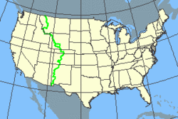
Length 3,100 miles (5,000 km) Location United States Trailheads Glacier National Park (U.S.)
Antelope Wells, New Mexico United States-Mexico borderUse Hiking
some Horse riding
some Mountain bikingElevation Change ??? Highest point Grays Peak, Colorado 14,270 feet (4,350 m) Lowest point Columbus, New Mexico 3,900 feet (1,200 m) Trail difficulty Moderate to Strenuous Months April to October Sights Continental Divide Hazards Severe Weather
Hypothermia
Lightning
Falls
Avalanche
Dehydration
Bears
Mountain lionsThe Continental Divide National Scenic Trail (in short Continental Divide Trail) is a United States National Scenic Trail running 3,100 miles (5,000 km) between Mexico and Canada. It follows the Continental Divide along the Rocky Mountains and traverses five U.S. states — Montana, Idaho, Wyoming, Colorado, and New Mexico. In Montana it crosses Triple Divide Peak which separates the Hudson Bay, Atlantic Ocean and Pacific Ocean drainages.
In 2004, the trail, a combination of dedicated trails and small roads, was considered 70% complete. The uncompleted portions of the trail must be traveled by bushwhacking or roadwalking.
Only about two dozen people a year attempt to hike the entire trail, taking about six months to complete it. As of 2008, no equestrians have managed to ride the entire trail in a single year, although several "long riders" have tried.[citation needed] German long distance rider Günter Wamser (on his way from Tierra del Fuego to Alaska[1]), and Austrian Sonja Endlweber (who joined him for the rest of the journey from Mexico) managed to complete the tour with four Bureau of Land Management mustangs in three summers 2007–2009.[2]
In 2007, Francis Tapon became the first person to do a round backpacking trip on the Continental Divide Trail when he thru-hiked from Mexico to Canada and back to Mexico along the CDT and needed 7 months to finish it.[3][4][5][6]
The Continental Divide Trail along with the Appalachian Trail and the Pacific Crest Trail form the Triple Crown of long distance hiking in the United States.
This trail can be continued above the Canadian border to Kakwa Lake north of Jasper National Park by the Great Divide Trail, which is so far described only in a few books and carries no official Canadian status.
Contents
New Mexico
The CDT in New Mexico is about 700 miles (1,100 km) long and some portions have very limited water.[7] Local volunteer groups place water caches (usually a pile of plastic gallon jugs) at strategic points along the trail.[8][9] Three southern termini of the trail exist: Crazy Cook Monument, Antelope Wells and near Columbus, all in New Mexico's boot heel. The terminus near Columbus is not on the Continental Divide (see Animas Mountains) but rather in the vicinity of Columbus, New Mexico, a village that is also the northern terminus of the annual 250-mile (400 km) Cabalgata Binacional Villista.
Notable points on the CDT in New Mexico include:
- Animas and Playas Valleys
- Carson National Forest
- Chama River Canyon Wilderness
- Cibola National Forest
- Cumbres Pass
- El Malpaís National Monument
- Ghost Ranch
- Gila National Forest
- Pie Town
- Reserve
- San Pedro Parks Wilderness
- Santa Fe National Forest
Colorado
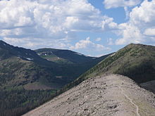
The CDT passes through many of the highest and wildest mountain regions of Colorado, such as the San Juan Mountains and the Sawatch Range. In most areas the trail is well marked. It is concurrent with the Colorado Trail for approximately 200 miles. The Continental Divide itself in Colorado meanders some 650 miles. There are many stretches of the Continental Divide in Colorado that have no distinct marked or named trail. The Continental Divide Trail only covers a portion of the Continental Divide in Colorado. Many stretches of the Continental Divide in Colorado are still a wilderness to even a footpath.
Wyoming
The CDT includes a large section of rangeland in the middle of the state, as well as the Wind River Range and Tetons in the northwest portion of Wyoming. The CDT traverses a large portion of the southern half of Yellowstone National Park. Hikers must decide on a route with regard to the Great Divide Basin at the southern end of the state. The shortest route is through the middle, and water availability is uncertain in most years.
Montana
The Montana portion of the CDT is almost entirely in the mountains. 110 miles (177 km) of the CDT traverses most of Glacier National Park north to south.
See also
- Great Divide Mountain Bike Route - parallel, sometimes shared tread
- Colorado Trail - the two trails coincide for about 200 miles (320 km)
- Pacific Northwest Trail - Shares a common start/end point with the CDT in Glacier National Park.
External links
- Continental Divide Trail Alliance website
- CDT Society website
- Jonathan Ley's CDT Hike - a hiker's website
- Beaverhead-Deerlodge National Forest web site - Describes the northernmost parts of the trail
- CDT-L - Continental Divide Trail Mailing List
- CDT Thruhiking Resources - Listing of important resources to thruhike the CDT
- Google Map of CDT High Resolution Google Map of CDT
- A Quick & Dirty CDT Planning Guide - A general overview of the CDT for planning purposes
- Francis Tapon's CDT Yo-Yo hike - a website of the first person who made a roundtrip on the CDT
References
- ^ Wamser, Günter (2007) Der Abenteuerreiter - In 11 Jahren mit Hund und Pferden von Feuerland nach Mexico Verlag Günter Wamser, 384 pages, ISBN 978-3000215278.
- ^ Wamser, Günter / Endlweber, Sonja (2009) Im Wilden Westen - Die Abenteuerreiter unterwegs in den Rocky Mountains Verlag Abenteuerreiter, 432 pages, ISBN 978-3000277023.
- ^ M. Biggers, Ashley. "There & Back Again". New Mexico Magazine. March 2008. Retrieved 27 November 2010.
- ^ Drabanski, Emily. "Hello, New Mexico". KSFR, Santa Fe Public Radio. Retrieved 27 November 2010.
- ^ Wilt, Bernie. "PBP Episode 31 - CDT Yo-Yo". PracticalBackpacking.com. Retrieved 27 November 2010.
- ^ Reese, Janet. "5 questions for long-distance hiker Francis Tapon". Rocky Mountain News. 19 June 2007. Retrieved 27 November 2010.
- ^ Bob Julyan, Tom Till, William Stone (2001) New Mexico's Continental Divide Trail: The Official Guide Big Earth Publishing, 320 pages, ISBN 1565793315.
- ^ "New Mexico". Continental Divide Trail Alliance. May 2008. http://www.cdtrail.org/page.php?pname=about/newmexico. Retrieved 2008-10-20.
- ^ "Continental Divide National Scenic Trail". Bureau of Land Management, New Mexico. http://www.blm.gov/nm/st/en/prog/recreation/continental_divide_nst.html. Retrieved 2008-10-20.
Categories:- National Scenic Trails of the United States
- Hiking trails in Montana
- Hiking trails in Idaho
- Hiking trails in Wyoming
- Hiking trails in Colorado
- Hiking trails in New Mexico
- Great Divide of North America
- Bootheel region of New Mexico
- Long-distance trails in the United States


Wikimedia Foundation. 2010.