- Cumbres Pass
-
Cumbres Pass Elevation 10,020 ft (3,054 m) [1] Traversed by  SH 17
SH 17Location Location Conejos County, Colorado, USA Range San Juan Mountains Coordinates 37°01′14″N 106°27′00″W / 37.02056°N 106.45°WCoordinates: 37°01′14″N 106°27′00″W / 37.02056°N 106.45°W Topo map USGS Cumbres Cumbres Pass, elevation 10,020 ft (3,050 m), is a mountain pass in the San Juan Mountains of Colorado. The pass is traversed by State Highway 17 and the Cumbres and Toltec Scenic Railroad. The highway has a moderate 5.8% approach on the north side and a gentler, 4% approach on the south side. It is rarely closed in winter and does not normally cause problems for vehicles, since the road is not a major through highway.
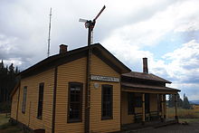
The railroad and Cumbres station were built in the 1880s by the Denver & Rio Grande Railroad. The original section house, car inspectors house, and remains of the old snowshed remain on Cumbres Pass, whereas the placement of the original station and other missing structures have yet to be determined by the Friends of the Cumbres and Toltec Scenic Railroad.
See also:
- Chama, NM
- Osier, CO
- Sublette Station
- Antonito, CO
References
Categories:- Mountain passes of Colorado
- Geography of Conejos County, Colorado
- Denver and Rio Grande Western Railroad
- Colorado geography stubs
Wikimedia Foundation. 2010.

