- Colorado State Highway 17
-
State Highway 17
Route information Maintained by CDOT Length: 88.5 mi[1]a[›] (142.4 km) Major junctions South end:  NM 17 at New Mexico state line
 runs concurrently with US 285 from Antonito to Alamosa
 US 160 at Alamosa, CO
 SH 112 near Hooper
North end: US 285 south of Villa GroveHighway system ←  SH 16
SH 16SH 21  →
→State Highway 17 is a 88.5 mi (142.4 km)a[›] long state highway in southern Colorado.
Contents
Route description
SH 17 is officially split into two parts by a stretch of concurrence with U.S. Highway 285. The first part of the route begins in the south at the New Mexico state line where the road becomes New Mexico State Road 17. From the state line the road proceeds in a winding, generally easterly path over the San Juan Mountains via Cumbres Pass and La Manga Pass, both over 10,000 ft (3,000 m) in elevation. Along this section, the road offers access to Rio Grande National Forest and the many recreational activities it offers. After leaving the national forest, the road continues east for approximately 13 more miles before merging with US 285 at Antonito. From Antonito, SH 17 runs northward concurrent with US 285 for just over thirty miles to the city of Alamosa. At Alamosa, the second part of SH 17 begins after the road splits from US 285. From there, the road proceeds northward up the middle of the San Luis Valley between the Sangre de Christo Mountains in the east and the San Juan Mountains to the west. The route passes through the towns of Mosca, Hooper (where the road meets the eastern end of State Highway 112,) and Moffat before reaching its northern terminus where it again meets US 285 roughly five miles south of Villa Grove.
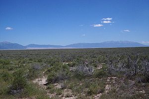 View from Highway 17 between Moffat and Hooper
History
When the route was established in 1920s, the route was broken into two sections. The road began at Pagosa Springs and began southeast and disappeared as the route ended at the New Mexico state line. The route then reappeared northeast and terminated at SH 15 (now moved) near Mineral Hot Springs. Within the northeast segment, the route from Antonito to Alamosa was paved by 1936. The portion of the eastern segment from the New Mexico state line to Antonito was deleted and readded by 1938 and 1946, respectively. The rest of the route, not included the segment from New Mexico to Antonito, was paved by 1954. In 1968, the sections of the highway that were concurrent with other highways were eliminated, leaving the two segments existent now. The route was paved by 1970.[2]
Major intersections
County Location Mile Destination Notes Archuleta 0.00 NM 17Conejos Antonito 39.05 US 285Begin concurrency Alamosa Alamosa 69.02 US 285 / US 160End concurrency Saguache Hooper 88.19 SH 112Mineral Hot Springs 118.86 US 2851.000 mi = 1.609 km; 1.000 km = 0.621 mi
Concurrency terminus • Closed/Former • Incomplete access • UnopenedOn the south side of Moffat there is a crossroads with Saguache County Road T. Crestone is 12.5 miles (20.1 km) east.
Gallery
-
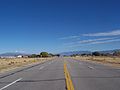
Highway 17 looking north toward Moffat from near Road T
Footnotes
^ a: The section of SH 17 which runs concurrent to US 285 is maintained with federal rather than state funds and is therefore not counted by the Colorado Department of Transportation in the road's official 88.5 mile length; the total end-to-end length including this segment is 118.8 mi (191.2 km).[1]
References
- ^ a b "Segment Descriptions for Highway 17". Colorado Department of Transportation. http://www.dot.state.co.us/app_DTD_DataAccess/Highways/index.cfm?fuseaction=Description&route=017&begRefPt=0&endRefPt=500&Printable=true. Retrieved 2008-03-26.
- ^ Salek, Matthew E.. "Colorado Routes 1-19". http://www.mesalek.com/colo/r1-19.html#17. Retrieved 2010-05-26.
Categories: -


Wikimedia Foundation. 2010.