- Congress Avenue
-
Congress Avenue Historic District
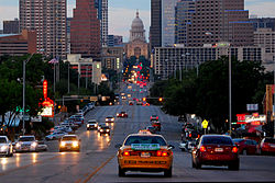
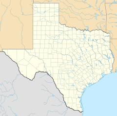
Location: Congress Ave. from 1st to 11th Sts., Austin, Texas Coordinates: 30°16′4″N 97°44′33″W / 30.26778°N 97.7425°WCoordinates: 30°16′4″N 97°44′33″W / 30.26778°N 97.7425°W Area: 38.3 acres (15.5 ha) Built: 1839 Architect: Multiple Architectural style: Late Victorian, Skyscraper Governing body: Local NRHP Reference#: 78002989[1] Added to NRHP: August 11, 1978 Congress Avenue is a major thoroughfare in Austin, Texas. The street is a six-lane, tree lined avenue that cuts through the middle of the city from far south Austin and goes over Lady Bird Lake leading to the Texas State Capitol in the heart of downtown.
Congress Avenue south of Lady Bird Lake is known as South Congress, often abbreviated to SoCo[2], and is an increasingly popular shopping and rental district. It passes the historic Travis Heights neighborhood, the Texas School for the Deaf, and St. Edward's University as it passes south out of town.
Contents
History
Edwin Waller, the first mayor of Austin, designed Congress Avenue to be Austin's most prominent street. Early structures along Congress Avenue included government buildings, hotels, saloons, retail stores and restaurants. By the late 1840s "The Avenue" formed a well-established business district. The mid-1870s introduced gaslight illumination and mule-driven streetcars as well as construction of a new Travis County courthouse at Eleventh Street. The present Texas Capitol at the north end of Congress Avenue was built in 1888. The original dirt street was bricked in 1910. Trolley cars operated on the Avenue until 1940.
Before Interstate 35 was completed in the 1960s, Congress Avenue was the primary road to reach Austin from the south. Certain landmarks such as the Austin Motel identify the road as a major thoroughfare for travellers through the mid-20th century.
Route description
Congress Avenue begins at an intersection with Slaughter Lane near Interstate 35. It heads to the north-northeast, diverging away from I-35. This portion of Congress from Slaughter Lane north to the Williamson Creek bridge is maintained by the Texas Department of Transportation and carries the Loop 275 designation. After the intersection with Stassney Lane, the road heads to the northeast, now parallel to I-35. Congress Avenue passes over the U.S. Highway 290 freeway as it travels to the northeast. Continuing to the northeast, it passes by St. Edward's University before crossing over Lady Bird Lake (Colorado River) by way of the Ann W. Richards Congress Avenue Bridge. The street continues northeast through downtown Austin to 11th Street at the Texas State Capitol. At the Capitol, it splits into a one-way pair, with the northbound lanes going around the east side of the Capitol, and the southbound lanes going around the west side. The street merges back to a 2-way street northeast of the Capitol and continues heading to the northeast. It continues for several more blocks before coming to an end at the University of Texas at Austin campus at Martin Luther King Jr Boulevard.[3]
Ann W. Richards Congress Avenue Bridge
The Ann W. Richards Congress Avenue Bridge over Lady Bird Lake houses the world's largest urban bat population. When the bridge was refurbished in the 1980s, the new design created crevices underneath the structure that happened to be ideal for bats to roost in. In the summer, the colony has up to 1.5 million Mexican Free-tailed Bats. The bats can be seen emerging by the thousands from under the bridge every evening throughout the summer, before they migrate to Mexico for the winter.[4]
Recognition
In recognition of its architectural and historical significance, Congress Avenue from First Street to the Capitol was listed in the National Register of Historic Places in 1979.
See also
References
- ^ "National Register Information System". National Register of Historic Places. National Park Service. 2009-03-13. http://nrhp.focus.nps.gov/natreg/docs/All_Data.html.
- ^ "South Congress Austin Neighborhood". http://austin.smallplanetguide.com/rentals/index.php?p=soco_austin_neighborhood.
- ^ Google Maps. Overview map of Congress Avenue (Map). http://maps.google.com/maps?f=d&hl=en&geocode=8286009480115144944,30.167170,-97.788520%3B7162311288853717040,30.226723,-97.761886%3B7610350267599324497,30.261777,-97.745119%3B3089691678164177306,30.273332,-97.740422%3B8729107765617997319,30.280370,-97.738200&saddr=S+Congress+Ave+%4030.167170,+-97.788520&daddr=S+Congress+Ave+%4030.226723,+-97.761886+to:Congress+Ave+S+%4030.261777,+-97.745119+to:Unknown+road+%4030.273332,+-97.740422+to:Congress+Ave+%4030.280370,+-97.738200&via=1,2,3&doflg=ptm&sll=30.22377,-97.76337&sspn=0.190748,0.212517&ie=UTF8&z=12. Retrieved 2008-03-12.
- ^ "Bat Conservation International page on the Congress Avenue Bridge Bat Colony". http://www.batcon.org/index.php/education/find-bat-locations/congress-avenue-bridge/subcategory.html?layout=subcategory.
City of Austin Counties Important
businessesHigher
educationMusic Antone's · Armadillo World Headquarters · Austin City Limits · Austin Lyric Opera · Austin Symphony Orchestra · Emo's · SXSW · Stevie Ray Vaughan · Willie NelsonLandmarks Austin-Bergstrom International Airport · Darrell K Royal-Texas Memorial Stadium · Dell Diamond · The Drag · Frank Erwin Center · Governor's Mansion · Lyndon Baines Johnson Library and Museum · Moonlight tower · Sixth Street · South Congress · State Capitol · Treaty Oak · UFCU Disch-Falk Field · University of Texas TowerParks and
preservesAuditorium Shores · Emma Long · Hippie Hollow · McKinney Falls · Mount Bonnell · Walnut Creek · Wild Basin · ZilkerBodies of
waterCategories:- Historic districts in Texas
- Neighborhoods in Austin, Texas
- Neighborhoods in Texas
- Transportation in Austin, Texas
- National Register of Historic Places in Texas
- National Register of Historic Places in Austin, Texas
- Streets in Texas
Wikimedia Foundation. 2010.


