- Mountcharles
-
Mountcharles
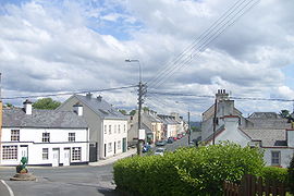
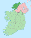
Tamhnach an tSalainn— Town — Location in Ireland Coordinates: 54°39′N 8°12′W / 54.65°N 8.2°WCoordinates: 54°39′N 8°12′W / 54.65°N 8.2°W Country Ireland Province Ulster County County Donegal Government - Dáil Éireann Donegal South West - EU Parliament North–West Time zone WET (UTC+0) - Summer (DST) IST (WEST) (UTC-1) Irish Grid Reference Mountcharles, (Irish: Moin Séarlais) known before the Plantation of Ulster as Tawnaghtallan (Irish: Tamhnach an tSalainn, meaning "field of salt"), is a village in County Donegal, Ireland. It lies 6 km from Donegal town on the Killybegs road.
Contents
Name
The village is named for its founder, Charles Conyngham, an ancestor of Henry Conyngham, Lord Mountcharles (frequently, if inaccurately, known as Lord Henry Mountcharles) of Slane Castle, County Meath. Charles Conyngham is credited with building the village in the 17th century. The Conyngham estate and its large estate house (Hall Demesne), close to the village, are now unoccupied.
The village's Irish name, Tamhnach an tSalainn (salt hill), refers to the salt works (also in the grounds of the Conyngham estate), which provided employment to local people during the 18th century.
Transport
Mountcharles railway station opened on 18 August 1893 and finally closed on 1 January 1960.[1]
People
- Cahir Healy, politician
See also
References
- ^ "Mountcharles station". Railscot - Irish Railways. http://www.railscot.co.uk/Ireland/Irish_railways.pdf. Retrieved 2007-11-18.
Categories:- Towns and villages in County Donegal
Wikimedia Foundation. 2010.


