- 1840–1849 Atlantic hurricane seasons
-
The decade of the 1840s featured the 1840–1849 Atlantic hurricane seasons. While data is not available for every storm that occurred, some parts of the coastline were populated enough to give data of hurricane occurrences. Each season was an ongoing event in the annual cycle of tropical cyclone formation in the Atlantic basin. Most tropical cyclone formation occurs between June 1 and November 30.
1840 Atlantic hurricane season
I. On June 19, a tropical storm hit near Lake Charles, Louisiana.[1]
II. A hurricane hit near the mouth of the Rio Grande, destroying villages and causing flooding.
1841 Atlantic hurricane season
I. A strong tropical storm hit the Florida Panhandle on September 14.
II. An intense hurricane remained offshore of the Carolinas in early October. It moved northeastward, entraining cold air into its circulation. It became an extratropical storm, and hit New England on October 3. It led to a storm of snow and sleet in Connecticut, bringing drifts of up to 18 feet (5.5 m) of snow in some areas. The storm wrecked the Georges Bank fishing fleet which drowned 81 fishermen and knocked down trees, tore roofs off houses and forced boats to go up on shore. The storm also destroyed a saltworks factory along Cape Cod, sending the economy to a slump. In 1842, a monument was erected to remember the sailors and fishermen lost at sea to the "October Gale" of 1841.
III. In October, a hurricane hit Cuba, crossing near Havana. After crossing the island, it passed by the Florida Keys, bringing them heavy rain but remaining offshore.
1842 Atlantic hurricane season
I. A major hurricane hit near Portsmouth, North Carolina on July 12. Two ships were capsized, killing their entire crews. It continued across Virginia, dissipating over Maryland.
II. On August 2, a tropical storm hit Northeastern Florida.
III. A second North Carolina hurricane hit Ocracoke, North Carolina on August 24, drowning livestock and washing away homes. In addition, it sank three ships, causing at least 8 deaths.
IV. A westward moving hurricane, nicknamed Antje's hurricane after a schooner of the same name that was dismasted by the storm. The cyclone moved across the Florida Keys on September 4. It continued westward across the Gulf of Mexico, hitting between Matamoros and Tampico, Mexico. Its unusual westward movement, also seen by a hurricane in 1932 and Hurricane Anita in 1977, was due to a strong high pressure system to its north.
V. A strong tropical storm hit Galveston, Texas on September 17. It caused $10,000 in damage, and killed 40 cattle.
VI. A tropical storm hit the Pensacola, Florida area on September 22.
VII. A hurricane passed by Galveston on October 5, causing flooding and the sinking of one ship. It continued eastward, becoming a major hurricane before hitting near St. Marks, Florida. It caused $500,000 in damage before moving out to sea on the 10th. The storm is known as the Gulf to Bermuda Hurricane.
VIII. This cyclone was first detected east of Miami, Florida on October 26. It paralleled the coastlines of Florida, Georgia, and South Carolina before dissipating on the 30th south of North Carolina.
IX. A cyclone, first detected southwest of Madeira on October 24, passed the island on October 26, moving northeast towards the Iberian Peninsula. It struck southern Spain on October 29, and moved inland as far as Madrid. It peaked at 965 mbar (28.5 inHg) as a category 2 hurricane near Madeira on October 26. The storm can be considered a historical precedent for Hurricane Vince of the 2005 Atlantic hurricane season.[2]
1843 Atlantic hurricane season
A major hurricane moved northward through the Gulf of Mexico. It hit Port Leon, Florida, on September 13, destroying the town from the flooding and storm surge. Fourteen people were killed. The town residents moved the town three miles (5 km) northward to New Port, now called Newport, Florida.
1844 Atlantic hurricane season
I. A tropical storm hit near Lake Charles, Louisiana, on June 11. It moved slowly northward to the west of the town, dissipating on the 15th.[1]
II. A major hurricane moving through the Gulf of Mexico hit the Rio Grande valley on August 4. It slowly moved through the area, causing 70 deaths.
III. On September 8 a hurricane moved into Florida south of St. Augustine. It moved across the state, emerging into the Gulf of Mexico before turning northeastward and hitting Florida again on the 9th.
IV. On October 4, a hurricane hit Cuba, causing 101 deaths. It moved northeastward, bringing rain and strong winds to the United States coastline but remaining offshore. The schooner revenue cutter Vigilant, USRC Vigilant, was lost off Key West during this hurricane on the 4th and 5th.[3]
1845 Atlantic hurricane season
No storms observed.
1846 Atlantic hurricane season
I. A possible hurricane hit near the mouth of the Mississippi River on April 3, causing heavy rain. It is unknown if it was a tropical system, due to the time of year. It is possibly like the Great Blizzard of 1993.
II. A slow-moving hurricane remained offshore of Cape Hatteras on September 6. It pushed water into the Pamlico Sound. When the hurricane moved far enough north, the northerly winds pushed the water back out, creating the Hatteras Inlet and the Oregon Inlet, the latter being named for the first large ship that could pass through the inlet.
III. On September 19, a gale destroyed 11 schooners from Marblehead, Massachusetts, and took 65 lives. It may have been a tropical cyclone. After this event, Gloucester took over as the center of New England fishing. (Rousmaniere)
Great Havana Hurricane of 1846
IV. In October, a major hurricane, likely a Category 5, moved through the Caribbean Sea. It struck western Cuba on October 10, and hit the Florida Keys on the 11th, destroying the old Key West lighthouse and Fort Taylor. It headed northward, and on the 13th, it hit Tampa Bay as a major hurricane. As it approached, it sucked the water out of the bay, causing the Manatee River to be so low you could walk a horse across it. The hurricane moved across Florida, and remained inland over Georgia, South Carolina, North Carolina. It moved up the Chesapeake Bay, causing extensive damage through Virginia, Maryland, Washington D.C., and Pennsylvania. It caused around 163 deaths, and brought damage throughout the areas it affected. It is known as the Great Havana Hurricane.
---Jay Barnes in "Florida's Hurricane History" actually states that Hector Braden, an area planter, drowned with his horse while crossing that very river in the height of the storm.---
1847 Atlantic hurricane season
A hurricane hit Tobago on October 11, resulting in 27 casualties.
1848 Atlantic hurricane season
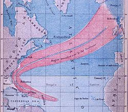 Track of Hurricane II of 1848
I. On August 18, a tropical storm hit south central Louisiana, causing damage to cotton crops.
II. A hurricane tracked northeast of the Caribbean Sea through the Bahamas and recurved through the North Atlantic shipping lanes towards Europe between August 19 and September 2.[4] This storm was one of the earliest tropical cyclones to have a track created.[5]
III. A major hurricane, the Great Gale of 1848, hit near present-day Sarasota, Florida on September 25, creating a new waterway now called New Pass, named by William Whitaker as the first person to see this new waterway. It made landfall in Tampa Bay, near Fort Brooke and Tampa, where tides rose 15 feet (4.6 m) and the barometric pressure dipped to 28.18 inches (716 mm). It crossed to the east coast where it damaged houses, caused flooding and interfered with shipping.[6]
IV. An eastward moving major hurricane hit the Florida Panhandle on October 11.
V. On October 17, a minimal hurricane hit the southeast coast of Texas, causing flooding and high tides.
1849 Atlantic hurricane season
I. A tropical cyclone may have moved into the Arklatex, as there was excessive flooding in northern sections of Louisiana that August.[7]
II. A minimal hurricane moved into the Rio Grande river area on September 13.
III. A hurricane was first detected off the coast of North Carolina in early October. It moved northeastward, passing close but remaining offshore of Long Island. On October 6, it made landfall in Massachusetts, causing 143 deaths.
See also
References
World Wide Web
- ^ a b David M. Roth (January 2010). "Louisiana Hurricane History". National Oceanic and Atmospheric Administration. p. 16. http://www.hpc.ncep.noaa.gov/research/lahur.pdf. Retrieved 2011-06-02.
- ^ Vaquero, J. M.; García-Herrera, R.; Wheeler, D.; Chenoweth, M.; Mock, C. J. (2008). "A Historical Analog of 2005 Hurricane Vince". Bulletin of the American Meteorological Society 89 (2): 191–201. Bibcode 2008BAMS...89..191V. doi:10.1175/BAMS-89-2-191.
- ^ Maritime Business Strategies, LLC. William H. Webb. Retrieved on 2007-02-18.
- ^ Michael Chenoweth. A Reassessment of Historical Atlantic Tropical Cyclone Activity: 1700-1855. Retrieved on 2007-02-18.
- ^ NOAA Photo Library. Hurricane of August and September 1848. Retrieved on 2011-01-29.
- ^ Brian H. Bossak. Chapter 2: Documents of Early American Hurricanes. Retrieved on 2007-02-03.
- ^ National Weather Service Forecast Office Shreveport, Louisiana. Historic Floods. Retrieved on 2007-02-03.
Printed media
- John Rousmaniere. After the Storm: True Stories of Disaster and Recovery at Sea. McGraw-Hill Publishing, 2002.
External links
World Wide Web
- List of Atlantic hurricane seasons
- Tampa and the Hurricane of 1848
- http://www.nhc.noaa.gov/pastdeadly.shtml
- http://www.rootsweb.com/~nchyde/HURICANE.HTM
- http://www.intellicast.com/Almanac/Southeast/October/content.shtml
- http://www.hpc.ncep.noaa.gov/research/txhur.pdf
- http://www.hpc.ncep.noaa.gov/research/lahur.pdf
- http://garnet.acns.fsu.edu/~jelsner/HHITProject/HHITyears/
Categories:- Atlantic hurricane seasons
- 1840–1849 Atlantic hurricane seasons

Wikimedia Foundation. 2010.