- National Register of Historic Places listings in West Feliciana Parish, Louisiana
-
 Location of West Feliciana Parish in Louisiana
This is a list of the National Register of Historic Places listings in West Feliciana Parish, Louisiana.
This is intended to be a complete list of the properties and districts on the National Register of Historic Places in West Feliciana Parish, Louisiana, United States. The locations of National Register properties and districts for which the latitude and longitude coordinates are included below, may be seen in a Google map.[1]
There are 30 properties and districts listed on the National Register in the parish, including 1 National Historic Landmark.
-
- This National Park Service list is complete through NPS recent listings posted November 10, 2011.[2]
Current listings
[3] Landmark name[4] Image Date listed Location City or Town Summary 1 3 V Tourist Court January 21, 1993 111 E. Commerce St.
30°46′44″N 91°22′32″W / 30.77889°N 91.37556°WSt. Francisville 2 Afton Villa Gardens February 24, 1983 North of St. Francisville on U.S. Route 61
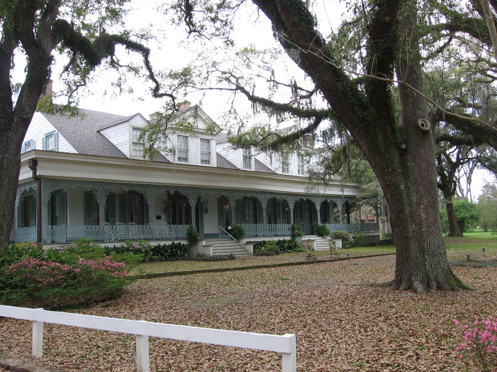
30°51′6″N 91°23′17″W / 30.85167°N 91.38806°WSt. Francisville 3 Bloodhound Site May 2, 1983 Address Restricted Angola An archaeological site once occupied by the Tunica tribe. 4 Butler-Greenwood Plantation April 17, 1979 North of St. Francisville on U.S. Route 61
30°49′11″N 91°23′23″W / 30.81972°N 91.38972°WSt. Francisville 5 Catalpa July 12, 1984 U.S. Route 61
30°51′4″N 91°22′33″W / 30.85111°N 91.37583°WSt. Francisville 6 Cottage Plantation March 17, 1975 6 miles north of St. Francisville on U.S. Route 61
30°51′11″N 91°21′37″W / 30.85306°N 91.36028°WSt. Francisville 7 Grace Episcopal Church March 28, 1979 510 Ferdinand St.
30°46′33″N 91°23′14″W / 30.77583°N 91.38722°WSt. Francisville 8 Hazelwood Plantation 
July 31, 1978 Southeast of Laurel Hill on Hazelwood Rd.
30°56′56″N 91°19′56″W / 30.94889°N 91.33222°WLaurel Hill 9 Highland August 23, 1983 Northwest of St. Francisville, off Highland Rd.
30°53′8″N 91°25′49″W / 30.88556°N 91.43028°WSt. Francisville 10 Laurel Hill June 6, 1980 Northeast of St. Francisville
30°57′41″N 91°19′33″W / 30.96139°N 91.32583°WSt. Francisville 11 Live Oak 
March 11, 1977 1.3 miles south of Weyanoke
30°56′0″N 91°27′17″W / 30.933333°N 91.45472°WWeyanoke 12 Myrtles Plantation 
September 6, 1978 U.S. Route 61
30°48′11″N 91°23′15″W / 30.80306°N 91.3875°WSt. Francisville 13 Oak Grove Plantation Dependencies February 13, 1992 U.S. Route 61, south of its junction with Louisiana Highway 421
30°52′34″N 91°21′58″W / 30.87611°N 91.36611°WSt. Francisville 14 Oakley Plantation House January 25, 1973 4.5 miles east of St. Francisville in Audubon Memorial State Park
30°47′48″N 91°18′26″W / 30.79667°N 91.30722°WSt. Francisville 15 The Oaks August 20, 1979 U.S. Route 61
30°48′34″N 91°23′12″W / 30.80944°N 91.38667°WHardwood 16 Propinquity March 26, 1973 Royal and Johnson Sts.
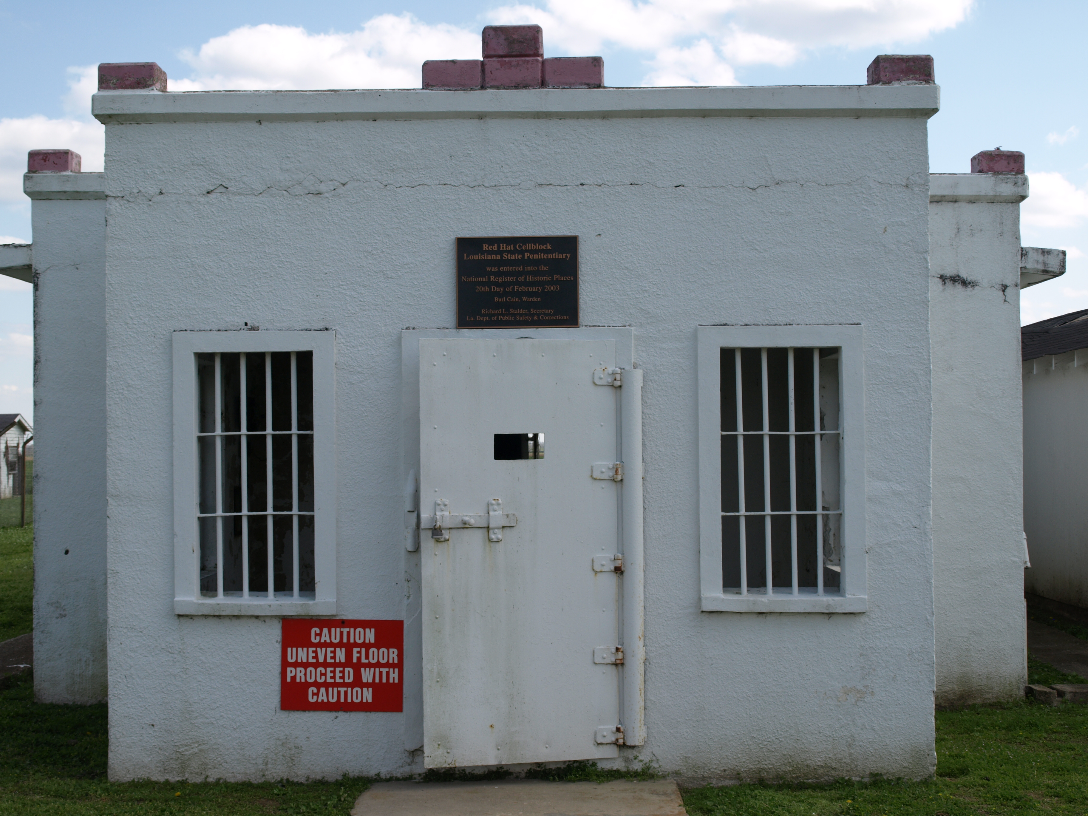
30°46′27″N 91°23′11″W / 30.77417°N 91.38639°WSt. Francisville 17 Red Hat Cell Block, Louisiana State Penitentiary 
February 20, 2003 Louisiana State Penitentiary
30°57′56″N 91°36′49″W / 30.96556°N 91.61361°WAngola 18 Rosale Plantation December 8, 1980 North of St. Francisville off U.S. Route 61
30°51′52″N 91°21′36″W / 30.86444°N 91.36°WSt. Francisville 19 Rosebank Plantation House April 13, 1973 Southeast of Weyanoke off Louisiana Highway 66
30°55′27″N 91°26′33″W / 30.92417°N 91.4425°WWeyanoke 20 Rosedown Plantation 
August 7, 2001 U.S. Route 61 and Louisiana Highway 10
30°47′58″N 91°22′23″W / 30.79944°N 91.37306°WSt. Francisville 21 St. Francisville Historic District April 2, 1980 Royal and Prosperity Sts.; also Ferdinand and Sewell Sts.
30°46′28″N 91°23′9″W / 30.77444°N 91.38583°WSt. Francisville Second set of addresses represents a boundary increase of October 1, 1982 22 St. John's Episcopal Church October 4, 1984 Old Laurel Hill Rd.
30°57′24″N 91°20′29″W / 30.95667°N 91.34139°WLaurel Hill 23 St. Mary's Episcopal Church September 29, 1980 Northwest of Weyanoke on Louisiana Highway 66
30°57′56″N 91°28′11″W / 30.96556°N 91.46972°WWeyanoke 24 Solitude Plantation House January 27, 1983 Northwest of St. Francisville on Tunica Rd.
30°49′17″N 91°25′26″W / 30.82139°N 91.42389°WSt. Francisville 25 Star Hill Plantation Dependency July 24, 2003 5018 U.S. Route 61
30°45′56″N 91°19′0″W / 30.76556°N 91.316667°WStar Hill 26 Star Hill Post Office and Store February 4, 2000 4630 U.S. Route 61
30°45′43″N 91°18′24″W / 30.76194°N 91.30667°WSt. Francisville 27 Trudeau House July 28, 1995 Junction of Louisiana Highway 66 and Old Tunica Rd.
30°56′6″N 91°32′15″W / 30.935°N 91.5375°WTunica 28 Trudeau Landing June 17, 1977 Address Restricted Tunica An archaeological site once occupied by the Tunica tribe. 29 Wakefield June 6, 1980 U.S. Route 61
30°53′18″N 91°21′14″W / 30.88833°N 91.35389°WWakefield 30 Weyanoke November 15, 1990 Sligo Rd., 5 miles north of its junction with Louisiana Highway 66
30°56′14″N 91°25′3″W / 30.93722°N 91.4175°WWeyanoke See also
- List of National Historic Landmarks in Louisiana
- National Register of Historic Places listings in Louisiana
References
- ^ The latitude and longitude information provided in this table was derived originally from the National Register Information System, which has been found to be fairly accurate for about 99% of listings. For about 1% of NRIS original coordinates, experience has shown that one or both coordinates are typos or otherwise extremely far off; some corrections may have been made. A more subtle problem causes many locations to be off by up to 150 yards, depending on location in the country: most NRIS coordinates were derived from tracing out latitude and longitudes off of USGS topographical quadrant maps created under the North American Datum of 1927, which differs from the current, highly accurate WGS84 GPS system used by Google maps. Chicago is about right, but NRIS longitudes in Washington are higher by about 4.5 seconds, and are lower by about 2.0 seconds in Maine. Latitudes differ by about 1.0 second in Florida. Some locations in this table may have been corrected to current GPS standards.
- ^ "National Register of Historic Places: Weekly List Actions". National Park Service, United States Department of the Interior. Retrieved on November 10, 2011.
- ^ Numbers represent an ordering by significant words. Various colorings, defined here, differentiate National Historic Landmark sites and National Register of Historic Places Districts from other NRHP buildings, structures, sites or objects.
- ^ "National Register Information System". National Register of Historic Places. National Park Service. 2009-03-13. http://nrhp.focus.nps.gov/natreg/docs/All_Data.html.
U.S. National Register of Historic Places Topics Lists by states Alabama • Alaska • Arizona • Arkansas • California • Colorado • Connecticut • Delaware • Florida • Georgia • Hawaii • Idaho • Illinois • Indiana • Iowa • Kansas • Kentucky • Louisiana • Maine • Maryland • Massachusetts • Michigan • Minnesota • Mississippi • Missouri • Montana • Nebraska • Nevada • New Hampshire • New Jersey • New Mexico • New York • North Carolina • North Dakota • Ohio • Oklahoma • Oregon • Pennsylvania • Rhode Island • South Carolina • South Dakota • Tennessee • Texas • Utah • Vermont • Virginia • Washington • West Virginia • Wisconsin • WyomingLists by territories Lists by associated states Other Municipalities and communities of West Feliciana Parish, Louisiana Town 
Unincorporated
communitiesCategories:- West Feliciana Parish, Louisiana
- National Register of Historic Places in Louisiana by parish
- Buildings and structures in West Feliciana Parish, Louisiana
-


Wikimedia Foundation. 2010.