- National Register of Historic Places listings in West Denver, Colorado
-
This is a list of the National Register of Historic Places listings in West Denver, Colorado.
This is intended to be a complete list of the properties and districts on the National Register of Historic Places in western Denver, Colorado, United States. West Denver is defined as being all of the city west of the Platte River. The locations of National Register properties and districts may be seen in a Google map.[1]
There are 288 properties and districts listed on the National Register in Denver. West Denver includes 43 of these properties and districts, including 2 that extend into other regions; the city's remaining properties and districts are listed elsewhere. Another property was once listed but has been removed.
-
- This National Park Service list is complete through NPS recent listings posted November 10, 2011.[2]
Current listings
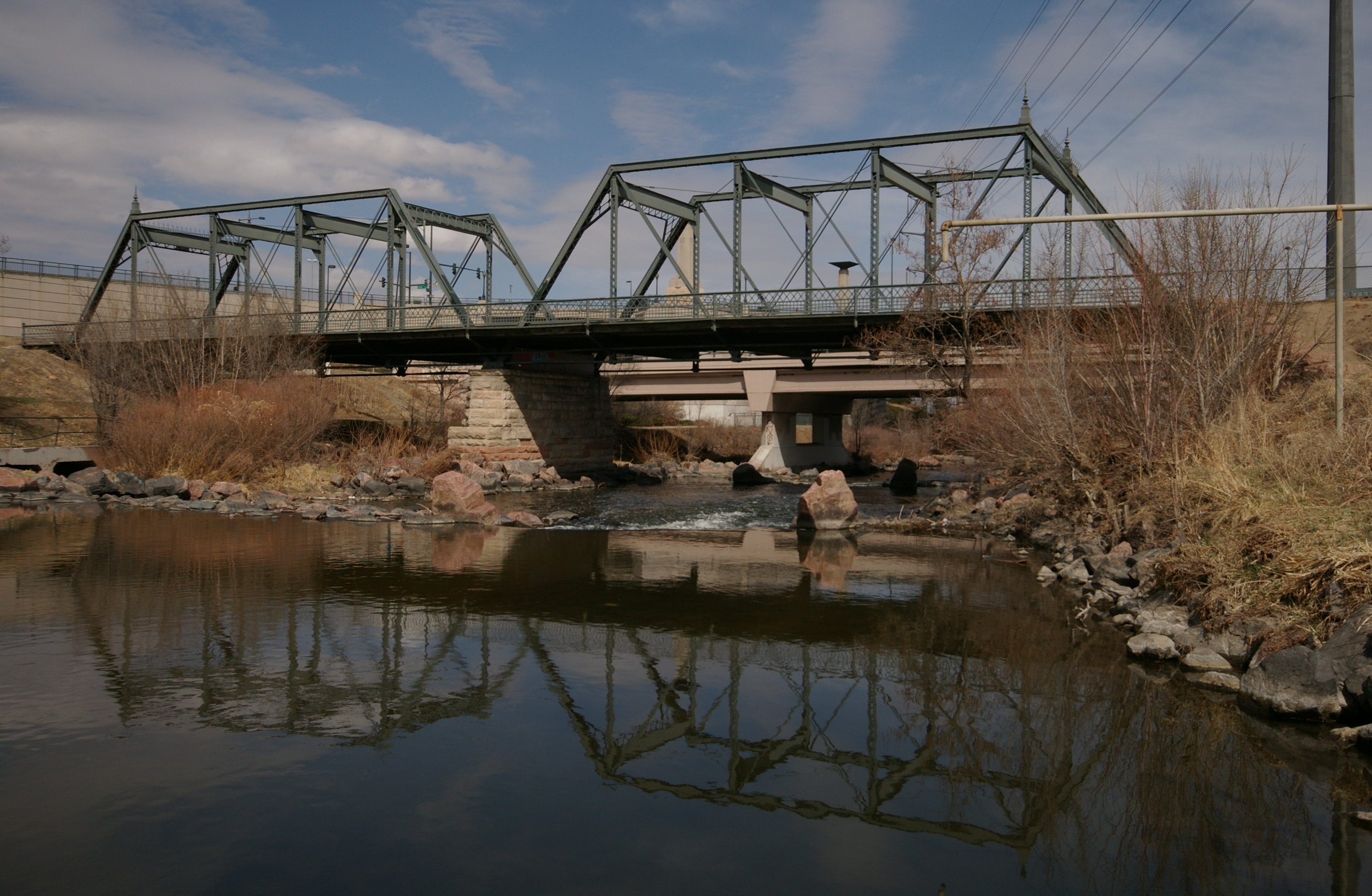
[3] Landmark name[4] Image Date listed Location Neighborhood Summary 1 19th Street Bridge 
February 4, 1985 19th St.
39°45′36″N 105°0′12″W / 39.76°N 105.00333°WHighland Extends into Union Station in Downtown Denver 2 All Saints Episcopal Church 
June 23, 1978 2222 W. 32nd Ave.
39°45′43″N 105°0′49″W / 39.76194°N 105.01361°WHighland 3 Avoca Lodge 
January 26, 1990 2690 S. Wadsworth Boulevard
39°40′5″N 105°4′50″W / 39.66806°N 105.08056°WBear Valley 4 Berkeley Lake Park 
September 17, 1986 Roughly bounded by the northern side of Berkeley Lake, Tennyson St., W. 46th Ave., and Sheridan Boulevard
39°46′56″N 105°2′52″W / 39.78222°N 105.04778°WBerkeley 5 Berkeley School 
November 1, 1996 5025-5055 Lowell Boulevard
39°47′19″N 105°2′4″W / 39.78861°N 105.03444°WRegis 6 William Norman Bowman House-Yamecila 
March 14, 1991 325 King St.
39°43′21″N 105°2′1″W / 39.7225°N 105.03361°WBarnum 7 Bryant-Webster Elementary School 
December 7, 1995 3635 Quivas St.
39°46′3″N 105°0′28″W / 39.7675°N 105.00778°WHighland 8 Building at 1389 Stuart Street 
July 19, 1982 1389 Stuart St.
39°44′17″N 105°2′33″W / 39.73806°N 105.0425°WWest Colfax 9 Building at 1390 Stuart Street 
July 19, 1982 1390 Stuart St.
39°44′17″N 105°2′32″W / 39.73806°N 105.04222°WWest Colfax 10 Building at 1435 Stuart Street 
July 19, 1982 1435 Stuart St.
39°44′22″N 105°2′33″W / 39.73944°N 105.0425°WWest Colfax 11 Building at 1444 Stuart Street 
July 19, 1982 1444 Stuart St.
39°44′23″N 105°2′32″W / 39.73972°N 105.04222°WWest Colfax 12 Building at 1471 Stuart Street 
July 19, 1982 1471 Stuart St.
39°44′23″N 105°2′33″W / 39.73972°N 105.0425°WWest Colfax 13 Denver Tramway Powerhouse 
September 8, 2001 1416 Platte St.
39°45′18″N 105°0′32″W / 39.755°N 105.00889°WHighland 14 Dickinson Branch Library 
March 28, 2002 1545 Hooker St.
39°44′29″N 105°1′41″W / 39.74139°N 105.02806°WWest Colfax 15 William J. Dunwoody House 
April 11, 1979 2637 W. 26th Ave.
39°45′18″N 105°1′11″W / 39.755°N 105.01972°WJefferson Park 16 Elitch Theatre 
March 21, 1978 W. 38th Ave. and Tennyson St.
39°46′6″N 105°2′46″W / 39.76833°N 105.04611°WWest Highland 17 Fourth Church of Christ, Scientist 
April 21, 2004 3101 W. 31st Ave.
39°45′40″N 105°1′37″W / 39.76111°N 105.02694°WWest Highland 18 Hanigan-Canino Terrace 
November 25, 1987 1421-1435 W. 35th Ave.
39°45′57″N 105°0′12″W / 39.76583°N 105.00333°WHighland 19 Highland Park 
September 17, 1986 Roughly bounded by Highland Park Pl., Federal Boulevard, and Fairview Pl.
39°45′47″N 105°1′34″W / 39.76306°N 105.02611°WWest Highland 20 Highland Park Historic District 
January 18, 1985 Bounded by Zuni St., Dunkeld Pl., Clay St., and 32nd Ave.
39°45′39″N 105°1′2″W / 39.76083°N 105.01722°WHighland 21 Highlands Masonic Lodge 
November 22, 1995 3220 Federal Boulevard
39°45′45″N 105°1′27″W / 39.7625°N 105.02417°WHighland 22 Inspiration Point 
September 17, 1986 Roughly bounded by W. 50th Ave., Sheridan Boulevard, W. 49th Ave., and Fenton St.
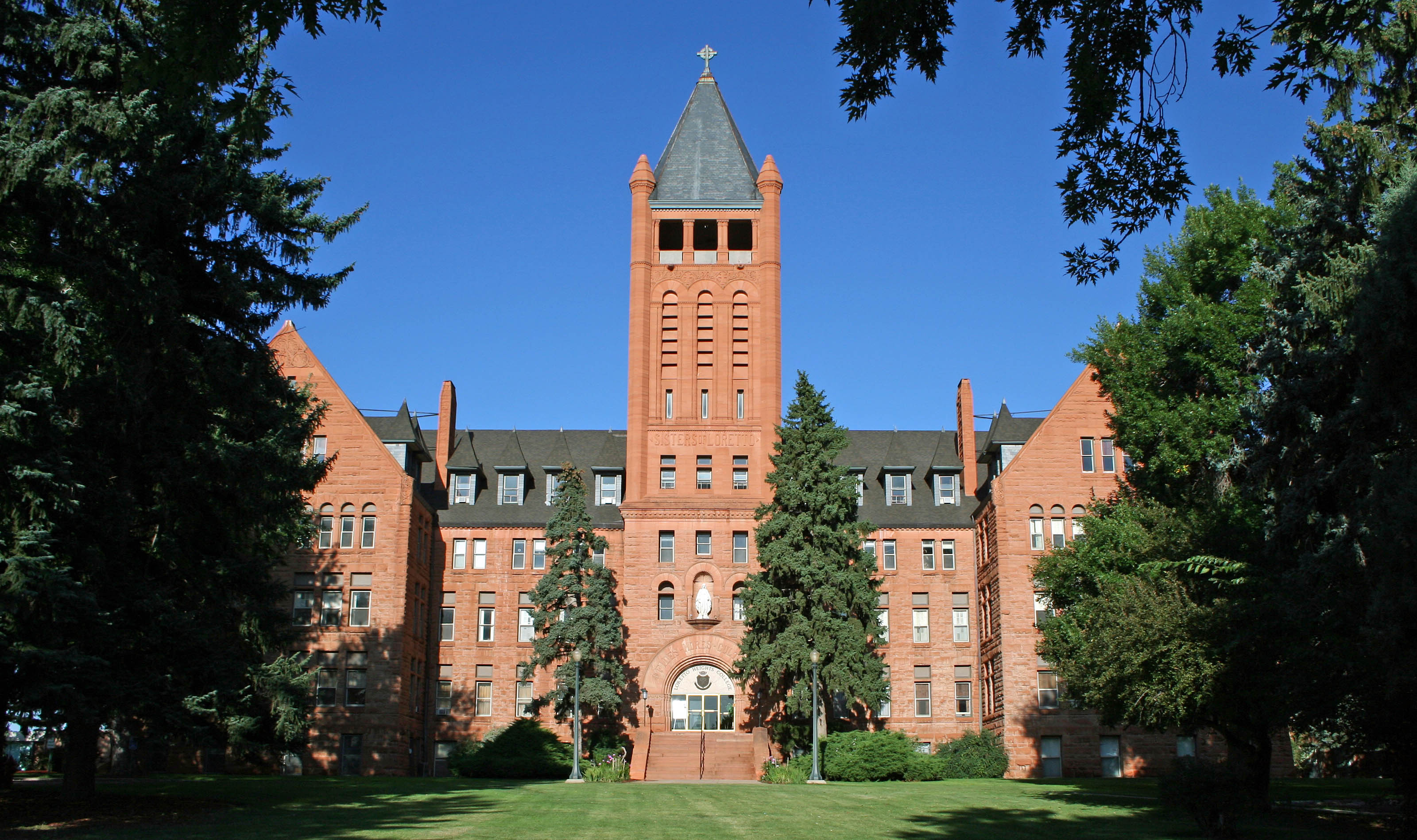
39°47′11″N 105°3′22″W / 39.78639°N 105.05611°WRegis 23 Loretto Heights Academy 
September 18, 1975 3001 S. Federal Boulevard
39°39′42″N 105°1′38″W / 39.66167°N 105.02722°WHarvey Park South 24 Frederick W. Neef House 
October 25, 1979 2143 Grove St.
39°44′59″N 105°1′35″W / 39.74972°N 105.02639°WSloan Lake 25 Niblock-Yacovetta Terrace 
June 27, 1986 1301-1319 W. 35th Ave.
39°45′57″N 105°0′12″W / 39.76583°N 105.00333°WHighland 26 Old Highland Business District 
July 17, 1979 15th and Boulder Sts.
39°45′29″N 105°0′38″W / 39.75806°N 105.01056°WHighland 27 Oriental Theater 
September 26, 1997 4329-39 W. 44th Ave.
39°46′37″N 105°2′35″W / 39.77694°N 105.04306°WBerkeley 28 Overland Cotton Mill 
April 3, 2001 1314 W. Evans Ave.
39°40′36″N 105°0′13″W / 39.67667°N 105.00361°WCollege View and South Platte 29 Potter Highlands Historic District 
January 22, 1986 Roughly bounded by W. 38th, Zuni, and W. 32nd Sts., and Federal Boulevard
39°45′53″N 105°1′9″W / 39.76472°N 105.01917°WHighland 30 Rocky Mountain Hotel 
April 21, 1983 2301 7th St.
39°45′8″N 105°0′51″W / 39.75222°N 105.01417°WJefferson Park 31 Rocky Mountain Lake Park 
September 17, 1986 Roughly bounded by Interstate 70, Federal Boulevard, W. 46th Ave., and Lowell Boulevard
39°46′55″N 105°1′47″W / 39.78194°N 105.02972°WBerkeley 32 Romeo Block 
January 4, 1996 2944 Zuni St.
39°45′33″N 105°0′54″W / 39.75917°N 105.015°WHighland 33 Amos H. Root Building 
March 27, 1980 1501-1529 Platte St.
39°45′24″N 105°0′32″W / 39.75667°N 105.00889°WHighland 34 St. Dominic's Church 
November 1, 1996 3005 W. 29th Ave.
39°45′32″N 105°1′31″W / 39.75889°N 105.02528°WWest Highland 35 St. Elizabeth's Retreat Chapel 
May 24, 1976 2825 W. 32nd Ave.
39°45′46″N 105°1′19″W / 39.76278°N 105.02194°WHighland 36 St. Joseph's Polish Roman Catholic Church 
April 21, 1983 517 E. 46th Ave.
39°46′49″N 104°58′54″W / 39.78028°N 104.98167°WGlobeville 37 St. Patrick Mission Church 
November 14, 1979 3325 Pecos St.
39°45′49″N 105°0′23″W / 39.76361°N 105.00639°WHighland 38 George Schmidt House 
October 29, 1976 2345 7th St.
39°45′10″N 105°0′52″W / 39.75278°N 105.01444°WJefferson Park 39 South Platte River Bridges 
October 15, 2002 Interstate 25 at milepost 210.53
39°44′36″N 105°0′56″W / 39.74333°N 105.01556°WJefferson Park and Sun Valley Extends into Auraria in Northeast Denver 40 Stonemen's Row Historic District 
January 5, 1984 Southern side of 28th Ave. between Umatilla and Vallejo Sts.
39°45′26″N 105°0′43″W / 39.75722°N 105.01194°WHighland 41 Tallmadge and Boyer Block 
October 21, 1982 2926-2942 Zuni St.
39°45′32″N 105°0′54″W / 39.75889°N 105.015°WHighland 42 Tilden School for Teaching Health 
September 7, 1995 Junction of W. Fairview Pl. and Grove St.
39°45′51″N 105°1′41″W / 39.76417°N 105.02806°WWest Highland 43 West Forty-sixth Avenue Parkway 
September 17, 1986 W. 46th Ave. Parkway from Stuart St. to Grove St.
39°46′49″N 105°1′33″W / 39.78028°N 105.02583°WBerkeley Former listing
Landmark name Image Date removed Location City or Town Summary 1 Wheeler House 
January 14, 2010 1917 W. 32nd Ave.
39°45′44″N 105°0′34″W / 39.76222°N 105.00944°WHighland Listed March 1, 2000 See also
- List of National Historic Landmarks in Colorado
- National Register of Historic Places listings in Denver, Colorado
References
- ^ The latitude and longitude information provided in this table was derived originally from the National Register Information System, which has been found to be fairly accurate for about 99% of listings. For about 1% of NRIS original coordinates, experience has shown that one or both coordinates are typos or otherwise extremely far off; some corrections may have been made. A more subtle problem causes many locations to be off by up to 150 yards, depending on location in the country: most NRIS coordinates were derived from tracing out latitude and longitudes off of USGS topographical quadrant maps created under North American Datum of 1927, which differs from the current, highly accurate GPS system used by Google maps. Chicago is about right, but NRIS longitudes in Washington are higher by about 4.5 seconds, and are lower by about 2.0 seconds in Maine. Latitudes differ by about 1.0 second in Florida. Some locations in this table may have been corrected to current GPS standards.
- ^ "National Register of Historic Places: Weekly List Actions". National Park Service, United States Department of the Interior. Retrieved on November 10, 2011.
- ^ Numbers represent an ordering by significant words. Various colorings, defined here, differentiate National Historic Landmark sites and National Register of Historic Places Districts from other NRHP buildings, structures, sites or objects.
- ^ "National Register Information System". National Register of Historic Places. National Park Service. 2008-04-24. http://nrhp.focus.nps.gov/natreg/docs/All_Data.html.
Categories:- Buildings and structures in Denver, Colorado
- National Register of Historic Places in Denver, Colorado
-


Wikimedia Foundation. 2010.