- National Register of Historic Places listings in Saunders County, Nebraska
-
 Location of Saunders County in Nebraska
This is a list of the National Register of Historic Places listings in Saunders County, Nebraska. It is intended to be a complete list of the properties and districts on the National Register of Historic Places in Saunders County, Nebraska, United States. The locations of National Register properties and districts for which the latitude and longitude coordinates are included below, may be seen in a Google map.[1]
There are 19 properties and districts listed on the National Register in the county.
-
- This National Park Service list is complete through NPS recent listings posted November 10, 2011.[2]
Listings county-wide
[3] Landmark name Image Date listed Location City or town Summary 1 Ashland Archeological District November 29, 2000 Address Restricted Ashland 2 Ashland Bridge 
June 29, 1992 Silver St. over Salt Creek
41°02′04″N 96°22′01″W / 41.034444°N 96.366944°WAshland 3 Ashland Public Library 
January 27, 1983 207 N. 15th St.
41°02′27″N 96°22′08″W / 41.040833°N 96.368889°WAshland 4 Barnes Oil Company 
December 5, 2002 Junction of Silver St. and U.S. Route 6
41°02′20″N 96°21′26″W / 41.038889°N 96.357222°WAshland 5 Israel Beetison House 
April 18, 1977 Southeast of Ashland
41°01′54″N 96°21′12″W / 41.031667°N 96.353333°WAshland 6 Howard Hanson House 
January 27, 1983 12th and Linden Sts.
41°12′59″N 96°37′07″W / 41.216389°N 96.618611°WWahoo 7 Old Ithaca Grain Elevator 
February 23, 2001 One block south of 4th St.
41°09′27″N 96°32′19″W / 41.1575°N 96.538611°WIthaca 8 F.J. Kirchman House 
August 21, 2003 957 Beech St.
41°12′52″N 96°37′02″W / 41.214444°N 96.617222°WWahoo 9 Leshara Site March 16, 1972 Address Restricted Leshara 10 McClean Site March 16, 1972 Address Restricted Inglewood 11 National Bank of Ashland 
January 27, 1983 1442 Silver St.
41°02′21″N 96°22′09″W / 41.039167°N 96.369167°WAshland 12 O.K. Market 
July 3, 1991 542 N. Linden Ave.
41°12′38″N 96°36′23″W / 41.210556°N 96.606389°WWahoo 13 Pahuk August 14, 1973 Address Restricted Cedar Bluffs 14 Rad Plzen cis. 9 Z.C.B.J. (SD10-6) 
March 20, 1986 Off Nebraska Highway 79
41°25′52″N 96°45′58″W / 41.431111°N 96.766111°WMorse Bluff 15 St. Stephen's Episcopal Church 
January 25, 1979 16th and Adams Sts.[4]
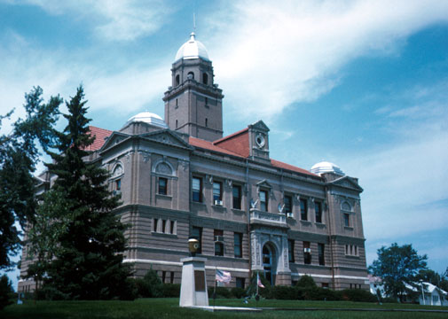
41°02′25″N 96°22′16″W / 41.040278°N 96.371111°WAshland 16 Saunders County Courthouse 
January 10, 1990 Chestnut between 4th and 5th Sts.
41°12′42″N 96°43′49″W / 41.211667°N 96.730278°WWahoo 17 Wahoo Burlington Depot 
May 9, 1985 431 W. 3rd
41°12′27″N 96°36′44″W / 41.2075°N 96.612222°WWahoo 18 Woodcliff Burials March 7, 1973 Address Restricted Inglewood 19 Yutan Site June 26, 1972 Address Restricted Yutan See also
- List of National Historic Landmarks in Nebraska
- National Register of Historic Places listings in Nebraska
References
- ^ The latitude and longitude information provided in this table was derived originally from the National Register Information System, which has been found to be fairly accurate for about 99% of listings. For about 1% of NRIS original coordinates, experience has shown that one or both coordinates are typos or otherwise extremely far off; some corrections may have been made. A more subtle problem causes many locations to be off by up to 150 yards, depending on location in the country: most NRIS coordinates were derived from tracing out latitude and longitudes off of USGS topographical quadrant maps created under North American Datum of 1927, which differs from the current, highly accurate GPS system used by Google maps. Chicago is about right, but NRIS longitudes in Washington are higher by about 4.5 seconds, and are lower by about 2.0 seconds in Maine. Latitudes differ by about 1.0 second in Florida. Some locations in this table may have been corrected to current GPS standards.
- ^ "National Register of Historic Places: Weekly List Actions". National Park Service, United States Department of the Interior. Retrieved on November 10, 2011.
- ^ Numbers represent an ordering by significant words. Various colorings, defined here, differentiate National Historic Landmark sites and National Register of Historic Places Districts from other NRHP buildings, structures, sites or objects.
- ^ See photo.
U.S. National Register of Historic Places Topics Lists by states Alabama • Alaska • Arizona • Arkansas • California • Colorado • Connecticut • Delaware • Florida • Georgia • Hawaii • Idaho • Illinois • Indiana • Iowa • Kansas • Kentucky • Louisiana • Maine • Maryland • Massachusetts • Michigan • Minnesota • Mississippi • Missouri • Montana • Nebraska • Nevada • New Hampshire • New Jersey • New Mexico • New York • North Carolina • North Dakota • Ohio • Oklahoma • Oregon • Pennsylvania • Rhode Island • South Carolina • South Dakota • Tennessee • Texas • Utah • Vermont • Virginia • Washington • West Virginia • Wisconsin • WyomingLists by territories Lists by associated states Other  Category:National Register of Historic Places •
  Portal:National Register of Historic Places
Municipalities and communities of Saunders County, Nebraska County seat: Wahoo Cities 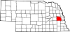
Villages Cedar Bluffs | Ceresco | Colon | Ithaca | Leshara | Malmo | Mead | Memphis | Morse Bluff | Prague | Valparaiso | Weston
Townships Ashland | Bohemia | Center | Chapman | Chester | Clear Creek | Douglas | Elk | Green | Leshara | Marble | Marietta | Mariposa | Morse Bluff | Newman | North Cedar | Oak Creek | Pohocco | Richland | Rock Creek | South Cedar | Stocking | Union | Wahoo
Categories:- National Register of Historic Places in Nebraska by county
- Saunders County, Nebraska
- Buildings and structures in Saunders County, Nebraska
-


Wikimedia Foundation. 2010.