- National Register of Historic Places listings in Powhatan County, Virginia
-
This list includes properties and districts listed on the National Register of Historic Places in Powhatan County, Virginia. Click the "Map of all coordinates" link to the right to view a Google map of all properties and districts with latitude and longitude coordinates in the table below.[1]
-
- This National Park Service list is complete through NPS recent listings posted November 10, 2011.[2]
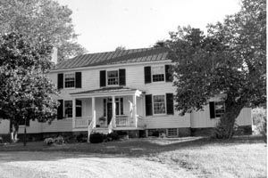
[3] Landmark name[4] Image Date listed Location City or Town Summary 1 Beaumont April 2, 1987 VA 313
37°40′4″N 77°54′46″W / 37.66778°N 77.91278°WMichaux 2 Belmead November 12, 1969 NW of jct. of Rtes. 663 and 600
37°37′24″N 77°58′45″W / 37.62333°N 77.97917°WPowhatan 3 Belnemus 
April 20, 1979 W of Powhatan off U.S. 60
37°34′3″N 77°59′48″W / 37.5675°N 77.99667°WPowhatan 4 Blenheim December 11, 1986 6177 Blenheim Rd.
37°30′49″N 78°5′4″W / 37.51361°N 78.08444°WBallsville 5 Elmington January 20, 2005 3277 Maidens Rd.
37°36′30″N 77°55′45″W / 37.60833°N 77.92917°WPowhatan 6 Emmanuel Episcopal Church December 27, 1990 Emmanuel Church Rd. S of US 60
37°33′36″N 77°57′17″W / 37.56°N 77.95472°WPowhatan 7 Fine Creek Mills Historic District January 16, 2004 2425-2434 Robert E. Lee Rd. (VA 641)
37°36′1″N 77°49′5″W / 37.60028°N 77.81806°WFine Creek Mills 8 French's Tavern April 21, 1989 6100 Old Buckingham Rd.
37°29′34″N 78°4′58″W / 37.49278°N 78.08278°WBallsville 9 Huguenot Memorial Chapel and Monument March 23, 1988 VA 711
37°33′53″N 77°42′33″W / 37.56472°N 77.70917°WManakin 10 Keswick 
December 19, 1974 NE of Powhatan off VA 711
37°33′39″N 77°39′52″W / 37.56083°N 77.66444°WPowhatan 11 Mosby Tavern 
April 11, 2003 2625 Old Tavern Rd.
37°33′53″N 78°2′16″W / 37.56472°N 78.03778°WPowhatan 12 Norwood 
May 19, 1980 NE of Powhatan
37°35′5″N 77°44′38″W / 37.58472°N 77.74389°WPowhatan 13 Paxton December 28, 1990 3032 Genito Rd.
37°27′47″N 77°51′36″W / 37.46306°N 77.86°WPowhatan 14 Powhatan Courthouse Historic District 
February 16, 1970 Jct. of Rtes. 13 and 300
37°32′29″N 77°55′9″W / 37.54139°N 77.91917°WPowhatan 15 Provost December 22, 1999 4801 Cartersville Rd.
37°36′3″N 77°59′2″W / 37.60083°N 77.98389°WPowhatan 16 Red Lane Tavern January 24, 2002 3009 Lower Hill Rd.
37°31′46″N 77°51′29″W / 37.52944°N 77.85806°WPowhatan 17 Rosemont May 29, 2008 4747 Cosby Rd.
37°36′21.63″N 77°58′42.16″W / 37.6060083°N 77.9783778°WPowhatan 18 Somerset September 6, 2006 2310 Ballsville Rd.
37°32′59″N 78°5′17″W / 37.54972°N 78.08806°WPowhatan 19 St. Luke's Episcopal Church March 29, 1989 2245 Huguenot Trail
37°35′39″N 77°48′3″W / 37.59417°N 77.80083°WFine Creek Mills See also
- National Register of Historic Places listings in Virginia
- List of National Historic Landmarks in Virginia
References
- ^ The latitude and longitude information provided in this table was derived originally from the National Register Information System, which has been found to be fairly accurate for about 99% of listings. For about 1% of NRIS original coordinates, experience has shown that one or both coordinates are typos or otherwise extremely far off; some corrections may have been made. A more subtle problem causes many locations to be off by up to 150 yards, depending on location in the country: most NRIS coordinates were derived from tracing out latitude and longitudes off of USGS topographical quadrant maps created under the North American Datum of 1927, which differs from the current, highly accurate WGS84 GPS system used by Google maps. Chicago is about right, but NRIS longitudes in Washington are higher by about 4.5 seconds, and are lower by about 2.0 seconds in Maine. Latitudes differ by about 1.0 second in Florida. Some locations in this table may have been corrected to current GPS standards.
- ^ "National Register of Historic Places: Weekly List Actions". National Park Service, United States Department of the Interior. Retrieved on November 10, 2011.
- ^ Numbers represent an ordering by significant words. Various colorings, defined here, differentiate National Historic Landmark sites and National Register of Historic Places Districts from other NRHP buildings, structures, sites or objects.
- ^ "National Register Information System". National Register of Historic Places. National Park Service. 2008-04-24. http://nrhp.focus.nps.gov/natreg/docs/All_Data.html.
U.S. National Register of Historic Places Topics Lists by states Alabama • Alaska • Arizona • Arkansas • California • Colorado • Connecticut • Delaware • Florida • Georgia • Hawaii • Idaho • Illinois • Indiana • Iowa • Kansas • Kentucky • Louisiana • Maine • Maryland • Massachusetts • Michigan • Minnesota • Mississippi • Missouri • Montana • Nebraska • Nevada • New Hampshire • New Jersey • New Mexico • New York • North Carolina • North Dakota • Ohio • Oklahoma • Oregon • Pennsylvania • Rhode Island • South Carolina • South Dakota • Tennessee • Texas • Utah • Vermont • Virginia • Washington • West Virginia • Wisconsin • WyomingLists by territories Lists by associated states Other Municipalities and communities of Powhatan County, Virginia Unincorporated
communitiesBallsville | Beaumont | Belona | Chestnut Oaks | Clayville | Dorset | Fine Creek Mills | Flat Rock | Genito | Goode Crossing | Hatchers | Hideaway Lake | Holly Hills | Huguenot | Huguenot Springs | Jefferson | Lilburn | Macon | Michaux | Moseley | Pilkinton | Plain View | Powhatan | Provost | Red Lane | Smiths Crossroads | Subletts | Tobaccoville | Trenholm | Worshams
 Categories:
- Powhatan County, Virginia
- National Register of Historic Places in Virginia
- Virginia-related lists
-


Wikimedia Foundation. 2010.