- National Register of Historic Places listings in Isle of Wight County, Virginia
-
This list includes properties and districts listed on the National Register of Historic Places in Isle of Wight County, Virginia. Click the "Map of all coordinates" link to the right to view a Google map of all properties and districts with latitude and longitude coordinates in the table below.[1]
-
- This National Park Service list is complete through NPS recent listings posted November 10, 2011.[2]
[3] Landmark name [4] Image Date listed Location City or town Summary 1 Basses Choice-Days Point Archeological District July 28, 1983 Address Restricted Rushmere 2 Boykin's Tavern June 19, 1974 W of U.S. 258
36°54′27″N 76°42′34″W / 36.9075°N 76.709444°WIsle of Wight 3 Fort Boykin Archaeological Site (44IW20) August 1, 1985 Address Restricted Smithfield 4 Fort Huger April 16, 2008 Talcott Terrace Smithfield 5 Four Square July 26, 1979 W. of Smithfield on VA 620
36°57′54″N 76°41′30″W / 36.965°N 76.691667°WSmithfield 6 P. D. Gwaltney, Jr., House 
January 27, 1999 304 Church St.
36°58′53″N 76°37′42″W / 36.981389°N 76.628333°WSmithfield 7 Ivy Hill Cemetery April 4, 2007 W of N. Church St. Smithfield 8 Joseph Jordan House June 22, 1979 NE of Raynor on VA 683
36°58′16″N 76°45′45″W / 36.971111°N 76.7625°WRaynor 9 Oak Crest January 21, 1999 34457 Lee's Mill Rd.
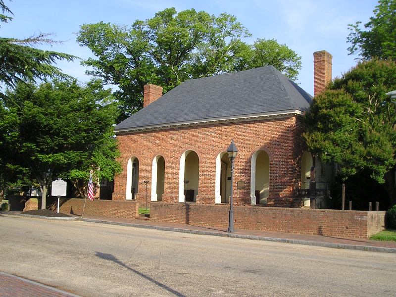
36°40′16″N 76°53′06″W / 36.671111°N 76.885°WFranklin 10 Old Isle of Wight Courthouse 
September 15, 1970 NE corner of Main and Mason Sts.
36°58′54″N 76°37′56″W / 36.981667°N 76.632222°WSmithfield 11 Col. Josiah Parker Family Cemetery April 27, 2004 Approx. 50 yds from jct. of Old Machlesfield Rd. and Macklesfield Ct.
36°58′33″N 76°32′10″W / 36.975833°N 76.536111°WSmithfield 12 Poplar Hill August 18, 1995 7968 Purvis Ln. (VA 673), 0.9 mi. NW of jct. with VA 677
37°02′05″N 76°40′54″W / 37.034722°N 76.681667°WSmithfield 13 William Rand Tavern 
May 27, 2004 112 W. Main St.
36°58′55″N 76°37′56″W / 36.981944°N 76.632222°WSmithfield 14 Henry Saunders House May 19, 2004 13009 East Windsor Blvd.
36°48′16″N 76°42′28″W / 36.804444°N 76.707778°WWindsor 15 William Scott Farmstead January 25, 1991 VA 603 E of jct. with VA 600
36°48′49″N 76°42′29″W / 36.813611°N 76.708056°WWindsor 16 Smithfield Historic District 
July 2, 1973 Roughly bounded by Pagan River, Little Creek, and town line
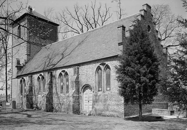
36°58′53″N 76°37′56″W / 36.981389°N 76.632222°WSmithfield 17 St. Luke's Church 
October 15, 1966 4 miles south of Smithfield on VA 10
36°56′24″N 76°35′11″W / 36.94°N 76.586389°WSmithfield Built in 1632; the oldest surviving brick church in the original thirteen U.S. states; the oldest existing church of English foundation in America. 18 Robert Tynes House March 21, 2007 13060 Courthouse Highway
36°57′54″N 76°39′47″W / 36.965°N 76.663056°WSmithfield 19 Windsor Castle Farm 
August 2, 2000 301 Jericho Rd.
36°58′32″N 76°37′35″W / 36.975556°N 76.626389°WSmithfield 20 Wolftrap Farm October 15, 1974 NW of Smithfield off VA 627
36°59′52″N 76°41′50″W / 36.997778°N 76.697222°WSmithfield Dismantled.[5] See also
- National Register of Historic Places listings in Virginia
- National Register of Historic Places listings in Franklin, Virginia
- List of National Historic Landmarks in Virginia
References
- ^ The latitude and longitude information provided in this table was derived originally from the National Register Information System, which has been found to be fairly accurate for about 99% of listings. For about 1% of NRIS original coordinates, experience has shown that one or both coordinates are typos or otherwise extremely far off; some corrections may have been made. A more subtle problem causes many locations to be off by up to 150 yards, depending on location in the country: most NRIS coordinates were derived from tracing out latitude and longitudes off of USGS topographical quadrant maps created under North American Datum of 1927, which differs from the current, highly accurate GPS system used by Google maps. Chicago is about right, but NRIS longitudes in Washington are higher by about 4.5 seconds, and are lower by about 2.0 seconds in Maine. Latitudes differ by about 1.0 second in Florida. Some locations in this table may have been corrected to current GPS standards.
- ^ "National Register of Historic Places: Weekly List Actions". National Park Service, United States Department of the Interior. Retrieved on November 10, 2011.
- ^ Numbers represent an ordering by significant words. Various colorings, defined here, differentiate National Historic Landmark sites and National Register of Historic Places Districts from other NRHP buildings, structures, sites or objects.
- ^ "National Register Information System". National Register of Historic Places. National Park Service. . http://nrhp.focus.nps.gov/natreg/docs/All_Data.html.
- ^ http://www.smithfieldtimes.com/index.php?option=com_content&view=article&id=62:wolftrap&catid=25:top-stories&Itemid=28
U.S. National Register of Historic Places Topics Lists by states Alabama • Alaska • Arizona • Arkansas • California • Colorado • Connecticut • Delaware • Florida • Georgia • Hawaii • Idaho • Illinois • Indiana • Iowa • Kansas • Kentucky • Louisiana • Maine • Maryland • Massachusetts • Michigan • Minnesota • Mississippi • Missouri • Montana • Nebraska • Nevada • New Hampshire • New Jersey • New Mexico • New York • North Carolina • North Dakota • Ohio • Oklahoma • Oregon • Pennsylvania • Rhode Island • South Carolina • South Dakota • Tennessee • Texas • Utah • Vermont • Virginia • Washington • West Virginia • Wisconsin • WyomingLists by territories Lists by associated states Other Municipalities and communities of Isle of Wight County, Virginia Towns 
CDPs Benns Church | Camptown | Carrollton | Carrsville | Rushmere
Unincorporated
communitiesBartlett | Isle of Wight | Walters | Zuni
Categories:- Isle of Wight County, Virginia
- National Register of Historic Places in Virginia
- Virginia-related lists
-


Wikimedia Foundation. 2010.