- National Register of Historic Places listings in Isle Royale National Park
-
This is a list of the National Register of Historic Places listings in Isle Royale National Park.
This is intended to be a complete list of the properties and districts on the National Register of Historic Places in Isle Royale National Park, Michigan, United States. The locations of National Register properties and districts for which the latitude and longitude coordinates are included below, may be seen in a Google map.[1]
There are 14 properties and districts listed on the National Register in the park.
-
- This National Park Service list is complete through NPS recent listings posted November 10, 2011.[2]
Current listings
[3] Landmark name[4] Image Date listed Location City or Town Summary 1 ALGOMA 
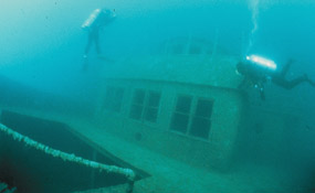
June 14, 1984 Southeast shore of Mott Island
48°6′41″N 88°31′55″W / 48.11139°N 88.53194°W[5]Isle Royale National Park The Algoma was a passenger steamer built in 1883. In November 1885, it ran into a blinding snowstorm, veered off course, and ran aground near Isle Royale. As the storm continued to rage, the ship came apart, eventually killing 46 people. The wreck of the Algoma was the worst loss of life in the history of Lake Superior shipping. 2 AMERICA 
June 14, 1984 North Gap of Washington Harbor
47°53′39″N 89°13′15″W / 47.89417°N 89.22083°W[5]Isle Royale National Park The America served as a communications link for the communities of western Lake Superior in the early 20th century. Beginning in 1902, she ran three voyages per week among Duluth, Minnesota, Isle Royale, and Thunder Bay, Ontario, as well as numerous small communities in between. In June 1928, the America ran aground while leaving Washington Harbor, and efforts to salvage her were unsuccessful. The ship can be seen from the surface, with her bow in only two feet of water. 3 CHESTER A. CONGDON 
June 14, 1984 Congdon Shoals on northeast end of Isle Royale
48°11′36″N 88°30′52″W / 48.19333°N 88.51444°W[5]Isle Royale National Park Originally named the Salt Lake City, when constructed in 1907, the bulk steel freighter sank near Isle Royale in Lake Superior in 1918. It was the first wreck in Lake Superior to be valued at over one million dollars. 4 CUMBERLAND 
June 14, 1984 Near Rock of Ages Light
47°51′28″N 89°19′32″W / 47.85778°N 89.32556°W[5]Isle Royale National Park The Cumberland was a wooden-hulled side paddlewheeler built in 1871. In July 1877, she began taking on water after leaving Thunder Bay, and struck a reef near the Rock of Ages Light. The day was clear and dry, and passengers and crew were removed without difficulty. The wreckage of the Cumberland is intermingled with some portions of the hull of the Henry Chisholm, which sank later in 1898. 5 Edisen Fishery 
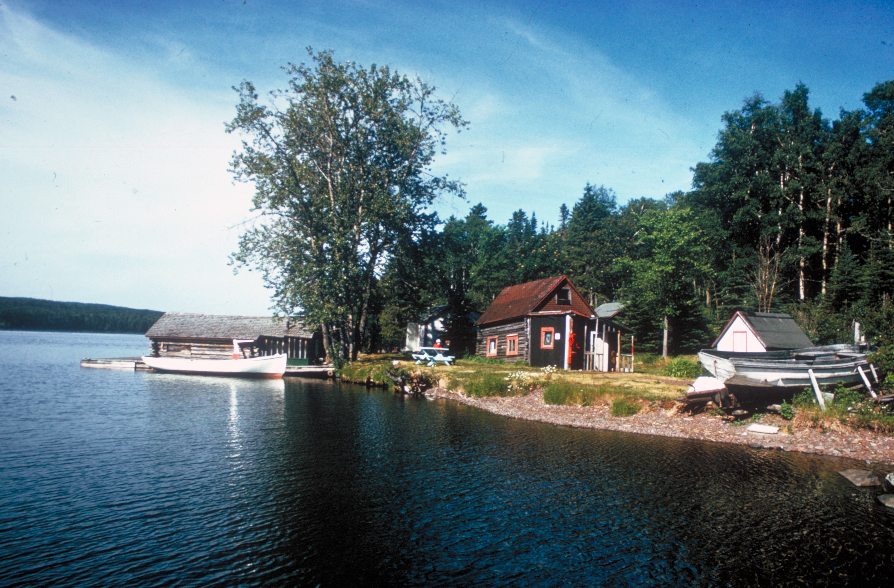
March 8, 1977 Rock Harbor
48°5′22″N 88°34′57″W / 48.08944°N 88.5825°WIsle Royale National Park The Edisen Fishery is a collection of seven buildings making up a commercial fishery, constructed between 1895 and 1934 by local fishermen using easily available local materials and built using strictly functional designs. 6 EMPEROR 
June 14, 1984 North side of Canoe Rocks, on the northeast end of Isle Royale
48°12′2″N 88°29′30″W / 48.20056°N 88.49167°W[5]Isle Royale National Park The Emperor was a freighter constructed in 1910, and at 525 feet in length, it was the largest Canadian-built freighter ever built at the time of her launching. In June 1947, the Emperor left Thunder Bay, laden with 10,429 tons of iron ore. Her course was miscalculated, and the ship ran aground at 4:15 in the morning on the north side of Canoe Rocks. The Emperor sank within 30 minutes, killing twelve crewmembers. 7 GEORGE M. COX 
June 14, 1984 Near Rock of Ages Light
47°51′28″N 89°19′32″W / 47.85778°N 89.32556°W[5]Isle Royale National Park The Cox was launched in 1901 as the USS Puritan, a civilian transport ship. It was used by the US Navy in World War I, but returned to civilian service afterward. It sank in 1933 near the Rock of Ages Light off Isle Royale in Lake Superior. 8 GLENLYON 
June 14, 1984 Glenlyon Shoals off Menagerie Island in Siskiwit Bay
47°57′8″N 88°44′53″W / 47.95222°N 88.74806°W[5]Isle Royale National Park The Glenlyon was a freighter built in 1893. Over its career, it was owned by many companies, and hauled both package freight and bulk cargo, as well as, for a short time, passengers for both U.S. and Canada. The ship ran aground on November 1, 1924, while heading for shelter in Siskiwit Bay. 9 HENRY CHISHOLM 
June 14, 1984 Near Rock of Ages Light
47°51′28″N 89°19′32″W / 47.85778°N 89.32556°W[5]Isle Royale National Park The Henry Chisholm was a wooden freighter built in 1880, and was the largest wooden "steam barge" ever built in Cleveland, approaching the practical size limit for a wooden vessel of its type. In October 1898, the Chisholm left Duluth, Minnesota, towing the 220-foot schooner John Martin. A storm blew up and the Martin was cast off. After the gale lessened, the Chisholm spent the next few days searching for the Martin, and struck a reef near the Rock of Ages Light while attempting to enter Washington Harbor. Portions of the Chisholm's hull are intermingled with the wreckage of the SS Cumberland, which had sunk earlier in 1877. 10 Johns Hotel 
August 8, 1997 Washington Harbor, on Barnum Island
47°52′43″N 89°13′58″W / 47.87861°N 89.23278°WIsle Royale National Park The Johns Hotel was established in 1892, and was the first summer resort on Isle Royale. There were once 16 buildings on the site, of which two, the main hotel and one cabin, remain. 11 KAMLOOPS 
June 14, 1984 Kamloops Point
48°5′6″N 88°45′53″W / 48.085°N 88.76472°W[5]Isle Royale National Park The SS Kamloops was a lake freighter that was part of the fleet of Canada Steamship Lines from its launching in 1924 until it sank with all hands off Isle Royale in Lake Superior on or about 7 December 1927. 12 Minong Mine Historic District 
November 11, 1977 West of McCargoe Cove campground
48°4′58″N 88°43′35″W / 48.08278°N 88.72639°W[6]Isle Royale National Park The Minong Mine site contains prehistoric copper mining pits, thought to be as old as 4500 years. In addition, the site contains the remains of the Minong Mine, a 19th century copper mine that produced 249 tons of copper over its ten years of existence. 13 MONARCH 
June 14, 1984 Palisade area on the north side of Blake Point
48°11′20″N 88°26′3″W / 48.18889°N 88.43417°W[5]Isle Royale National Park The Monarch was a passenger-package freighter built in 1890. In December 1906, the departed Thunder Bay for Sarnia in a blinding snowstorm. For some reason, the ship headed off its planned course, and that night it rammed at full speed into the palisade area on the north side of Blake Point on Isle Royale. Miraculously, all but one of the crew and passengers were able to make it to shore. 14 Rock Harbor Lighthouse 
March 8, 1977 Rock Harbor
48°5′21″N 88°34′45″W / 48.08917°N 88.57917°WIsle Royale National Park The Rock Harbor Lighthouse is located in Rock Harbor on Isle Royale in Lake Superior. It was built in 1855/56, but permanently extinguished in 1879. See also
- National Register of Historic Places listings in Keweenaw County, Michigan
- National Register of Historic Places listings in Michigan
References
- Carrell, Toni. National Register of Historic Places Inventory - Nomination Form: Shipwrecks of Isle Royale National Park. National Park Service 1983 [1]
- ^ The latitude and longitude information provided in this table was derived originally from the National Register Information System, which has been found to be fairly accurate for about 99% of listings. For about 1% of NRIS original coordinates, experience has shown that one or both coordinates are typos or otherwise extremely far off; some corrections may have been made. A more subtle problem causes many locations to be off by up to 150 yards, depending on location in the country: most NRIS coordinates were derived from tracing out latitude and longitudes off of USGS topographical quadrant maps created under the North American Datum of 1927, which differs from the current, highly accurate WGS84 GPS system used by Google maps. Chicago is about right, but NRIS longitudes in Washington are higher by about 4.5 seconds, and are lower by about 2.0 seconds in Maine. Latitudes differ by about 1.0 second in Florida. Some locations in this table may have been corrected to current GPS standards.
- ^ "National Register of Historic Places: Weekly List Actions". National Park Service, United States Department of the Interior. Retrieved on November 10, 2011.
- ^ Numbers represent an ordering by significant words. Various colorings, defined here, differentiate National Historic Landmark sites and National Register of Historic Places Districts from other NRHP buildings, structures, sites or objects.
- ^ "National Register Information System". National Register of Historic Places. National Park Service. 2008-04-24. http://nrhp.focus.nps.gov/natreg/docs/All_Data.html.
- ^ a b c d e f g h i j The ten shipwrecks off Isle Royale are listed as "address restricted." However, the Isle Royale National Park Diving makes it clear that the wrecks are open to diving, and the location information is listed at the "Scuba Diving Page". Isle Royale National Park. http://www.nps.gov/isro/planyourvisit/scuba-diving.htm. Retrieved Dedember 12, 2010.. Geo-coordinates are from "The Wrecks of Isle Royale". Black Dog Diving. http://www.mn-blackdogdiving.com/new_page_2.htm. Retrieved December 12, 2010., a dive company suggested by the National Park.
- ^ The Minong Mine is listed as "address restricted." However, the Isle Royale National Park official map shows its location, and the park marks the trail to the mine.
National Register of Historic Places in Isle Royale National Park Historic districts Johns Hotel | Minong Mine Historic District
Properties ALGOMA | AMERICA | CHESTER A. CONGDON | CUMBERLAND | Edisen Fishery | EMPEROR | GEORGE M. COX | GLENLYON | HENRY CHISHOLM | KAMLOOPS | MONARCH | Rock Harbor Light
See also: National Register of Historic Places listings in Isle Royale National ParkU.S. National Register of Historic Places Topics Lists by states Alabama • Alaska • Arizona • Arkansas • California • Colorado • Connecticut • Delaware • Florida • Georgia • Hawaii • Idaho • Illinois • Indiana • Iowa • Kansas • Kentucky • Louisiana • Maine • Maryland • Massachusetts • Michigan • Minnesota • Mississippi • Missouri • Montana • Nebraska • Nevada • New Hampshire • New Jersey • New Mexico • New York • North Carolina • North Dakota • Ohio • Oklahoma • Oregon • Pennsylvania • Rhode Island • South Carolina • South Dakota • Tennessee • Texas • Utah • Vermont • Virginia • Washington • West Virginia • Wisconsin • WyomingLists by territories Lists by associated states Other Categories:- National Register of Historic Places lists in the National Park Service
- Isle Royale National Park
-


Wikimedia Foundation. 2010.