- Murray-Darling basin
-
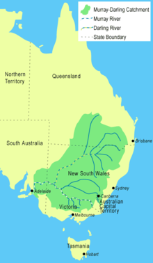 Map of the Murray-Darling Basin
The Murray-Darling basin is a large geographical area in the interior of southeastern Australia, whose name is derived from its two major rivers, the Murray River and the Darling River. It drains one-seventh of the Australian land mass,[1] and is currently by far the most significant agricultural area in Australia. It spans most of the states of New South Wales, Victoria, and the Australian Capital Territory, and parts of the states of Queensland (lower third) and South Australia (south-east corner). It is 3,375 kilometres (2,097 mi) in length (the Murray River is 2,589 km (1,609 mi) long).
Most of the 1,061,469 km2 (409,835 sq mi) basin is flat, low-lying and far inland, and receives little direct rainfall. The many rivers it contains tend to be long and slow-flowing, and carry a volume of water that is large only by Australian standards.
Contents
Native fauna
The Murray Darling Basin is home for many native animal species. The true numbers are not known, but a fairly confident estimate has been made of these animals and the current status of their population. Among the indigenous fauna in the region, the study found[citation needed] that there were:
- 85 species of mammals, with 20 extinct and 16 endangered.
- 53 species of frogs, with none endangered.
- 46 species of snakes, with 5 endangered.
- 5 species of tortoises, with none endangered
- 34 species of fish, with none endangered.
Introduced species
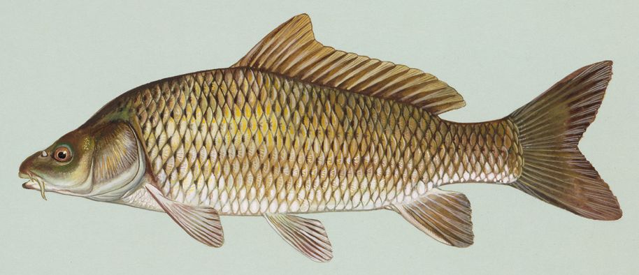
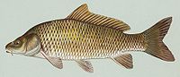 The carp, introduced in 1850, is now a trouble species in the Murray-Darling river system
The Basin has also played host to a variety of introduced species. One of the most well known is the carp.
Introduced in around 1851, the four varieties of carp were used to stock up fish dams. Since then they have made their way into the river systems, where they spread quite quickly. These fish are very mobile, as they can travel easily on flood waters and their eggs can be transported by birds.
These fish are a problem because they feed by sucking gravel from the river bed and taking all the edible material off it, before returning the rest to the water. This stirs up all the sediment, reducing the quality of the water. When caught by a fisherman, it must be killed by law.
Physiography
This area is one of the physiographic provinces of the larger East Australian Basins division, and encompasses the smaller Naracoorte Platform and Encounter Shelf physiographic sections.
Hydrology
Total water flow in the Murray-Darling basin 1885 to the present has averaged around 24,000 gigalitres per year. This is the lowest rate of the world's major river systems.[1] In most years only half of this quantity reaches the sea and in dry years much less. Estimated total annual flows for the basin have ranged from 5,000 gigalitres in 1902 to 57,000 gigalitres in 1956[citation needed]. Despite the magnitude of the basin, the hydrology of the streams within it is quite varied.
These waters are divided into three types:[2]
- The Darling and Lachlan basins. These have extremely variable flows from year to year, with the smallest annual flow being typically as little as 1 percent of the long-term mean and the largest often more than ten times the mean. Periods of zero flow in most rivers can extend to months and in the drier parts (Warrego, Paroo and Lower Darling basins) to years.[2] Flows in these rivers are not strongly seasonal. In the northern regions the majority of floods occur in the summer from monsoonal penetration. For most of the Darling and Lachlan catchments it is typical to see high or low flows begin in winter and extend to the following autumn (see El Niño). High water extraction rates for irrigation and mining have heavily compromised these rivers.
- The south-western basins (Campaspe, Loddon, Avoca, Wimmera). These have a marked winter rainfall maximum and relatively lower precipitation variability than the Lachlan or Darling. However, the age and infertility of the soils mean that run-off ratios are exceedingly low (for comparison, around a tenth that of a European or North American catchment with a similar climate[3]). Thus, variability of runoff is very high and most of the terminal lakes found in these basins very frequently dry up. Almost all runoff occurs in the winter and spring and, in the absence of large dams for regulation, these rivers are often seasonally dry during summer and autumn.
- A number of small catchments in South Australia, of which the largest are the Angas River flowing through Strathalbyn and the Finniss River further west, are part of the Murray-Darling Basin. These catchments lead to Lake Alexandrina, one of the lakes at the end of the Murray system. The Angas River is often dry in summer because of high levels of water extraction. The Finniss River has permanent flow which previously went into Lake Alexandrina but now has been cut off by a weir. The Finniss now fills the Goolwa Channel for recreational boating.
- The Murrumbidgee, Murray and Goulburn basins (except the Broken River which resembles the south-western basins). Because these catchments have headwaters in alpine country with relatively young peaty soils, the runoff ratios are much higher than in other parts of the basin. Consequently, although gross precipitation variability is no lower than in the Lachlan or Darling basins, runoff variability is markedly lower than in other parts of the basin. Typically these rivers never cease to flow and the smallest annual flow is typically around 30 percent of the long-term mean and the largest around three times the mean. In most cases the flow peaks very strongly with the spring snow melt and troughs in mid-autumn.
Of the approximately 13,000 gigalitres of flow in the basin, which studies have shown to be divertible, 11,500 gigalitres are removed for irrigation, industrial use, and domestic supply. Agricultural irrigation accounts for about 95% of the water removed,[1] including for the growing of rice and cotton. This extraction is highly controversial among scientists in Australia, regarding the agriculture industry's high water use in a region extremely short of water (as much due to exceptionally low run-off coefficients as to low rainfall).[4]
Rivers in the Murray-Darling Basin
- Darling River - western New South Wales: from the confluence of the Culgoa and Barwon rivers which, in turn, originate from tributaries in Queensland and northern and central New South Wales
- Culgoa River - from the most western branch of the Balonne River. Flows south-west to join the Darling River near Bourke, New South Wales
- Barwon River (New South Wales) forms a section of the border between the states of New South Wales and Queensland.
- Macintyre River (formed from rivers known as the "Border Rivers")
- Dumaresq River - also forms part of the border between the states of New South Wales and Queensland.
- Weir River (Queensland)
- Pike Creek (Queensland)
- Mole River (New South Wales),
- Beardy River NSW
- Macintyre Brook
- Beardy Waters NSW
- Bokhara River middle of three branches of the Balonne River whose main tributaries are the Condamine River from the northern Darling Downs, Qld and the Maranoa & Merivale Rivers, Qld.
- Mehi River - joins the Barwon River near Collarenebri
- Gwydir River - branches east of Moree, the main branch being the Mehi river.
- Horton River - drains most of the northern slopes of the Nandewar Range. Joins the Gwydir River between the towns of Bingara and Gravesend
- Rocky River (New South Wales) - joins the Gwydir River near Bundarra
- Namoi River - joins the Barwon River, near the town of Walgett
- Cobrabald River
- Cockburn River
- Macquarie River - headwaters rise in the central highlands of New South Wales near the town of Oberon
- Talbragar River
- Marra Creek
- Bogan River - rises at Goonumbla, 19 kilometres north-west of Parkes and flows in a north-westerly direction to join the Darling-Barwon near where the Culgoa river joins
- Warrego River - joins the Darling River below Bourke
- Murray River - designated as most of the border between New South Wales and Victoria
- Murrumbidgee River - NSW and ACT Tantangara Dam
- Molonglo River
- Gudgenby River
- Lachlan River - NSW
- Yass River
- Tumut River - joins the Murrumbidgee River, at Darbalara near the town of Gundagai.
- Goodradigbee River
- Numeralla River - joins the upper Murrumbidgee River near Bredbo.
- Avoca River
- Campaspe River - meets the Murray River near the town of Echuca
- Goulburn River
- Broken River
- Jamieson River
- Howqua River
- King River
- Buckland River
- Kiewa River - joins the Murray east of Albury.
- Mitta Mitta River - the source of approximately 40% of the Murray River's flow.
- Big River, just south of Anglers Rest, Victoria
Management
The basin covers five states and territory governments, who according to the Constitution, are responsible for managing water resources. The River Murray Commission was established in 1917.[1] Under the River Murray Waters Agreement, which never included Queensland despite the state containing about a quarter of the basin, the Commission's role was only as an advisory body with no authority for the enforcement of provisions. For a long time the Commission was only concerned with water quantity until salinity became a problem. This led to minor reforms in 1982 in which water quality became part of the Commission's responsibilities.[1] However, it was soon recognised that a new organisational structure which considered the national perspective was needed for effective management.
The Murray-Darling Basin Agreement was first adopted in 1985 but it wasn't until 1993 that its full legal status was in-acted.[1] The Agreement led to the creation of a number of new organisations under what is known as the Murray-Darling Basin Initiative. These included the Murray-Darling Basin Ministerial Council and the Murray Darling Basin Commission.
The Murray-Darling Basin Plan
In October 2010, The Murray-Darling Basin Authority released a major document outlining its plan to secure the long-term ecological health of the Murray-Darling Basin. This entails cutting existing water allocations and increasing environmental flows.[5] The document is officially titled the Guide to the Proposed Murray-Darling Basin Plan. It is the first part of a three-stage process to address the problems of the Murray-Darling Basin.[6] MDBA is responsible for preparing and overseeing a legally-enforceable management plan—the Basin Plan.
The Basin Plan is designed to set and enforce environmentally sustainable limits on the quantities of water that may be taken from Basin water resources, to set Basin-wide environmental, water quality and salinity objectives, to develop efficient water trading regimes across the Basin, to set requirements for state water resource plans and to improve water security for all Basin users.[7] It also intends to optimise social and economic impacts once these environmental outcomes have been met.[8]
With the release of the Guide to the Proposed Murray-Darling Basin Plan there have been a number of protests and voiced concerns about the plan in rural towns that the MDBA have visited to present the plan to consultation meetings.[9] Over 5,000 people attended a MDBA meeting in Griffith where Griffith Mayor, Mike Neville, said the plan would "obliterate" Murrumbidgee valley communities.[10] Other groups also echo this feeling, such as the Victorian Farmers Federation[11] and Wine Group Growers' Australia.[12] Conversely, support for the Murray-Darling Basin plan has been received by various groups, including Australian Conservation Foundation,[13] and Environment Victoria.[14]
New legal advice from lawyers for the Federal Government is changing the plan. The Government's reading is that the plan must give equal weight to the environmental, social and economic impacts of proposed cuts to irrigation. Environmentalists and South Australian irrigators, at the end of the river in South Australia, say the authority should stick to its original figure.[15]
In October 2010, a parliamentary inquiry into the economic impacts of the plan was announced.[16]
In late October 2010 the Water Minister, Tony Burke, played down the prospect of a High Court challenge to the Murray-Darling Basin plan, as confusion continued over new legal advice released by the Government. In response to community concerns that the Murray-Darling Basin Authority had put environmental issues first over social and economic needs, Burke released new advice on the requirements of the Water Act. Burke stated that the Act does allow for the authority to 'optimise' the needs of all three areas, but constitutional lawyer, George Williams, had cast doubts over the interpretation of the laws, stating it could be subject to a legal challenge.[17]
The MDBA announced in November 2010 that it might be forced to push back the release of its final plan for the river system until early 2012.[18]
The MDBA chairman, Mike Taylor, reassured the public meeting that more work is being done to look at how the proposed cuts would affect regional communities. He stated; "Importantly, we want to make sure the social and economic impacts—which under any sort of scenario is very significant—were fully teased out".[19] Taylor resigned as he believed that the overriding principle should be the environmental outcome which was in conflict with the Gillard Government and following a period of sustained criticism of the Authority and the implementation of the proposed draft basin plan.[20] He was replaced by former New South Wales Planning Minister, Craig Knowles.[21][22][23]
See also
References
- ^ a b c d e f Pigram, John J. (2007). Australia's Water Resources: From use to management. Collingwood, Victoria: CSIRO Pubishing. p. 160—162. ISBN 9780643094420.
- ^ a b Brown, J. A. H. (John Alexander Henstridge); Australia's Surface Water Resources. ISBN 0644026170
- ^ McMahon, T.A. and Finlayson, B.L.; Global Runoff: Continental Comparisons of Annual Flows and Peak Discharges; pp. 86-98 ISBN 3-923381-27-1.
- ^ Government, politics, power and policy in Australia / [editors] Dennis Woodward, Andrew Parkin, John Summers.
- ^ Joseph Thomsen (12 October 2010). "MDBA Chair explains water allocation cuts". ABC Goulburn Murray (Australian Broadcasting Corporation). http://www.abc.net.au/local/stories/2010/10/12/3036291.htm. Retrieved 17 October 2010.
- ^ The Murray-Darling Plan explained. Sarah Clarke and staff. 8 October 2010. ABC News Online. Australian Broadcasting Corporation.
- ^ Summary of Murrumbidgee Region From the Guide to the proposed Basin Plan
- ^ Tom Arup (31 May 2010). "Joyce signals fight over plan for Murray-Darling Basin". The Sydney Morning Herald (Fairfax Media). http://www.smh.com.au/environment/water-issues/joyce-signals-fight-over-plan-for-murraydarling-basin-20100530-wnj1.html. Retrieved 17 October 2010.
- ^ Tractor convoy as SA irrigators protest 15 October 2010. Australian Broadcasting Corporation
- ^ "Griffith irrigators vent anger". Weekly Times. 20 October 2010. http://www.weeklytimesnow.com.au/article/2010/10/21/248661_water.html. Retrieved 21 October 2010.
- ^ VFF Declares War!: Stop the MDBA plundering.
- ^ Federal Government urged ‘not to forget people’ in Basin Plan. Media Release. 13 October 2010.
- ^ Cautious support from scientists for the emerging Murray‐Darling Basin Plan.
- ^ Murray-Darling Basin Plan – what’s it all about? 11 March 2010.
- ^ Jason Om. (27 October 2010). SA irrigators back Murray-Darling cuts. ABC News.
- ^ Tim Lee. (18 October 2010). Murray authority chairman faces uphill battle. ABC News.
- ^ Emma Rodgers. (28 OCtober 2010) Burke plays down challenge to basin plan. ABC News.
- ^ Kerrin Binnie. (2 November 2010) Basin authority flags delay to final plan. ABC News.
- ^ (4 November 2010). Water cuts treat farmers as 'second-class citizens'. ABC News.
- ^ Rodgers, Emma (7 December 2010). "Murray-Darling boss resigns". ABC News (Australian Broadcasting Corporation). http://www.abc.net.au/news/stories/2010/12/07/3086516.htm?section=justin.
- ^ Coorey, Phillip (28 January 2011). "Ex-NSW minister Craig Knowles to be Murray Darling supremo". The Sydney Morning Herald (Fairfax Media). http://www.smh.com.au/environment/water-issues/exnsw-minister-craig-knowles-to-be-murray-darling-supremo-20110128-1a7jh.html. Retrieved 28 January 2011.
- ^ Coorey, Phillip (29 January 2011). "A cosy number for a party mate or the right man for the job?". The Sydney Morning Herald (Fairfax Media). http://www.smh.com.au/environment/water-issues/a-cosy-number-for-a-party-mate-or-the-right-man-for-the-job-20110128-1a8dv.html. Retrieved 29 January 2011.
- ^ Kruger, Paula (28 January 2011). "'Jobs for mate' claims dog new Murray-Darling chief". ABC News (Australian Broadcasting Corporation). http://www.abc.net.au/news/stories/2011/01/28/3124581.htm. Retrieved 29 January 2011.
External links
- Murray-Darling Basin Authority
- Murray-Darling Basin Water Budget Project
- Murray Darling Freshwater Research Centre
- River Murray Water Restrictions
- Murray Outback - Guide to the major towns on the Murray and Murray Outback Region.
- Save the Murray - lobby group
- Murray Darling Basin Resources
- The Basin Plan
- Guide to the Proposed Basin Plan
- Guide to the Basin Plan, Volumes 1 - 21
- Basin Plan - lobby group
- News
- Fire, Flood and Acid Mud - ABC TV Catalyst
- "The Murray-Darling plan explained". ABC Online. 8 October 2010. http://www.abc.net.au/news/stories/2010/10/06/3030629.htm.
Categories:- Regions of Australia
- Drainage basins of Australia
- Physiographic provinces
- Murray-Darling basin
- Biosphere reserves of Australia

Wikimedia Foundation. 2010.