- Mary Jane Thurston State Park
-
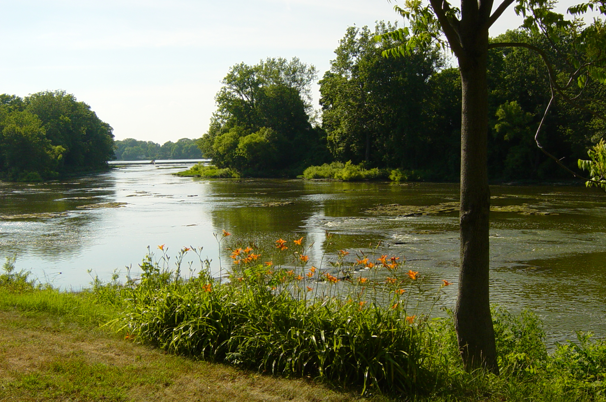
Mary Jane Thurston State Park Ohio State Park Natural Monument (IUCN III) 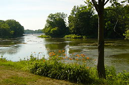 The Maumee River at Mary Jane Thurston State Park
Named for: Mary Jane Thurston Country United States State Ohio Counties Wood and Henry Location [1] - coordinates 41°24′37″N 83°52′40″W / 41.41028°N 83.87778°WCoordinates: 41°24′37″N 83°52′40″W / 41.41028°N 83.87778°W - elevation 640 ft (195 m) [1] Area 591 acres (239 ha) Founded 1968 Managed by Ohio Department of Natural Resources Division of Parks and Recreation 
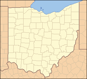
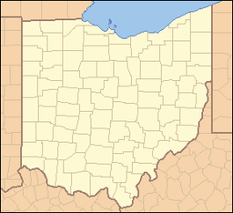 Location of Mary Jane Thurston State Park in Ohio
Website : Mary Jane Thurston State Park Mary Jane Thurston State Park is a 591-acre (239 ha) Ohio state park in Wood and Henry Counties, Ohio in the United States. It is named for Mary Jane Thurston, a schoolteacher from Grand Rapids, Ohio who bequeathed 14 acres (57,000 m2) of land for the establishment of a park. The park is along the Maumee River near the remains of the historic Miami and Erie Canal. Mary Jane Thurston State Park is open for year-round recreation including, hunting, fishing and boating, picnicking, camping and hiking.[2]
Contents
History
Mary Jane Thurston State Park is near the confluence of the Auglaize and Maumee rivers. This area has played a key role in the history of northwest Ohio. The rivers provided a travel route for numerous Indian tribes including the Iroquois, Miami, Lenape, Ottawa, Erie, Wyandot, and Shawnee. Anglo-American explorers were also drawn to the rivers for many of the same reasons as the Native Americans. It provided a reliable source of water as well as an abundance of fish and game.[2]
President George Washington dispatched General Anthony Wayne and his army to the Northwest Territory to put down an Indian uprising, led by the Shawnee leader Blue Jacket. Wanye built Fort Defiance and defeated Blue Jacket at the Battle of Fallen Timbers. After the Native Americans were driven out and west, the land was opened to settlement by Anglo-Americans. Homesteaders arrived soon after. They cleared the land and began farming.[2]
The Miami and Erie and Wabash and Erie Canals passed through an area now included in the park. The canals connected the Ohio River with Lake Erie. Cities such as Defiance grew along the banks of the canal. They developed into trade and industrial centers. The canal system thrived for about thirty years in the mid to late 19th century before they were replaced the railroads.[2]
There were challenges keeping enough water in the canals during the 1840s. The state of Ohio built a large dam across the Maumee River at Gilead in 1845. This dam replaced a smaller dam that had been built to provide power to a mill. This act outraged the citizens of Gilead since the new dam restricted the water power provided to the mill. The upset residents of the community destroyed the dam.[2] Following the destruction of the dam a side cut canal was built that connected Gilead with the main canal. This caused an economic boom in Gilead and the village was incorporated as Grand Rapids in 1855.[2]
The first 14 acres (57,000 m2) of the Mary Jane Thurston State Park were donated by the park's namesake, Mary Jane Thurston. She was a teacher in Grand Rapids. Thurston donated her land in 1928 and over a period of 40 years land surrounding the Thurston plot was acquired. Mary Jane Thurston, which is 591 acres (2.39 km2), was opened to the public in 1968.[2]
Geography
Mary Jane Thurston State Park is in the Maumee Valley. This valley was formerly covered by Lake Maumee which was a remnant of the last ice age. The lake stretched from what is now Fort Wayne, Indiana to western New York state. The waters from Lake Maumee eventually shifted creating Lake Erie and the Maumee Valley was formed.[2]
The Maumee Valley has been changed tremendously since it was settled after the Northwest Indian War. It was in the middle of the Great Black Swamp which was 30 to 40 miles (64 km) wide and about 120 miles (190 km) long. It was a heavily forested area that was home to massive sycamore trees that were converted into barns and in some cases homes. Oak and tulip trees were mixed in with the sycamore and walnut. Nearly every tree was cut in less than 100 years after the settlement of Ohio.[2]
The Maumee Valley was one of the last areas of Ohio to be cleared. The swampy ground made it difficult for settlers to enter. The swamp was drained between 1859 and 1875 with a series of ditches and drains. Nearly 2,500,000 acres (10,000 km2) of land were cleared after the swamps were emptied. The region was covered with farms, as it is today, by 1885. Only six percent of the Maumee Valley is now covered with forests, some of this land is in Mary Jane Thurston State Park and up and down the Maumee River from the park.[2]
Recreation
Mary Jane Thurston State Park is open for year round recreation. There are 35 campsites at the park. All campsites come equipped with picnic tables and fire rings. There is a public restroom facility in the camping area. The Maumee River is open to all types of boating with two launch ramps at the park. Hunting and fishing are both permitted at the park. Common game animals include White-tailed deer and Wild Turkeys. The river is home to a variety of fresh water fish species including, northern pike, bullhead catfish, smallmouth bass and crappie. All hunters and anglers must have a valid license issued by the state. Numerous picnic tables are spread throughout the park. The Buckeye Trail passes through Mary Jane Thurston State Park for one mile (1.6 km).[2]
References
- ^ a b "Mary Jane Thurston State Park". Geographic Names Information System. United States Geological Survey. July 12, 1979. http://geonames.usgs.gov/pls/gnispublic/f?p=gnispq:3:::NO::P3_FID:1056545. Retrieved 2008-12-27.
- ^ a b c d e f g h i j k "Mary Jane Thurston State Park". Ohio Department of Natural Resources Division of Parks and Recreation. http://www.dnr.state.oh.us/parks/tabid/768/Default.aspx. Retrieved 2008-12-27.
Protected areas of Ohio Federal National parksState Adams Lake • Alum Creek • A. W. Marion • Barkcamp • Beaver Creek • Blue Rock • Buck Creek • Buckeye Lake • Burr Oak • Caesar Creek • Catawba Island • Cleveland Lakefront • Cowan Lake • Deer Creek • Delaware • Dillon • East Fork • East Harbor • Findley • Forked Run • Geneva • Grand Lake St. Marys • Great Seal • Guilford Lake • Harrison Lake • Headlands Beach • Hocking Hills • Hueston Woods • Independence Dam • Indian Lake • Jackson Lake • Jefferson Lake • John Bryan • Kelleys Island • Kiser Lake • Lake Alma • Lake Hope • Lake Logan • Lake Loramie • Lake Milton • Lake White • Little Miami • Madison Lake • Malabar Farm • Marblehead Lighthouse • Mary Jane Thurston • Middle Bass Island • Maumee Bay • Mohican • Mosquito Lake • Mt. Gilead • Muskingum River • Nelson Kennedy Ledges • Paint Creek • Pike Lake • Portage Lakes • Punderson • Pymatuning • Quail Hollow • Rocky Fork • Salt Fork • Scioto Trail • Shawnee • South Bass Island • Stonelick • Strouds Run • Sycamore • Tar Hollow • Tinkers Creek • Van Buren • West Branch • Wingfoot Lake • Wolf Run
Beaver Creek • Blue Rock • Brush Creek • Dean • Fernwood • Gifford • Harrison • Hocking • Maumee • Mohican-Memorial • Perry • Pike • Richland Furnace • Scioto Trail • Shade River • Shawnee • Sunfish Creek • Tar Hollow • Yellow Creek • Zaleski
State nature
preservesAcadia Cliffs • Adams Lake Prairie • Audubon Islands • Augusta-Anne Olsen • Aurora Sanctuary • Baker Woods • Evans Beck Memorial • Betsch Fen • Bigelow Cemetery • Blackhand Gorge • Bonnet Pond • Boord • Brown's Lake Bog • Burton Wetlands • Caesar Creek Gorge • Lou Campbell • Carmean Woods • Cedar Bog • Chaparral Prairie • Christmas Rocks • Clear Creek • Clear Fork Gorge • Clifton Gorge • Howard Collier • Compass Plant Prairie • Conkle's Hollow • Copperrider-Kent Bog • Crabill Fen • Cranberry Bog • Crane Hollow • Crooked Run • Culberson Woods • Davey Woods • Davis Memorial • Marie J. Desonier • Drew Woods • Dupont Marsh • Eagle Creek • Emerald Hills • Erie Sand Barrens • Etawah Woods • Flatiron Lake Bog • Fowler Woods • Frame Lake Fen • Gahanna Woods • Gallagher/Springfield Fen • Goll Woods • Goode Prairie • Gott Fen • Greenbelt • Greenville Falls • Gross Memorial Woods • Hatch-Otis • Halls Creek • Headlands Dunes • Hueston Woods • Hutchins (Highland) • Irwin Prairie • Jackson Bog • Johnson Ridge • Johnson Woods • Karlo Fen • Kendrick Woods • Kessler Swamp • Kiser Lake Wetlands • Kitty Todd • Knox Woods • Kyle Woods • Ladd Natural Bridge • Lake Katharine • Lakeside Daisy • Lawrence Woods • Little Rocky Hollow • Mantua Bog • Marsh Wetlands • McCracken Fen • Mentor Marsh • Milford Center Railroad Prairie • Miller • Morris Woods • Mud Lake Bog • Myersville • Newberry • North Pond • North Shore Alvar • Novak Sanctuary • Old Woman Creek • Owens/Liberty Fen • Pallister • Pickerington Ponds • Portage Lakes Wetland • Prairie Road Fen • William C. McCoy • Raven Rock • Rhododendeon Cove • Rockbridge • Rome • Rothenbuhler Woods • Saltpetre Cave • Sears Woods • Seymour Woods • Shallenberger • Sharon Woods Gorge • Sheepskin Hollow • Sheick Hollow • Sheldon Marsh • Shoemaker • Siegenthaler-Kaestner Esker • Smith Cemetery • Spring Beauty Dell • Spring Brook Sanctuary • Springville Marsh • Stage's Pond • Strait Creek Prairie • Stratford Woods • Swamp Cottonwood • Edward Thomas • Tinker's Creek • Travertine Fen • Triangle Lake Bog • Trillium Trails • Walter Tucker • Tummonds • Warder-Perkins • Whipple • White Pine Bog Forest • Zimmermand Prairie
State
scenic riversBig Darby Creek • Chagrin River • Conneaut Creek • Cuyahoga River • Grand River • Greenville Creek • Kokosing River • Little Beaver Creek • Little Darby Creek • Little Miami River • Maumee River • Mohican River • Olentangy River • Sandusky River • Stillwater River
Regional Ashtabula County Metroparks • Cleveland Metroparks • Columbus Metro Parks • Erie MetroParks • Five Rivers MetroParks • Geauga Park District • Hamilton County Park District • Johnny Appleseed Metro Parks • Lake Metroparks • Lorain County Metro Parks • Metroparks of Butler County • Metro Parks, Serving Summit County • Metroparks of the Toledo Area • Mill Creek MetroParks • Trumbull County MetroParks •
Ohio Department of Natural Resources (web) Categories:- Ohio state parks
- Protected areas of Wood County, Ohio
- Protected areas established in 1968
- Protected areas of Henry County, Ohio
Wikimedia Foundation. 2010.