- Caesar Creek State Park
-
Caesar Creek State Park Location Warren / Clinton / Greene counties, Ohio, USA Nearest city Waynesville, Ohio Coordinates 39°31′20″N 84°0′50″W / 39.52222°N 84.01389°WCoordinates: 39°31′20″N 84°0′50″W / 39.52222°N 84.01389°W Area 3,741 acres (1,514 ha) land 2,830 acres (1,150 ha) water Established 1978 Governing body Ohio Department of Natural Resources Caesar Creek Lake 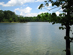
Location Warren / Clinton counties, Ohio, USA Coordinates 39°29′07″N 84°03′55″W / 39.48528°N 84.06528°W Lake type reservoir Primary inflows Caesar Creek Primary outflows Caesar Creek Basin countries United States Surface area 2,830 acres (1,150 ha) Caesar Creek State Park is located in southwestern Ohio, five miles (8 km) east of Waynesville, in Warren, Clinton, and Greene Counties. The park is leased by the State from the U.S. Army Corps of Engineers, who in the 1970s erected a dam on Caesars Creek to impound a 2,830-acre (1,150 ha) lake. The total park area, including the lake, is 7,941-acre (3,214 ha). The park has 43 miles (69 km) of hiking trails and 31 miles (50 km) of bridle trails.
The Army Corps site states:
- Congress authorized Caesar Creek Lake under the Flood Control Act of 1938. The Louisville District of the U.S. Army Corps of Engineers designed, built, and operates Caesar Creek Lake.
- During the fall and winter months, the lake level is lowered to prepare for the storage of heavy spring rainfall. If heavy rains occur, surface water runoff is stored in the lake until the swollen streams and rivers below the dam have receded. Once they can handle the discharge of the stored water without damage to lives or property, the extra water is released.
The dam is an earth and rock fill dam 165 feet (50 m) high and 2,750 feet (840 m) long. The Army Corps site is an area of 10,550 acres (4,270 ha). The watershed above the dam has an area of 237 square miles (61,000 ha). Construction started in 1971 and was finished in 1978.
The village of New Burlington was flooded by the lake. The site is in the Warren County townships of Massie and Wayne.
Amenities
- Caesar's Creek Pioneer Village - a collection of over 15 log cabins and other structures that are open during special events. The village is maintained and operated by a private non-profit organization. The buildings include a Quaker meetinghouse, a broom shed, a pioneer school house, blacksmith shop, carpenter shop, toll house and many family houses.
- Caesar Creek Nature Center - Adjacent to the Pioneer Village, the nature center features exhibits on the area's cultural and natural history. Nature education programs are offered year round, including campouts, hikes and a maple syrup program.
References
- John Baskin. New Burlington: The Life and Death of an American Village. New York: W. W. Norton, 1976. ISBN 0-393-08366-7
- Ohio. Department of Natural Resources. Division of Geological Survey. Excursion to Caesar Creek State Park in Warren County, Ohio. By Douglas L. Shrake. Geological Survey Guidebook No. 12. Columbus, Ohio: The Department, 1992
- United States Department of Agriculture. Natural Resources Conservation Service. Caesar Creek Watershed, Miami Valley Resource Conservation and Development Area : Clinton, Greene, and Warren Counties, Ohio. Fort Worth, Texas: The Service, 1995.
- United States. Department of the Army. Corps of Engineers. Louisville District. Final Updated Environmental Impact Statement: Caesar Creek Lake Project, Ohio. Louisville, Kentucky: The Corps, 1974.
- Art Weber. Ohio State Parks. Saginaw, Michigan: Glovebox Guidebooks, 1995. ISBN 1-881139-04-2.
External links
- Official State Park Website - includes information about the nature center programs
- Official ODNR Website (with links for reservations)
- Park map
- Caesar Creek Lake fishing map
- Caesars Creek Gorge
- Another site on the park
- Friends of Caesars Creek
- Army Corps page on the lake
- Ohio's State fossil
Protected areas of Ohio Federal National parksCedar Point • Ottawa • West Sister IslandState Adams Lake • Alum Creek • A. W. Marion • Barkcamp • Beaver Creek • Blue Rock • Buck Creek • Buckeye Lake • Burr Oak • Caesar Creek • Catawba Island • Cleveland Lakefront • Cowan Lake • Deer Creek • Delaware • Dillon • East Fork • East Harbor • Findley • Forked Run • Geneva • Grand Lake St. Marys • Great Seal • Guilford Lake • Harrison Lake • Headlands Beach • Hocking Hills • Hueston Woods • Independence Dam • Indian Lake • Jackson Lake • Jefferson Lake • John Bryan • Kelleys Island • Kiser Lake • Lake Alma • Lake Hope • Lake Logan • Lake Loramie • Lake Milton • Lake White • Little Miami • Madison Lake • Malabar Farm • Marblehead Lighthouse • Mary Jane Thurston • Middle Bass Island • Maumee Bay • Mohican • Mosquito Lake • Mt. Gilead • Muskingum River • Nelson Kennedy Ledges • Paint Creek • Pike Lake • Portage Lakes • Punderson • Pymatuning • Quail Hollow • Rocky Fork • Salt Fork • Scioto Trail • Shawnee • South Bass Island • Stonelick • Strouds Run • Sycamore • Tar Hollow • Tinkers Creek • Van Buren • West Branch • Wingfoot Lake • Wolf Run
Beaver Creek • Blue Rock • Brush Creek • Dean • Fernwood • Gifford • Harrison • Hocking • Maumee • Mohican-Memorial • Perry • Pike • Richland Furnace • Scioto Trail • Shade River • Shawnee • Sunfish Creek • Tar Hollow • Yellow Creek • Zaleski
State nature
preservesAcadia Cliffs • Adams Lake Prairie • Audubon Islands • Augusta-Anne Olsen • Aurora Sanctuary • Baker Woods • Evans Beck Memorial • Betsch Fen • Bigelow Cemetery • Blackhand Gorge • Bonnet Pond • Boord • Brown's Lake Bog • Burton Wetlands • Caesar Creek Gorge • Lou Campbell • Carmean Woods • Cedar Bog • Chaparral Prairie • Christmas Rocks • Clear Creek • Clear Fork Gorge • Clifton Gorge • Howard Collier • Compass Plant Prairie • Conkle's Hollow • Copperrider-Kent Bog • Crabill Fen • Cranberry Bog • Crane Hollow • Crooked Run • Culberson Woods • Davey Woods • Davis Memorial • Marie J. Desonier • Drew Woods • Dupont Marsh • Eagle Creek • Emerald Hills • Erie Sand Barrens • Etawah Woods • Flatiron Lake Bog • Fowler Woods • Frame Lake Fen • Gahanna Woods • Gallagher/Springfield Fen • Goll Woods • Goode Prairie • Gott Fen • Greenbelt • Greenville Falls • Gross Memorial Woods • Hatch-Otis • Halls Creek • Headlands Dunes • Hueston Woods • Hutchins (Highland) • Irwin Prairie • Jackson Bog • Johnson Ridge • Johnson Woods • Karlo Fen • Kendrick Woods • Kessler Swamp • Kiser Lake Wetlands • Kitty Todd • Knox Woods • Kyle Woods • Ladd Natural Bridge • Lake Katharine • Lakeside Daisy • Lawrence Woods • Little Rocky Hollow • Mantua Bog • Marsh Wetlands • McCracken Fen • Mentor Marsh • Milford Center Railroad Prairie • Miller • Morris Woods • Mud Lake Bog • Myersville • Newberry • North Pond • North Shore Alvar • Novak Sanctuary • Old Woman Creek • Owens/Liberty Fen • Pallister • Pickerington Ponds • Portage Lakes Wetland • Prairie Road Fen • William C. McCoy • Raven Rock • Rhododendeon Cove • Rockbridge • Rome • Rothenbuhler Woods • Saltpetre Cave • Sears Woods • Seymour Woods • Shallenberger • Sharon Woods Gorge • Sheepskin Hollow • Sheick Hollow • Sheldon Marsh • Shoemaker • Siegenthaler-Kaestner Esker • Smith Cemetery • Spring Beauty Dell • Spring Brook Sanctuary • Springville Marsh • Stage's Pond • Strait Creek Prairie • Stratford Woods • Swamp Cottonwood • Edward Thomas • Tinker's Creek • Travertine Fen • Triangle Lake Bog • Trillium Trails • Walter Tucker • Tummonds • Warder-Perkins • Whipple • White Pine Bog Forest • Zimmermand Prairie
State
scenic riversBig Darby Creek • Chagrin River • Conneaut Creek • Cuyahoga River • Grand River • Greenville Creek • Kokosing River • Little Beaver Creek • Little Darby Creek • Little Miami River • Maumee River • Mohican River • Olentangy River • Sandusky River • Stillwater River
Regional Ashtabula County Metroparks • Cleveland Metroparks • Columbus Metro Parks • Erie MetroParks • Five Rivers MetroParks • Geauga Park District • Hamilton County Park District • Johnny Appleseed Metro Parks • Lake Metroparks • Lorain County Metro Parks • Metroparks of Butler County • Metro Parks, Serving Summit County • Metroparks of the Toledo Area • Mill Creek MetroParks • Trumbull County MetroParks •
Categories:- Protected areas of Warren County, Ohio
- Protected areas of Clinton County, Ohio
- Protected areas of Greene County, Ohio
- Ohio state parks
- Reservoirs in Ohio
- Dams in Ohio
- Nature centers in Ohio
- Protected areas established in 1978
- Education in Warren County, Ohio

Wikimedia Foundation. 2010.