- Mohican State Park
-
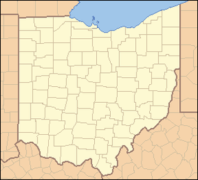
Mohican State Park Map of the U.S. state of Ohio showing the location of Mohican State Park Location Ashland County, Ohio, USA Nearest city Loudonville Coordinates 40°36′32.6″N 82°15′46.7″W / 40.609056°N 82.262972°WCoordinates: 40°36′32.6″N 82°15′46.7″W / 40.609056°N 82.262972°W Established 1949 Governing body Ohio Department of Natural Resources Mohican State Park is a 1,110-acre (4.5 km2) Ohio state park in Ashland County, Ohio, United States, located about 5 miles (8.0 km) south of downtown Loudonville, Ohio. The state park is surrounded by the 4,525-acre (18.31 km2) Mohican-Memorial State Forest. Mohican State Park is located along Ohio SR 3 and Ohio SR 97. The Clear Fork of the Mohican River flows through the park and joins the Black Fork about a half-mile east of the park to form the Mohican River. The park is open for year-round recreation including camping, hiking, boating, mountain biking, fishing, and picnicking.
There are three separate camping areas at Mohican State Park: the Class A Campground, the Class B Campground, and the Group Camp Area. There is also the Mohican Resort and Conference Center, built in 1974 and now operated by Xanterra Parks and Resorts, located 10 miles (16 km) west of the park.
In the Class A Campground located off of Ohio SR 3, there are 33 full service hook-up sites, 118 electric-only sites, and 10 walk-in tent camping sites. In addition, there are 25 Cottages near the west end of the Class A Campground along the Clear Fork and three Camper Cabins near the front of Class A. Campers can purchase souvenirs and gifts, camping supplies, some grocery items, and ice cream and coffee at The Commissary located in Class A. A game room is attached to the store, and guests may also sign out basketballs, volleyballs, and horseshoes for their personal use.
The Class B Campground is located approximately two miles west of the Class A Campground, located off of Ohio SR 97. The Class B Campground is near the covered bridge along the Clear Fork and has 24 electric-only sites, all of which are available on a first-come, first-serve basis.
Contents
History of the Area
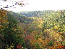
The erosional forces of the last glacial meltwaters 12,000 years ago hastened the carving of the narrow gorge of the Clear Fork of the Mohican River. This gorge cuts into the sandstone bedrock exposing huge outcroppings and creating steep cliff walls. The gorge is more than one thousand feet wide at the top and over three hundred feet deep. The striking Clearfork Gorge with its towering hemlocks and stands of old-growth white pine are of national significance. The National Park Service has thus dedicated the area as a Registered National Natural Landmark.
The Mohican State Park area was once the hunting grounds of the Lenape, whose more famous warriors included Janacake, Bill Montour, Thomas Lyon, and James Smith, who was the first white man to come to this area. Smith was captured by the Indians and later adopted into their tribe. Several Delaware villages were located in the Mohican vicinity.
Settlement by non-Indians began at the turn of the nineteenth century, but settlement did not increase until the Indians were driven from the area during the War of 1812. John Chapman, immortalized as Johnny Appleseed, frequented the region during the 1800's, caring for his apple tree nurseries. His name and the date, carved in the wall of Lyons Falls, were an attraction for years. Unfortunately, the etchings have been obliterated with the passage of time.
Mohican State Park was originally called Clear Fork State Park when the Ohio Department of Natural Resources was created in 1949 and the park was created from Ohio Division of Forestry lands. In 1966, the name of the park was changed to Mohican to alleviate confusion between Clear Fork Reservoir in Mansfield, Ohio and the state park.
Activities
Hiking
There are 13 miles (21 km) of hiking trails in Mohican State Park, plus an additional 32 miles (51 km) of hiking trails in the adjacent State Forest. The designated mountain bike trails and bridle paths are also available for the hiker to use.
Mountain Biking
An 8.5-mile (13.7 km) mountain bike trail that passes through Mohican State Park and the State Forest was opened to the public in 2005. The trail was created through a partnership between the Mohican/Malabar Bike Club and ODNR. Since then, work has continued to expand the mountain bike trail to a total of 24.5 miles (39.4 km). The trail is open both to mountain bike riders and hikers. Each June the park is home to the Mohican MTB 100 race.
Naturalist Programs
From Memorial Day Weekend through the Sunday of Labor Day Weekend, the park offers daily naturalist activities for its camping and cottage visitors as well as the general public. Activities include movies at the Class A Campground amphitheater on weekends, nature hikes, family games, and grist mill tours. In addition, the Junior Naturalist program is offered for kids from ages 7 through 14. A restored cabin serves as the park Nature Center and is located in the Class A Campground.
Malabar Farm State Park is located approximately 15 miles (24 km) west of Mohican State Park, just west of Pleasant Hill Lake.
External links
Protected areas of Ohio Federal National parksCedar Point • Ottawa • West Sister IslandState Adams Lake • Alum Creek • A. W. Marion • Barkcamp • Beaver Creek • Blue Rock • Buck Creek • Buckeye Lake • Burr Oak • Caesar Creek • Catawba Island • Cleveland Lakefront • Cowan Lake • Deer Creek • Delaware • Dillon • East Fork • East Harbor • Findley • Forked Run • Geneva • Grand Lake St. Marys • Great Seal • Guilford Lake • Harrison Lake • Headlands Beach • Hocking Hills • Hueston Woods • Independence Dam • Indian Lake • Jackson Lake • Jefferson Lake • John Bryan • Kelleys Island • Kiser Lake • Lake Alma • Lake Hope • Lake Logan • Lake Loramie • Lake Milton • Lake White • Little Miami • Madison Lake • Malabar Farm • Marblehead Lighthouse • Mary Jane Thurston • Middle Bass Island • Maumee Bay • Mohican • Mosquito Lake • Mt. Gilead • Muskingum River • Nelson Kennedy Ledges • Paint Creek • Pike Lake • Portage Lakes • Punderson • Pymatuning • Quail Hollow • Rocky Fork • Salt Fork • Scioto Trail • Shawnee • South Bass Island • Stonelick • Strouds Run • Sycamore • Tar Hollow • Tinkers Creek • Van Buren • West Branch • Wingfoot Lake • Wolf Run
Beaver Creek • Blue Rock • Brush Creek • Dean • Fernwood • Gifford • Harrison • Hocking • Maumee • Mohican-Memorial • Perry • Pike • Richland Furnace • Scioto Trail • Shade River • Shawnee • Sunfish Creek • Tar Hollow • Yellow Creek • Zaleski
State nature
preservesAcadia Cliffs • Adams Lake Prairie • Audubon Islands • Augusta-Anne Olsen • Aurora Sanctuary • Baker Woods • Evans Beck Memorial • Betsch Fen • Bigelow Cemetery • Blackhand Gorge • Bonnet Pond • Boord • Brown's Lake Bog • Burton Wetlands • Caesar Creek Gorge • Lou Campbell • Carmean Woods • Cedar Bog • Chaparral Prairie • Christmas Rocks • Clear Creek • Clear Fork Gorge • Clifton Gorge • Howard Collier • Compass Plant Prairie • Conkle's Hollow • Copperrider-Kent Bog • Crabill Fen • Cranberry Bog • Crane Hollow • Crooked Run • Culberson Woods • Davey Woods • Davis Memorial • Marie J. Desonier • Drew Woods • Dupont Marsh • Eagle Creek • Emerald Hills • Erie Sand Barrens • Etawah Woods • Flatiron Lake Bog • Fowler Woods • Frame Lake Fen • Gahanna Woods • Gallagher/Springfield Fen • Goll Woods • Goode Prairie • Gott Fen • Greenbelt • Greenville Falls • Gross Memorial Woods • Hatch-Otis • Halls Creek • Headlands Dunes • Hueston Woods • Hutchins (Highland) • Irwin Prairie • Jackson Bog • Johnson Ridge • Johnson Woods • Karlo Fen • Kendrick Woods • Kessler Swamp • Kiser Lake Wetlands • Kitty Todd • Knox Woods • Kyle Woods • Ladd Natural Bridge • Lake Katharine • Lakeside Daisy • Lawrence Woods • Little Rocky Hollow • Mantua Bog • Marsh Wetlands • McCracken Fen • Mentor Marsh • Milford Center Railroad Prairie • Miller • Morris Woods • Mud Lake Bog • Myersville • Newberry • North Pond • North Shore Alvar • Novak Sanctuary • Old Woman Creek • Owens/Liberty Fen • Pallister • Pickerington Ponds • Portage Lakes Wetland • Prairie Road Fen • William C. McCoy • Raven Rock • Rhododendeon Cove • Rockbridge • Rome • Rothenbuhler Woods • Saltpetre Cave • Sears Woods • Seymour Woods • Shallenberger • Sharon Woods Gorge • Sheepskin Hollow • Sheick Hollow • Sheldon Marsh • Shoemaker • Siegenthaler-Kaestner Esker • Smith Cemetery • Spring Beauty Dell • Spring Brook Sanctuary • Springville Marsh • Stage's Pond • Strait Creek Prairie • Stratford Woods • Swamp Cottonwood • Edward Thomas • Tinker's Creek • Travertine Fen • Triangle Lake Bog • Trillium Trails • Walter Tucker • Tummonds • Warder-Perkins • Whipple • White Pine Bog Forest • Zimmermand Prairie
State
scenic riversBig Darby Creek • Chagrin River • Conneaut Creek • Cuyahoga River • Grand River • Greenville Creek • Kokosing River • Little Beaver Creek • Little Darby Creek • Little Miami River • Maumee River • Mohican River • Olentangy River • Sandusky River • Stillwater River
Regional Ashtabula County Metroparks • Cleveland Metroparks • Columbus Metro Parks • Erie MetroParks • Five Rivers MetroParks • Geauga Park District • Hamilton County Park District • Johnny Appleseed Metro Parks • Lake Metroparks • Lorain County Metro Parks • Metroparks of Butler County • Metro Parks, Serving Summit County • Metroparks of the Toledo Area • Mill Creek MetroParks • Trumbull County MetroParks •
Ohio Department of Natural Resources (web) Categories:- Protected areas of Ashland County, Ohio
- Ohio state parks
- Protected areas established in 1949
- Mountain biking venues in the United States
Wikimedia Foundation. 2010.


