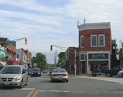
- Chesterton Commercial Historic District
-
Chesterton Commercial Historic District
 I.O.O.F. Lodge (Antique Shop Building)
Location: 109-193 N. Calumet Rd. and 130-134 N. Calumet Rd., Chesterton, Indiana Coordinates: 41°36′39″N 87°3′8″W / 41.61083°N 87.05222°WCoordinates: 41°36′39″N 87°3′8″W / 41.61083°N 87.05222°W Area: 3.2 acres (1.3 ha) Built: 1902 Architectural style: Italianate, Romanesque Governing body: Private NRHP Reference#: 99001102[1] Added to NRHP: September 09, 1999 The Chesterton Commercial Historic District is a historic district in Chesterton, Indiana.
Originally called Coffee Creek and located a little to the south of the current downtown, the name was changed some time after the post office was established in 1833 to Calumet, the river to the north. When the Lake Shore and Michigan Railroad came through the area in 1852, the town moved north to the current location and began to develop. The town's name was not changed to Chesterton until after the Civil War. There appears to have been confusion with Calumet, Illinois, further up the track.[2]
The town’s location along the railroad helped industry to grow. Soon, there was a cooperage, sawmills, a washing machine factory, and an organ company. Among the better examples of the towns growth are the commercial building on the southwest corner of Broadway and Calumet Rd, and the old Chesterton Tribune Building.[2]
Key buildings
South of Broadway on the west side of Calumet Road are two historic buildings.
- I.O.O.F Lodge - The International Order of Odd Fellows Lodge was built c. 1905, shortly after the devastating fire of 1902.[2]
- The Queen Anne Commercial building on the southwest corner of Broadway and Calumet Road was built c. 1895. This building is considered a ‘notable’ property which substantially supports the historic integrity of the district.[2]
The bulk of the historic district in on the east side of Calumet Road. The southern end of the district starts across from Indiana Ave. It runs north to the tracks.
- The Chesterton Tribune Building is the most southern building and was built c. 1905 after the great fire of 1902. It is considered a Twentieth Century function style, similar to most of the buildings in the district.[2]
- The Smith Block was also built c.1905.[2]
- The Hoham Block is two buildings to the north and is also a c.1905 Twentieth Century Functional style.[2]
- The intermediate buildings in this row are commercial buildings of either Nineteenth Century (c.1900) or Twentieth Century (c.1920, 1910, 1905).[2]
- The last ‘notable’ building is the Chesterton City Hall, c. 1902, located adjacent to the railroad.[2]
References
- ^ "National Register Information System". National Register of Historic Places. National Park Service. 2009-03-13. http://nrhp.focus.nps.gov/natreg/docs/All_Data.html.
- ^ a b c d e f g h i Porter County Interim Report, Indiana Historic Sites and Structures Inventory; Historic Landmarks Foundation of Indiana; 1996
U.S. National Register of Historic Places Topics Lists by states Alabama • Alaska • Arizona • Arkansas • California • Colorado • Connecticut • Delaware • Florida • Georgia • Hawaii • Idaho • Illinois • Indiana • Iowa • Kansas • Kentucky • Louisiana • Maine • Maryland • Massachusetts • Michigan • Minnesota • Mississippi • Missouri • Montana • Nebraska • Nevada • New Hampshire • New Jersey • New Mexico • New York • North Carolina • North Dakota • Ohio • Oklahoma • Oregon • Pennsylvania • Rhode Island • South Carolina • South Dakota • Tennessee • Texas • Utah • Vermont • Virginia • Washington • West Virginia • Wisconsin • WyomingLists by territories Lists by associated states Other Categories:- Historic districts in Indiana
- Italianate architecture in Indiana
- National Register of Historic Places in Porter County, Indiana
- Indiana Registered Historic Place stubs
Wikimedia Foundation. 2010.


