- Moro Rock
-
For the extinct volcano in Morro Bay, see Morro Rock.
Moro Rock 
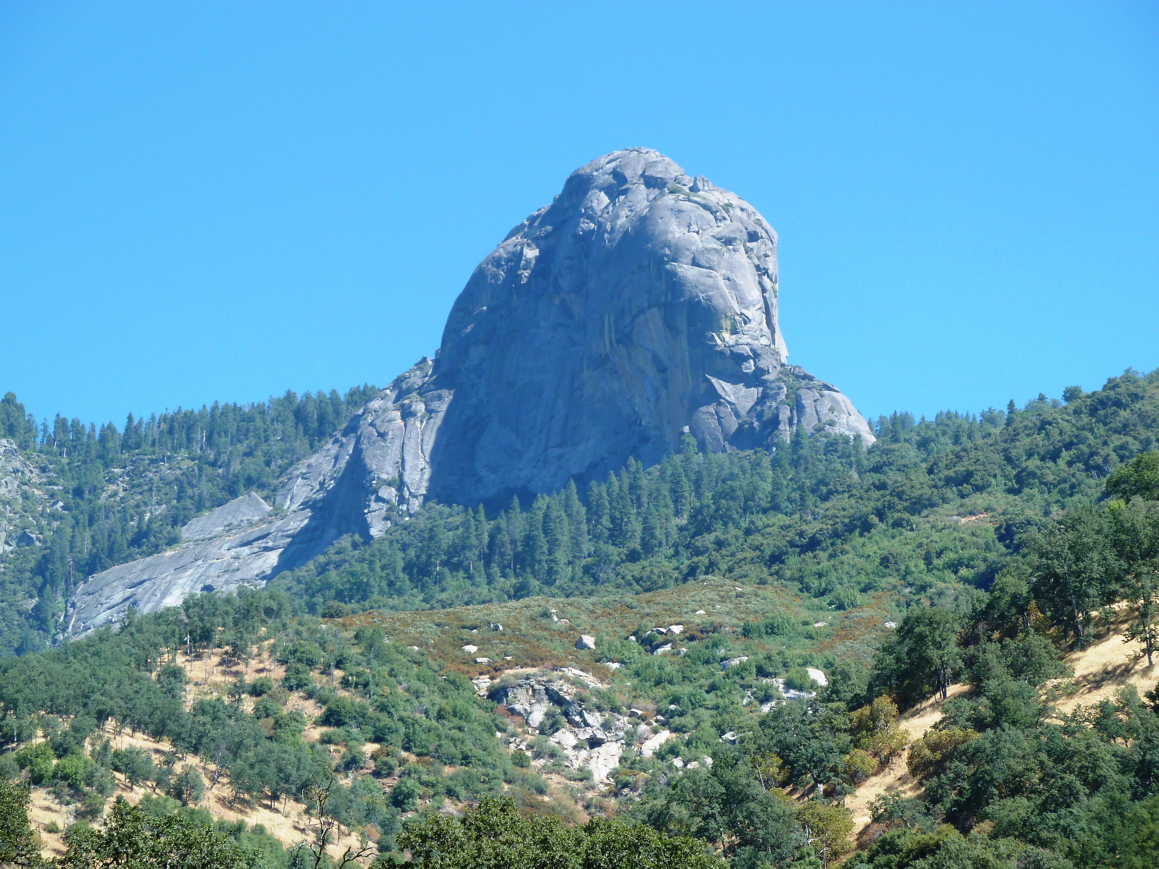
View of Moro Rock from Potwisha (near Hospital Rock), Sequoia National ParkElevation 6,725 ft (2,050 m) [1] Prominence 245 ft (75 m) [1] Location Location Sequoia National Park, Tulare County, California, United States Range Sierra Nevada Coordinates 36°32′39″N 118°45′54″W / 36.54417°N 118.765°W[2] Topo map USGS Giant Forest Geology Type Granite dome Age of rock Cretaceous Climbing First ascent 1861, by Hale Tharp, John Swanson and George Swanson Easiest route Hike Moro Rock is a granite dome rock formation in Sequoia National Park, California, USA. It is located in the center of the park, at the head of Moro Creek, between Giant Forest and Crescent Meadow. A stairway, built in the 1930s by the Civilian Conservation Corps, is cut into and poured onto the rock, so that visitors can hike to the top. The view from the rock encompasses much of the Park, including the Great Western Divide. Use of this trail is discouraged during thunderstorms and when it is snowing.
Contents
Recreation
The road to Moro Rock is closed in winter, so visitors need to hike 2 miles to reach the viewpoint. The road is open in summer so the hike is shortened. The 1996 general plan for the park calls for the road to Moro to be closed, and replaced by a shuttle. As of 2011, the shuttle is running, but the road is not yet closed.[3] The west face of Moro Rock offers 1,000 vertical feet of cracks and knobs for rock climbing. However, climbing is prohibited during peregrine falcon nesting season.[4]
Geology
Moro Rock is a dome-shaped granite monolith. Common in the Sierra Nevada, these domes form by exfoliation, the spalling or casting off in scales, plates, or sheets of rock layers on otherwise unjointed granite. Outward expansion of the granite results in exfoliations. Expansion results from load relief; when the overburden that once capped the granite has eroded away, the source of compression is removed and the granite slowly expands. Fractures that form during exfoliation tend to cut corners. This ultimately results in rounded dome-like forms.[5]
Stairway
Moro Rock Stairway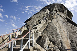
Built: 1931 Architect: National Park Service Architectural style: no style listed Governing body: National Park Service NRHP Reference#: 78000283 Added to NRHP: December 29, 1978[6] The first stairway leading to the summit of Moro Rock was constructed of wood and installed in 1917. This stairway deteriorated significantly by the late 1920s, and was replaced in 1931 by the present Moro Rock Stairway. Unlike the earlier stairway, the new stairway adopted a design policy of blending with the natural surfaces to the greatest extent possible. The 797-foot-long stairway was designed by National Park Service landscape architect Merel S. Sager and engineer Frank Diehl, following natural ledges and crevices. It has 400 steps that lead to the summit of Moro Rock.[7] Changes since the original construction have impaired the integrity of the design.[8]
References
- ^ a b "Moro Rock, California". Peakbagger.com. http://www.peakbagger.com/peak.aspx?pid=2774. Retrieved 2009-01-14.
- ^ "Moro Rock". Geographic Names Information System, U.S. Geological Survey. http://geonames.usgs.gov/pls/gnispublic/f?p=gnispq:3:::NO::P3_FID:263837. Retrieved 2009-01-14.
- ^ "Moro Rock and Crescent Meadow". Sequoia and Kings Canyon National Park. National Park Service. http://www.nps.gov/seki/historyculture/gfmoro.htm.
- ^ "Rock Climbing". Sequoia and Kings Canyon National Park. National Park Service. http://www.nps.gov/seki/planyourvisit/rockclimb.htm.
- ^
 This article incorporates public domain material from the National Park Service document "Geology Fieldnotes: Sequoia and Kings Canyon National Park".
 - ^ "National Register Information System". National Register of Historic Places. National Park Service. 2008-04-15. http://nrhp.focus.nps.gov/natreg/docs/All_Data.html.
- ^ "Moro Rock Stairway". List of Classified Structures. National Park Service. 2008-12-08. http://www.hscl.cr.nps.gov/insidenps/report.asp?STATE=CA&PARK=SEKI&STRUCTURE=&SORT=&RECORDNO=108.
- ^ William Tweed (1977). "National Register of Historic Places Inventory-Nomination: Moro Rock Stairway". National Park Service. http://pdfhost.focus.nps.gov/docs/NRHP/Text/78000283.pdf.
External links
- "Moro Rock". Summitpost.org. http://www.summitpost.org/show/mountain_link.pl/mountain_id/547. Retrieved 2006-12-03.
- "Giant Forest Points of Interest, Summer". Sequoia & Kings Canyon National Parks. National Park Service. http://www.nps.gov/seki/planyourvisit/gfpoisum.htm. Retrieved 2009-01-14.
- "Moro Rock Summit interactive 360˚ panorama". 360Around.com. http://rackphoto.com/pp/2010/05/22/moro-rock-sequoia-national-park/. Retrieved 2010-06-01.
National Register of Historic Places in Sequoia & Kings Canyon National Parks Other historic districts Generals' Highway Stone Bridges | Giant Forest Lodge Historic District | Giant Forest Village-Camp Kaweah Historic District | Mineral King Road Cultural Landscape | Shorty Lovelace Historic District
Other properties Ash Mountain Entrance Sign | Barton-Lackey Cabin | Cabin Creek Ranger Residence and Dormitory | Cattle Cabin | Hockett Meadow Ranger Station | Hospital Rock | Knapp Cabin | Moro Rock Stairway | Pear Lake Ski Hut | Quinn Ranger Station | Redwood Meadow Ranger Station | Smithsonian Institution Shelter | Squatter's Cabin | Tharp's Log
See also: National Register of Historic Places listings in Sequoia-Kings Canyon National Parks U.S. National Register of Historic Places Topics Lists by states Alabama • Alaska • Arizona • Arkansas • California • Colorado • Connecticut • Delaware • Florida • Georgia • Hawaii • Idaho • Illinois • Indiana • Iowa • Kansas • Kentucky • Louisiana • Maine • Maryland • Massachusetts • Michigan • Minnesota • Mississippi • Missouri • Montana • Nebraska • Nevada • New Hampshire • New Jersey • New Mexico • New York • North Carolina • North Dakota • Ohio • Oklahoma • Oregon • Pennsylvania • Rhode Island • South Carolina • South Dakota • Tennessee • Texas • Utah • Vermont • Virginia • Washington • West Virginia • Wisconsin • WyomingLists by territories Lists by associated states Other  Category:National Register of Historic Places •
  Portal:National Register of Historic PlacesCategories:
- Granite domes
- Sequoia National Park
- Landforms of Tulare County, California
- Buildings and structures on the National Register of Historic Places in California
- Rock formations in California

Wikimedia Foundation. 2010.