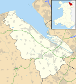
Delyn (district)

Delyn (district)

Coordinates: 53°16′01″N 3°10′34″W / 53.267°N 3.176°W / 53.267; -3.176

Delyn
Delyn within Wales
Geography
Status Borough
HQ Flint
History
Created 1974
Abolished 1996
Succeeded by Flintshire

Delyn is an area in north Wales. From 1974 to 1996 it was a district of Clwyd, but is now included in the county of Flintshire. Delyn is twinned with Menden, Germany.

The Borough of Delyn was formed in 1974 under the Local Government Act 1972 by the merger of Flint Municipal Borough with the urban districts of Holywell and Mold, and Holywell Rural District.

The name "Delyn" was formed by combining the names of the area's principal rivers: the Dee and the Alyn. The neighbouring district was originally named Alyn-Dee for the same reason. "Y Delyn" is also Welsh for "The Harp", a fact reflected in the borough's coat of arms.[1][2]

References


Wikimedia Foundation. 2010.

Игры ⚽ Поможем сделать НИР

Look at other dictionaries:

  • Delyn — can refer to: Delyn (district), a former district of Wales Delyn (UK Parliament constituency), a constituency based on the district Delyn (National Assembly for Wales constituency), a constituency based on the district This disambiguation page… …   Wikipedia

  • Holywell Rural District — infobox historic subdivision Name= Holywell HQ= Holywell Status= Rural District Start= 1894 End= 1974 Replace= Delyn Civic= PopulationFirst= 23,999 PopulationFirstYear= 1901 PopulationLast= 25,411 PopulationLastYear= 1971 AreaFirst=… …   Wikipedia

  • Maelor Rural District — Coordinates: 53°03′50″N 2°52′19″W / 53.064°N 2.872°W / 53.064; 2.872 …   Wikipedia

  • Monmouth (district) — Monmouth Welsh: Trefynwy Geography Status Borough …   Wikipedia

  • Montgomeryshire (district) — Coordinates: 52°38′24″N 3°28′08″W / 52.640°N 3.469°W / 52.640; 3.469 …   Wikipedia

  • Newport (district) — Coordinates: 51°35′17″N 2°59′53″W / 51.588°N 2.998°W / 51.588; 2.998 …   Wikipedia

  • Neath (district) — Coordinates: 51°39′40″N 3°48′14″W / 51.661°N 3.804°W / 51.661; 3.804 …   Wikipedia

  • Flintshire (historic) — Flintshire Welsh: Sir y Fflint Ancient extent of Flintshire Geography Status Ceremonial county (until 1974) Administr …   Wikipedia

  • Mold, Flintshire — Coordinates: 53°09′58″N 3°07′59″W / 53.166°N 3.133°W / 53.166; 3.133 …   Wikipedia

  • Districts of Wales — Districts (Wales) Category Districts Location Wales Found in Counties Created by …   Wikipedia

Share the article and excerpts

Direct link
Do a right-click on the link above
and select “Copy Link”