Cymau

Cymau

Cymau is a small village situated in the community of Llanfynydd, Flintshire on the edge of the mountains of north-east Wales. Its name is derived from the Welsh word cymau, an old form of the plural for cwm, "valley" or "hollow".

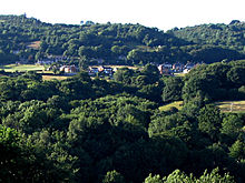
Cymau, seen from the south.

The village is located on the side of Hope Mountain, a land feature that can be seen for miles around. Neighbouring villages include Ffrith to the west and Brymbo to the south. The nearest towns are Wrexham to the south-east and Mold towards the north-west.

The area is known for its scenic beauty and large number of available hill-walking routes. The summit of Hope Mountain offers views of the Cheshire Plain and, in the opposite direction, it is possible to see sunsets behind the Welsh hills.

The population of Cymau is around 350. The village boasts a pub (The Old Talbot Inn) and one parish church with a roof made from corrugated iron and also a chapel. The former village Post Office and general store closed in 2009.

During the winter months, despite the local bus being occasionally unable to traverse the terrain, the village remains reasonably accessible.

External links

Coordinates: 53°05′42″N 3°03′12″W / 53.0949°N 3.0533°W / 53.0949; -3.0533


Wikimedia Foundation. 2010.

Игры ⚽ Поможем решить контрольную работу

Look at other dictionaries:

  • Tim Wright (musician) — For other musicians of this name, see Tim Wright (disambiguation). Timothy Brian Wright Circa. 2008 Background information Also known as …   Wikipedia

  • Flintshire (historic) — Flintshire Welsh: Sir y Fflint Ancient extent of Flintshire Geography Status Ceremonial county (until 1974) Administr …   Wikipedia

  • Moel Famau — The Jubilee Tower at the summit of Moel Famau. Elevation …   Wikipedia

  • Mold, Flintshire — Coordinates: 53°09′58″N 3°07′59″W / 53.166°N 3.133°W / 53.166; 3.133 …   Wikipedia

  • Mostyn — For other uses, see Mostyn (disambiguation). Coordinates: 53°18′50″N 3°16′08″W / 53.314°N 3.269°W / 53.314; 3.269 …   Wikipedia

  • Northop Hall — Coordinates: 53°12′04″N 3°05′10″W / 53.201°N 3.086°W / 53.201; 3.086 …   Wikipedia

  • Delyn (district) — Coordinates: 53°16′01″N 3°10′34″W / 53.267°N 3.176°W / 53.267; 3.176 …   Wikipedia

  • Deeside — For Strathdee in Scotland see River Dee, Aberdeenshire Deeside[1] (Welsh: Glannau Dyfrdwy) is the name given to the predominantly industrial conurbation of towns and villages that lie on, or near the River Dee in Chester.[2][3] These include,… …   Wikipedia

  • Mynydd Isa — Coordinates: 53°10′N 3°07′W / 53.17°N 3.12°W / 53.17; 3.12 …   Wikipedia

  • Clwydian Range — Moel Arthur, one of the Clwydian Range s hill forts. Seen from Moel Llys y Coed The Clwydian Range (Welsh: Bryniau Clwyd) is a series of hills and mountains in north east Wales that runs from Llandegla in the south to Prestatyn in the north, with …   Wikipedia

Share the article and excerpts

Direct link
Do a right-click on the link above
and select “Copy Link”