- Nannerch
-
Coordinates: 53°12′58″N 3°15′00″W / 53.216°N 3.25°W
Nannerch Welsh: Nannerch 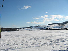
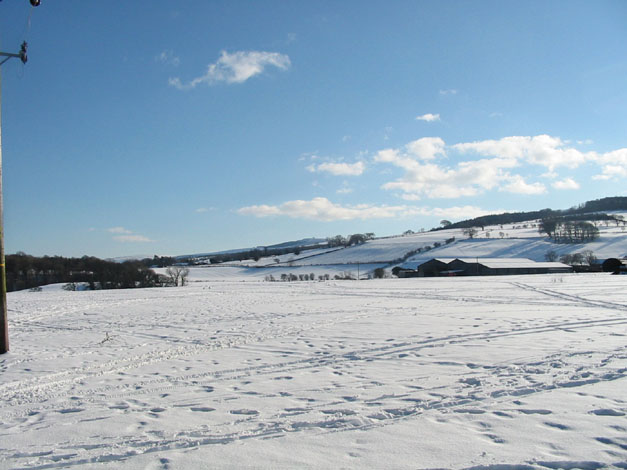
Spring snow 2006. Taken from the fields at the top of Bryn Celyn.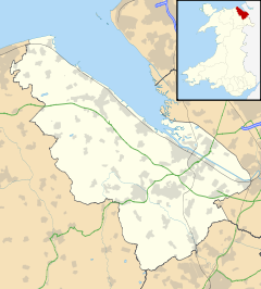
 Nannerch
Nannerch shown within FlintshirePopulation 531 (2001 Census)[1] OS grid reference SJ166695 Principal area Flintshire Ceremonial county Flintshire Country Wales Sovereign state United Kingdom Post town BUCKLEY Postcode district CH7 Dialling code 01352 Police North Wales Fire North Wales Ambulance Welsh EU Parliament Wales UK Parliament Delyn Welsh Assembly Delyn List of places: UK • Wales • Flintshire Nannerch is a village in Flintshire, north-east Wales. It is situated in an Area of Outstanding Natural Beauty. At the 2001 Census the population of Nannerch was 531.[1]
Contents
History
Nannerch is one of the ancient parishes of Flintshire, made up of the townships of Trellan, Trefechan, Trecwm and Tre Penbedw.
It is a quiet and attractive ancient village, sitting on a bedrock of carboniferous limestone, overlain by glacial boulder clay with glacial hollows. The limestone has been used in the construction of many local buildings. The ruins of Iron Age hill forts at Pen-y-Cloddiau and Moel Arthur are situated in the nearby hills.[2]
The old church, which was dedicated to St. Mary, was demolished in 1852, and a new building was erected on the same site. The new church, which is dedicated to St. Michael and All Angels, was consecrated on 29 September 1853. The church was designed by Thomas W. Wyatt, of London, the architect of the neighbouring churches of Brynford and Gorsedd.
Nannerch has no shops but has an attractive 18th century inn called The Cross Foxes. The pub has developed into a thriving business and also has a popular restaurant.
The village also has a very successful primary school. There are currently around 60 pupils enrolled. On the same site as the Victorian primary school is a small sports development consisting of a tennis court which doubles as a basketball/netball court and five-a-side football pitch, a grass football pitch and a bowling green. The bowling green also has a french-style boules piste next to it.
Nannerch has the advantage of being visited by a doctor twice a week at the village hall on Tuesday and Thursday mornings. On these days there is also a Post Office counter in the hall.
Theatre
The village has a very active dramatic group called the Nannerch Players. The Players perform two shows a year; one of these will be a pantomime, performed just before Christmas. One full-length play performed in the summer months (usually May-June). Current and recent productions include; Aladdin (Dec 2008), Murder at St Mags (July 2008), A Midsummer Night's Dream (open-air), The Office Party, Outside Edge, Frankenstein, Twelfth Night (open-air) and Romeo and Juliet (open-air). Rehearsals and performances are held in the village hall.
Transport
The peaceful nature of the village is helped by the main A541 Mold - Denbigh road effectively bypassing the village.
The Mold to Denbigh Junction railway, which opened in 1869, passed through the village. Nannerch railway station was situated near the point where the road into Nannerch forks left to leave the A541 road from Mold. After the line was closed in 1962, a victim of the Beeching Axe, the station was demolished and the road straightened. Besides passenger traffic, the station provided for the transportation of cattle and sheep heading for market, the distribution of local milk and the delivery of newspapers to the community.[2]
See also
- 1 and 2 Tai Cochion
References
- ^ a b 2001 Census: Nannerch, Office for National Statistics, http://neighbourhood.statistics.gov.uk/dissemination/LeadTableView.do?a=3&b=800993&c=nannerch&d=16&e=15&g=414450&i=1001x1003x1004&m=0&r=1&s=1217168329584&enc=1&dsFamilyId=779, retrieved 27 July 2008
- ^ a b Nannerch, http://www.cilcain.demon.co.uk/nannerch.html, retrieved 27 July 2008
Categories:- Villages in Flintshire

Wikimedia Foundation. 2010.