Moel y Parc

Moel y Parc
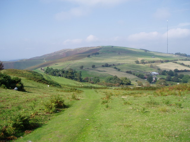
Moel y Parc viewed from the Offa's Dyke Path, with the television mast visible at right

Moel y Parc (sometimes written as Moel-y-Parc) is a country park in Britain. On the border between Denbighshire and Flintshire in Wales, it is one of the Clwydian Hills, rising 398 metres (1,306 ft) above sea level. It is located at OS grid reference SJ114703. There is a modern television mast near the summit.

Coordinates: 53°13′11″N 3°19′13″W / 53.2197°N 3.3204°W / 53.2197; -3.3204


Wikimedia Foundation. 2010.

Игры ⚽ Поможем сделать НИР

Look at other dictionaries:

  • Moel-y-Parc transmitting station — Moel y Parc …   Wikipedia

  • Moel Famau — The Jubilee Tower at the summit of Moel Famau. Elevation …   Wikipedia

  • Moel y Gaer, Rhosesmor — For other places with the same name, see Moel y Gaer. Remains of the rampart of Moel y Gaer Moel y Gaer (Welsh for bald hill of the fortress ) is a prehistoric hill fort located on a summit of Halkyn Mountain, overlooking the village of Rhosesmor …   Wikipedia

  • Moel Tŷ Uchaf — stone circle, above the village of Llandrillo. Moel Tŷ Uchaf is a stone circle near the village of Llandrillo, Denbighshire, North Wales. It is a collection of 41 stones with a cist in the centre and an outlying stone to the north north east. The …   Wikipedia

  • Moel Maelogan — Coordinates: 53°08′07″N 3°43′25″W / 53.13518°N 3.72371°W / 53.13518; 3.72371 …   Wikipedia

  • Clwydian Range — Moel Arthur, one of the Clwydian Range s hill forts. Seen from Moel Llys y Coed The Clwydian Range (Welsh: Bryniau Clwyd) is a series of hills and mountains in north east Wales that runs from Llandegla in the south to Prestatyn in the north, with …   Wikipedia

  • Wrexham-Rhos transmitting station — Infobox UK Transmitter name = Wrexham Rhos height = built = demolished = collapsed = relay = Moel y Parc BBC = BBC Wales ITV = ITV WalesThe Wrexham Rhos transmitting station (informally known as The Welsh and The Wand by locals) is an analogue… …   Wikipedia

  • Flint TV relay — The Flint TV relay is a television transmitter housed on a residential tower block called Bolingbroke Heights at the centre of the Town of Flint in North Wales. Flint is situated on the estuary of the River Dee which forms part the Wales border… …   Wikipedia

  • Northop — Coordinates: 53°12′14″N 3°07′48″W / 53.204°N 3.130°W / 53.204; 3.130 …   Wikipedia

  • Digital switchover dates in the United Kingdom —   Switchover not yet started …   Wikipedia

Share the article and excerpts

Direct link
Do a right-click on the link above
and select “Copy Link”