- Offa's Dyke Path
-
Offas Dyke Path 
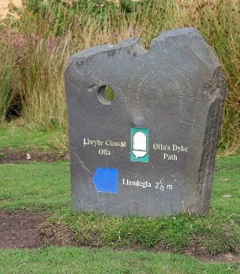
A marker post on Offa's Dyke Length 177 miles (285 km) Location English/Welsh border Designation National Trail Trailheads Sedbury51°37′57″N 2°38′54″W / 51.6324°N 2.6482°W
Prestatyn53°20′32″N 3°24′45″W / 53.3423°N 3.4126°WUse Hiking Season All year Sights It passes through historic towns and isolated hamlets. En route can be seen hill forts, castles, abbeys and surviving remains of the habitations of former occupants of the beautiful corridor of the path Offa's Dyke Path (Welsh: Llwybr Clawdd Offa) is a long distance footpath along the Welsh-English border. Opened in 1971, it is one of Britain's premier National Trails and draws walkers from throughout the world. Much of the 283 km (176 mi) long route either follows, or keeps close company with, the remnants of Offa's Dyke, an 8th century earthwork, the majority of which was probably constructed on the orders of Mercian King Offa.
Walking
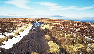 The summit of the Black Mountain crossed by the Offa's Dyke Path
Most walkers travel south to north, starting by the Severn Estuary, at Sedbury, near Chepstow, and finishing at Prestatyn on the north coast. The walk will take an average walker roughly 12 days to complete, although this can vary depending on individual fitness, attitude, the weather, age and experience.[1] Following a man-made border and ancient monument, rather than natural features, the dyke crosses a variety of different landscapes. The route crosses the Black Mountains, the Shropshire hills (including the many ups and downs of the 'Switchback', for many walkers the hardest part of the walk), the Eglwyseg mountains near Llangollen, and the Clwydian Range.
It passes through, or close to, the towns of Chepstow, Monmouth, Abergavenny, Hay-on-Wye, Kington, Knighton, Montgomery and then in and around the North Wales towns and villages of Llangollen, Llandegla, Clwyd Gate, Bodfari and Dyserth.
The half-way point of the walk is marked by the Offa's Dyke Centre in Knighton(52°20′45″N 3°03′06″W / 52.3458°N 3.0517°WCoordinates: 52°20′45″N 3°03′06″W / 52.3458°N 3.0517°W).[2]
“ a certain vigorous king called Offa......had a great dyke built between Wales and Mercia from sea to sea.
” — Asser
References
- ^ "ODA Website - mileages". http://www.offasdyke.demon.co.uk/mileages.htm. Retrieved 24 December 2007.
- ^ "ODA Website - ODC". http://www.offasdyke.demon.co.uk/odc.htm. Retrieved 24 December 2007.
External links
- National Trail website
- The Offa's Dyke Association
- Rambers' Association: Offa's Dyke Path National Trail
- Sherpa Van Project website: Offa's Dyke
- Walking Offa's Dyke Path
Long-distance footpaths in the United Kingdom National Trails (England and Wales) Cleveland Way · Cotswold Way · Glyndŵr's Way · Hadrian's Wall Path · North Downs Way · Norfolk Coast Path · Offa's Dyke Path · Peddars Way · Pembrokeshire Coast Path · Pennine Bridleway · Pennine Way · The Ridgeway · South Downs Way · South West Coast Path · Thames Path · Yorkshire Wolds Way
Long Distance Routes (Scotland) Transport in Powys Road 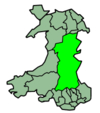
Footpaths Beacons Way · Cambrian Way · Epynt Way · Glyndŵr's Way · Marches Way · Offa's Dyke Path · Sarn Helen · Severn Way · Usk Valley Walk · Wye Valley WalkCycle routes Celtic Trail · Elan Valley Trail · Lake Vyrnwy Road Circuit · Lon Cambria · Lôn Las Cymru · Radnor Ring · Taff TrailRailway stations Cambrian Line Heart of Wales Line Builth Road · Cilmeri · Dolau · Garth (Powys) · Knucklas · Llanbister Road · Llandrindod · Llangammarch · Llangynllo · Llanwrtyd · Pen-y-Bont · Sugar Loaf
Welshpool and Llanfair
Light RailwayCastle Caereinion · Cyfronydd · Heniarth · Llanfair Caereinion · Sylfaen · Welshpool Raven Square
Categories:- Long-distance footpaths in the United Kingdom
- Recreational walks in Wales
- Transport in Shropshire
- Transport in Herefordshire
- Visitor attractions in Shropshire
- Visitor attractions in Herefordshire
- Long-distance footpaths in Wales
- Footpaths in Powys
- Long-distance footpaths in England
- Borders of Wales
- Borders of England


Wikimedia Foundation. 2010.