- North Downs Way
-
North Downs Way The North Downs Way near Hollingbourne Length 246 kilometres (153 mi)[1] Location South Eastern England, United Kingdom Designation UK National Trail Trailheads Farnham, Surrey
Dover, KentUse Hiking Highest point Botley Hill, approx. 260 m (853 ft) Season All year The North Downs Way is a long-distance path in southern England, opened in 1978.[2] It runs from Farnham to Dover, past Godalming, Guildford, Dorking, Merstham, Otford and Rochester, along the Surrey Hills Area of Outstanding Natural Beauty (AONB) and Kent Downs AONB.
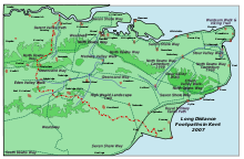
East of Boughton Lees, the path splits in two, the northern section running via Canterbury and the southern via Wye; at this stage the path crosses the Stour Valley Walk and passes the Wye Crown. The two sections of the path reunite at Dover. The northern route is 211 km long, and the southern route 201 km, the total length of the North Downs Way being 246 km.
The pathway is mixed-category in that it varies throughout length from footpath status to bridleway, byway and road. Some 19% of the Way follows roads, though 75% of those are minor lanes.[1]
The path (east of Boughton Lees, the southern section) runs along the ridge of the North Downs hills, and roughly follows the Pilgrims' Way path used by many pilgrims in the Middle Ages.
As the pathway runs through the downland, the trails and surrounding countryside are characterised by chalk-based soil and calcareous grassland with livestock grazing on the down slopes and clay soil and crop agriculture predominant in the valleys.
References
- ^ a b National Trails - Facts and Figures about the trail
- ^ Drewett, J (1985). "Chapter 1: Landscape and Countryside". Surrey. Shire County Guides (2nd ed.). Princes Risborough: Shire Publications. pp. 9–10. ISBN 9780-7478-0051-4.
See also
External links
Coordinates: 51°18′N 0°24′E / 51.3°N 0.4°ELong-distance footpaths in the United Kingdom National Trails (England and Wales) Cleveland Way · Cotswold Way · Glyndŵr's Way · Hadrian's Wall Path · North Downs Way · Norfolk Coast Path · Offa's Dyke Path · Peddars Way · Pembrokeshire Coast Path · Pennine Bridleway · Pennine Way · The Ridgeway · South Downs Way · South West Coast Path · Thames Path · Yorkshire Wolds Way
Long Distance Routes (Scotland) Surrey Hills Area of Outstanding Natural Beauty North Downs Botley Hill · Box Hill · Combe Bottom · Gatton Park · Hackhurst and White Downs · Headley Heath · Hog's Back · Mole Gap to Reigate Escarpment · Newlands Corner · Norbury Park · Ranmore Common · Seale Chalk Pit · Woldingham and Oxted DownsGreensand Ridge Albury Heath · Blackheath · Colyers Hanger · Devil's Jumps · Devil's Punch Bowl · Frensham Common · Gibbet Hill · Gong Hill · Hankley Common · Hankley Farm · Holmbury Hill · Leith Hill · Moor Park · Oxmoor Copse · Puttenham & Crooksbury Commons · St. Martha's Hill · Stockstone Quarry · Thursley Common · Winterfold Forest · Witley CommonLow Weald Rivers Lakes and ponds Long Distance Paths Downs Link · Greensand Way · Mole Gap Trail · North Downs Way · Thames Down Link · Vanguard Way · Wey South PathNational Cycle Routes Categories:- Geography of Surrey
- Visitor attractions in Surrey
- Geography of Kent
- Visitor attractions in Kent
- Long-distance footpaths in England
- Kent geography stubs
- Surrey geography stubs
Wikimedia Foundation. 2010.


